Site pages
Current course
Participants
General
Module 1: Watershed Management – Problems and Pros...
Module 2: Land Capability and Watershed Based Land...
Module 3: Watershed Characteristics: Physical and ...
Module 4: Hydrologic Data for Watershed Planning
Module 5: Watershed Delineation and Prioritization
Module 6: Water Yield Assessment and Measurement
Module 7: Hydrologic and Hydraulic Design of Water...
Module 8: Soil Erosion and its Control Measures
Module 9: Sediment Yield Estimation/Measurement fr...
Module 10: Rainwater Conservation Technologies and...
Lesson 6 Importance of Watershed Properties for Watershed Management
6.1 Watershed Management
Watershed management is the study of the relevant characteristics of a watershed aimed at the sustainable distribution of its resources. Watershed management is an important aspect of creating and implementing plans, programs, and projects to sustain and enhance watershed functions that affect the plant, animal, and human communities within a watershed boundary.
6.1.1 Objectives of Watershed Management
The different objectives of watershed management programs are:
To control damaging runoff and degradation and thereby conservation of soil and water.
To manage and utilize the runoff water for useful purpose.
To protect, conserve and improve the land of watershed for more efficient and sustained production.
To protect and enhance the water resource originating in the watershed.
To check soil erosion and to reduce the effect of sediment yield in the watershed.
To rehabilitate the deteriorating lands.
To moderate the floods peaks at downstream areas.
To increase infiltration of rainwater.
To improve and increase the production of timbers, fodder and livestock resources.
To enhance the ground water recharge, wherever applicable.
6.2 Effect of Physical Properties on Watershed Management
Certain physical properties of watersheds significantly affect the characteristics of runoff and as such are of great interest in hydrologic analyses. The effects of each physical property on watershed management are described under the following contents.
6.2.1 Size
The size of the watershed has significant effect on its function. Size of watershed determines the quantity of rainfall received retained and disposed off (runoff). A small watershed is pronounced by overland flow which is main contributor to result a peak flow. While a large watershed has no overland flow significantly, but channel flow is the main characteristic. Large watersheds are also affected by basin storage. Watershed size plays a role here, as it interacts with the extent of land use changes, as well as factors that affect weather and climate. In smaller watersheds, the predominant interaction is between weather scale runoff-causing events and the storm hydrograph; whereas, in larger watersheds, the predominant interaction is between climate-scale runoff-causing events and the annual hydrograph. While large-scale events or land use changes may impact small watersheds and even the storm hydrograph in large watersheds, smaller, localized runoff-causing events tend to produce more intensive precipitation over restricted areas, thus having a greater impact on the storm hydrograph in small watersheds or on small tributaries to larger watersheds.
6.2.2 Shape
The common watershed may be of square, rectangular, oval, fern leaf shaped, polygon-shaped, circular or triangular type and long or narrow. Larger the watershed, higher is the time of concentration and more water will infiltrate, evaporate or get utilized by the vegetation. Reverse is the situation when watershed is shorter in length as compared to width. The shape of the land, determined by geology and weather, greatly influences drainage patterns. The density of streams and the shape of a watershed, in turn, affect the rate of overland runoff relative to infiltration. A circular watershed would result in runoff from various parts of the watershed reaching the outlet at the same time. An elliptical watershed having the outlet at one end of the major axis and having the same area as the circular watershed would cause the runoff to be spread out over time, thus producing a smaller flood peak than that of the circular watershed.
6.2.3 Topography
Topographic configuration such as slope, length, degree and uniformity of slope affect both disposal of water and soil loss. Time of concentration and infiltration of water are thus a function of degree and length of slope of the watershed.
6.2.4 Drainage
Topography regulates drainage. Drainage density (length of drainage channels per unit area), length, width, depth of main and subsidiary channel, main outlet and its size depend on topography. Drainage pattern affect the time of concentration. A watershed with a high drainage density is characterized by quick response. Further, drainage cross section information is needed to determine the extent of flooding during high flows.
6.2.5 Area of the Watershed
The area of watershed is also known as the drainage area and it is the most important watershed characteristic for hydrologic analysis. It reflects the volume of water that can be generated from a rainfall. Determination of a workable size of watershed area is important for a successful watershed management programme.
6.2.6 Length of Watershed
Conceptually this is the distance traveled by the surface drainage and sometimes more appropriately labeled as hydrologic length. This length is usually referred for computing a time parameter, which is a measure of the travel time of water through a watershed (time of concentration). The watershed length is therefore measured along the principal flow path from the watershed outlet to the basin boundary. Since the channel does not extend up to the basin boundary, it is necessary to extend a line from the end of the channel to the basin boundary.
6.2.7 Slope of Watershed
Watershed slope affects the momentum of runoff. Both watershed and channel slope may be of interest. Watershed slope reflects the rate of change of elevation with respect to distance along the principal flow path. It is usually calculated as the elevation difference between the endpoints of the main flow path divided by the length. The elevation difference may not necessarily be the maximum elevation difference within the watershed since the point of highest elevation may occur along a side boundary of the watershed rather than at the end of the principal flow path. If there is significant variation in the slope along the main flow path, it may be preferable to consider several sub-watersheds and estimate the slope of each sub-watershed.
6.3 Effect of Geomorphologic Factors and Associated Processes on Watershed Management
6.3.1 Geological Rocks and Soil: Geological formation and rock types affect extent of water erosion, erodability of channels and hill faces, and finally sediment production. Rocks like shale’s, phyllites erode easily whereas igneous rocks do not erode. Physical and chemical properties of soil, specially texture, and structure and soil depth influence disposition of water by way of infiltration, storage and runoff. Soil types influence the rate of water movement (lateral and vertical) in the soil. For example, finely grained soils, such as clays, have very small spaces between soil particles, inhibiting infiltration and thus promoting greater surface runoff. Conversely, coarse soils, such as sands, have larger pore spaces allowing for greater rates of infiltration and reduced runoff. Surface roughness, soil characteristics such as texture, soil structure, soil moisture and hydrologic soil groups also affect the runoff in various ways. For example; Soil properties affect the infiltration capacity. Soil particles are usually classified as clay (d < 0.002 mm), silt (0.002 < d < 0.02), or sand (d > 0.02 mm). A particular soil is a combination of clay, silt, and sand particles. Generally, soils with a significant portion of small particles have low infiltration capacity, whereas sandy soils have high infiltration capacity.
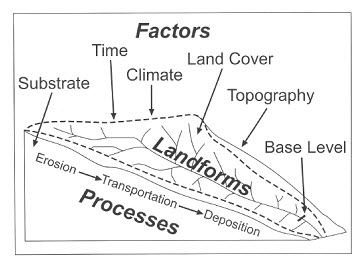
Fig. 6.1. Watershed Processes.
6.3.2 Climate: Climate parameters affect watershed functioning and its manipulation in two ways. Rain provides incoming precipitation temporally and spatially along with its various characteristic like intensity and frequency. The amount of rainfall and these parameters along with temperature, humidity, wind velocity, etc. regulates factors like soil and vegetation. Soil properties reflect the climate of the region. In the same way, the vegetation type of a region depends totally on the climate type.
6.3.3 Land Cover/ Vegetation: Depending upon the type of vegetation and its extent, this factor regulates the functioning of watershed; for eg. Infiltration, water retention, runoff production, erosion, sedimentation etc. Vegetation plays vital roles in the water cycle. It intercepts rainfall, impedes overland flow and promotes infiltration. Vegetation also uses water for growth. All of these factors reduce the quantity of runoff to streams. Vegetation binds and stabilizes soil, thereby reducing the potential for erosion. Vegetation also stabilizes stream banks and provides habitat for aquatic and terrestrial fauna. Vegetation functions to slow runoff and reduce soil compaction, allowing better percolation of rainfall into soils (infiltration) and groundwater recharge, which creates better water storage for summer base flows. In addition, the patterns, sizes, and composition of the vegetation affect reduction of soil erosion. Leaves and branches intercept the falling rain and reduce the effect of raindrop splash. Vegetative litter from dead leaves and branches builds up an organic surface that provides protection of the soil layer. Root systems also help to keep soil material stable from moving down slope.
6.3.4 Land Use: Type of land use, its extent and management are the key factors which affect watershed behavior. Judicious land use by users is of vital importance to watershed management and functioning. Change of land use within the watershed, especially within the variable source area, greatly affects the collection capacity and consequent runoff behavior of the watershed. The extent of land use change over the watershed has effects that are similar to the relationship between areal storm extent and watershed size. If the land use changes are local, then the impact of such changes is especially apparent in the storm hydrograph. The storm hydrograph is dominated by local characteristics. For land use changes that cover larger portions of the watershed, the impacts may also be observed in the annual hydrograph.
Keywords: Watershed Management, Watershed Processes, Geomorphologic Factors, Land Cover
References
Suggested Readings
Murty, J. V. S. (1994). Watershed Management in India. Wiley Eastern Limited.
Singh, V. P. (1992). Elementary Hydrology. Pearson College Division.
Subramanian, K. (1997). Engineering Hydrology. Tata McGraw-Hill Education.
Last modified: Thursday, 6 February 2014, 6:16 AM