Site pages
Current course
Participants
General
MODULE 1.
MODULE 2.
MODULE 3.
MODULE 4.
MODULE 5.
MODULE 6.
MODULE 7.
MODULE 8.
MODULE 9.
26 April - 2 May
Lesson 8. Radiation, Intersection and traversing
Methods of Plane table Surveying
1.Radiation method
2. Intersection method
3. Traversing method
1.RADIATION METHOD
The plane table is set up over only one station from which the whole traverse can be commanded. It is suitable for survey of small areas.
Procedure:
1) Select a point “O ” so that all points to be located are visible from it.
2) Set up the table at “O”, level it, and do centering.
3) SELECT A POINT “O” on the sheet so that it is exactly over station “O” on
4) Mark the direction of the magnetic meridian
5) Centering the alidade on “O” BISECT the objects of traverse A, B, C and D.
6) Measure the distances OA, OB, OC and OD and plotted to convenient scale to locate a, b, c and d respectively
7) Join the points a, b, c and d on the paper.
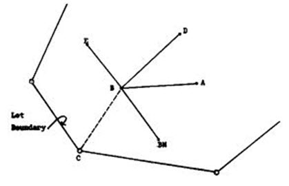
Fig. 8.1 Radiation method
2.INTERSECTION METHOD
In this method the plane table is shifted to a known distance in a particular direction marked on the ground and the line of sights are drawn to make intersection of the radial lines already drawn from the first set up of the instrument.
PROCEDURE:
1) Select two points P and Q such that the points (building corners) to be plotted are visible from their stations.
2) Set the table on P and locate on the sheet.
3) Pivot on P bisect Q draw a ray.
4) Measure the distance PQ and locate Q on the sheet to a convenient scale.
5) Now PQ is known as the base line.
6) Pivot ‘P’ bisects the inaccessible objects A and B (building corners) and draw rays.
7) Shift the table to ‘A’ such that P is over Q and do temporary adjustments.
8) Place the alidade along QP and the rotate the table till P is bisected, clamp table.
9) Pivot on Q bisect the objects A and B and draw rays.
10) The instruction of rays drawn from P and Q will give the points A and B.
11) To check the accuracy measured AB and compare with plotted distance AB.
12) The same procedure is applied for other features of the campus. each point is bisected from two stations.
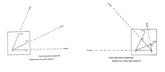
Fig. 7.2 Intersection method
3.TRAVERSE METHOD
We can traverse an area with the plane table along the boundry to prepare the map or plan of the area.
PROCEDURE:
1) Select the traverse stations A,B,C,D,E etc on the ground.
2) Set the table on starting station ‘a’ and perform temporary
adjustments.
3) Mark the magnetic meridian.
4) Locate A on the sheet as ‘a’.
5) Pivot on ‘a’ bisect the next station B and draw a ray
6) Measure the distance AB and locate ‘b’ on the sheet with a suitable scale.
7) Shift the table to next station B, set the table over B, and do temporary adjustments.
8) Place the alidade along ‘ba’ and bisect A for doing orientation of plane table.
9) Pivot on b bisect c draw a ray
10) Measure the distance BC and locate ‘c’ on the sheet with the suitable scale.
11) Report the same procedure at every successive station until the traverse is completed.
NOTE: By using radiation method, intersection and traversing methods we can locate the points on the paper, which were already on the ground. By using algebraic formulae, we can calculate the area of the given land.
FORMULAE:
1) Area of a triangle = ½ * base *height
2) Area of a square = side * side
3) Area of a rectangle = length * breadth
4) Area of a trapezium = ½ * (a + b) * h
A, b are the parallel sides. h is the distance between parallel sides.
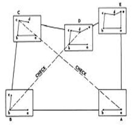
Fig 7.3 Traversing method
Last modified: Wednesday, 30 October 2013, 11:15 AM