Site pages
Current course
Participants
General
Module 1: Watershed Management – Problems and Pros...
Module 2: Land Capability and Watershed Based Land...
Module 3: Watershed Characteristics: Physical and ...
Module 4: Hydrologic Data for Watershed Planning
Module 5: Watershed Delineation and Prioritization
Module 6: Water Yield Assessment and Measurement
Module 7: Hydrologic and Hydraulic Design of Water...
Module 8: Soil Erosion and its Control Measures
Module 9: Sediment Yield Estimation/Measurement fr...
Module 10: Rainwater Conservation Technologies and...
Module 11: Water Budgeting in a Watershed
Module 12: Effect of Cropping System, Land Managem...
Module 13: People’s Participation in Watershed Man...
Module 14: Monitoring & Evaluation of Watershe...
Module 15: Planning and Formulation of Project Pro...
Module 16: Optimal Land Use Models
Keywords
Lesson 7 Importance of Watershed Planning
In this lesson, we shall discuss the definition and scope of watershed planning. Subsequently, we shall move on to the data required for watershed planning.
7.1 Definition and Scope of Watershed Planning
Planning is the process of formulation of a project consisting of practices/ strategies to achieve certain objective(s) by a definite time in future keeping the constraints in mind and considering all the available techniques. Watershed Planning pertains to the planning related to watershed(s), so as to achieve certain objective(s) related to watershed(s). Although planning is a continuous process, it is split into a time bound process to facilitate the evaluation of its impact over a time period. Like any planning, watershed planning also involves the integration of objectives, constraints, available techniques to improve the utility and effectiveness of the watershed(s) over a certain time period.
An Overview of Watershed Planning
Watershed planning involves the following three sets of factors:
Objectives must be established on the basis of a problem analysis;
Constraints to implementing a proposed management practice (i.e., project) need to be determined, including biophysical limitations, budget restrictions, and social/ cultural/ political conditions that are associated with the situation; and
There needs to be managerial techniques & capabilities available for implementing any proposed practice. Planning, therefore, involves the integration of objectives, constraints, and available techniques to improve the effectiveness and implementing watershed planning. The art of integration biological, physical and social sciences is emphasized here since planning is as much an art as it is a science. Each watershed related issue has its own unique set of technical characteristics and each management practice can require different technical approaches. The same does not hold for any general process of planning. A similar planning process can be used regardless of the type or number of watershed management practices being proposed. It is only the emphasis placed on each step in the process that will differ.
A basic principle in assessing both the positive and negative impact of watershed planning project is the application of what is called the ‘with-and-without concept’. In other words, we want to assess the changes that occur with and without any given watershed planning project. For example, when we talk about reducing sedimentation in a downstream reservoir, we are referring to the difference in sedimentation with and without erosion-control practices. Sedimentation can still be occurring with a given erosion-control practice but at a slower rate than without the practice. Not to be neglected, however, are the effects of the project on upload productivity where soil losses are avoided (and productivity is sustained over that period without the project).
A related principle is that the losses prevented by a watershed planning practice have to be treated in a similar way as the gains obtained when applying the with-and-without concept. For example, sedimentation in the reservoir can still be increasing following implementation of the planning project but at a slower rate than without the project. This is an important principle because so many of the benefits of integrated watershed management are losses prevented rather than net gains.
Steps in the Watershed Planning Process
The watershed planning process is likely to involve the following five sequential steps:
Monitor and evaluate past activities and identity problems and opportunities.
Identity the main characteristics of the problems confronted, opportunities to resolve these problems, and establish the objectives and constraints to accomplish these objectives. This eventually leads to the formulating strategies for action.
Identify alternative management practices (i.e., projects) to implement the formulated strategies within the limits of the constraints.
Appraise and evaluate the impacts of the alternative management practices (i.e., projects) including the environmental, social, and economic effects and assess the uncertainty associated with the impacts.
Rank or prioritize the alternative management practices and recommend the project to be implemented when a recommendation is requested.
Evaluating Past Activities and Identifying Problems/ Opportunities in Watershed Planning
The planning process has no beginning and no certain end. A logical starting point, however, is before a problem is identified through monitoring consisting of careful observation and measurement and evaluation of resource responses to climate, management, or the lack of management. Often, no formal monitoring or evaluation system is used to obtain the information that leads to identification of a watershed issue of concern and eventual action. Instead, problems are often observed only after they have occurred such as when the scars of erosion begin to appear on a landscape, when a reservoir is silting up rapidly, or when floods and/or droughts become more frequent. Opportunities to mitigate the problems are then identified.
Regardless of how watershed related problems and opportunities are recognized, their articulation becomes one of the first steps in watershed planning. In many instances, more than one solution to a problem is possible. For example, insufficient water supplies for downstream users might be enhanced by increasing the flows of water from an upstream watershed or developing reservoirs downstream to store water for future use. In other cases, some solutions are mutually exclusive with one action precluding another. While the specific actions taken in each case might differ, the planning process remains largely the same.
Establishing Objectives, Identifying Constraints, Developing Strategies for Watershed Planning
The next stage in the watershed planning process involves establishing objectives and identifying constraints in developing strategies to solve the problems or to take advantage of the opportunities. Objectives generally evolve from the watershed problem analysis. Statements of objectives indicate that there is a need to develop an effective response for overcoming or presenting the problem. A single objective or set of multiple objectives are then translated into actions that can be constrained by the risk involved in the approaches adopted, the level of economic resources necessary, and the level of success in accomplishing other objectives.
Once objectives have been established and constraints identified, a general strategy for action needs to be developed. The important thing here is not necessarily the strategy statement itself but the process by which it was developed. If we only look at the problem statement, we likely could think of a number of alternatives to solve the problem confronted. For example, we could suggest a watershed management practice involving the conversion of tine forest type to another to increase stream flows. In other cases, the best strategy might be to leave the situation alone and spending our resources elsewhere, such as developing groundwater resources or diverting water from a water-rich to a water-scarce area.
Identifying Alternative Ways to Implement the Watershed Planning Strategy
After an acceptable strategy has been developed, the planners get down to the details of evaluating the alternative projects that could be implemented. The need here is to identify the possible watershed management practice or project that could be used to successfully implement the strategy to obtain the results desired. This is where the technical specialists, social scientists, decision makers and others dealing with socioeconomic/ cultural issues come into the picture. The task of the planner is to identity the possibilities and the array of options that are available within the constraints and circumstances surrounding the watershed management project.
Appraising Watershed Planning Strategy Alternatives
While alternatives are being developed, they are also being appraised (i.e., evaluated). In its broadest meaning, the term appraisal refers to the process of identifying, defining, and quantifying the likely impacts of the watershed management practices. The separation of these impacts into economic/ financial, environmental and social effects relates to the different types of effects that a change in the watershed management can cause.
Making Appraisals Useful
Appraisals of proposed watershed management practices and projects are useful only if they provide timely information of relevance to the planner, manager, and decision maker. A distinction often needs to be made between the technical analyst’s considerations in choosing an appraisal procedure and the people’s viewpoint of what characterizes an acceptable appraisal of the alternatives. A task of the planner is to bring these two perspectives together in the final appraisals.
Appraisals of watershed management practices are pursued generally in sequential levels of analysis because the resources available for these appraisals are limited in most cases. Starting with only two alternatives, for example, one management action and the other option to do nothing, is generally too restrictive. The preferable approach is to start with a number of alternative management practices and then to narrow them down systematically in stages. This approach also encourages the introduction of economics into the planning process rather than tackling it on at the end of the planning process through a feasibility study.
Risk and Uncertainty in Watershed Planning Strategy Appraisals
A planner faces a situation of uncertainty more than the risk with the appraisals of most watershed management practices. One can apply probabilities to various outcomes in the case of risk, while measures of the probability of occurrence cannot be generated in the case of uncertainty. One can also develop subjective probability estimates for different aspects of the management practices in a situation of uncertainty. However, such estimates might do more harm than good since subjectivity in the planning process should not be hidden. Hence a sensitivity analysis is suggested, using which an analysis of how the measures of worth (i.e., value) or desirability of the alternative management practices change under different assumptions concerning the values of key parameters of the practices to be appraised.
Recommending Action
In some instances, a planner’s task stops when the alternatives and the implications of risk and uncertainty for the alternatives have been evaluated. In other cases, however, the planner might be asked for recommendations on which of the alternative management practices should be selected for implementation and the timing and approach to its implementation. To facilitate this selection, the appraisal results can be presented to the decision makers in different ways depending on the planning situation. Offering a ranked set of alternatives is often preferable or perhaps several rankings utilizing different appraisal criteria should be presented. Importantly, only the responsible decision maker can decide ultimately which alternative or set of alternatives need to be chosen.
Watershed Planning as a Continuous Process
Watershed Planning is a continuous process with information concerning results of the watershed management actions taken and emerging problems continuously fed back into the process. This information is then used to suggest possible changes in the ongoing watershed management practice(s). The process of collecting and disseminating information relating to ongoing management practices is part of the monitoring and evaluation effort. This Continuous process leads to valuable interactions among the planners, technical personnel and managers of watersheds and relevant decision makers.
7.2 Data Required for Watershed Planning
The data required for watershed planning can be grouped as follows:
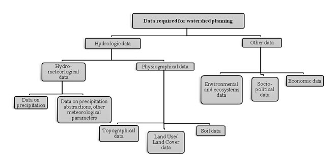
Fig. 7.1. Grouping of the data required for watershed planning.
To know what data is available and how to get district-level data or information, it is necessary to become familiar with state, district, block and city/village level agencies. It is important to understand the authority and jurisdictions of the agencies in the watershed. This understanding facilitates the search for information and also provides valuable insight into the activities which are most likely to be implemented in the watershed. For example, it is important that the watershed plan identify control actions or management practices that people or agencies in the watershed have the authority and jurisdiction to implement. This will help in selecting the management strategies that can be adopted at the local level with the existing authorities.
Other “local” Sources of watershed data include universities and environmental non-governmental organizations (NGOs). Although a university or a NGO might not be located in or near the watershed, it might be active in the watershed and hold relevant local data.
Universities can be important sources for demographic, climate, or spatial data. Many state climatology offices are associated with universities. In addition, university faculty or students regularly conduct environmental research related to their fields of study or expertise, sometimes providing data and information relevant to the local watershed planning efforts (e.g., water quality, soils, and land use changes). However, it might be difficult to identify any relevant studies and data without already knowing the specific project or contact. Universities have a variety of schools and departments, and no two are likely to be organized in the same way. Hopefully, if a university has conducted research on a watershed, one or more of the key stakeholders will be aware of it and can lead you in the right direction.
NGOs often may have information on stream condition, habitat and long-term changes in watershed characteristics (e.g., water quality). As with university information, it is difficult to identify NGOs active in the watershed and relevant data without already knowing about their existence. Typically, if a NGO has an active interest in a watershed or has collected data, the stakeholders involved will know about it.
State Sources of Information
State environmental agencies routinely collect biological, hydrological, and water quality information for the waters in the state. State environmental agencies include several divisions and offices, many of which might be useful in characterizing the watersheds and some of them might be irrelevant. Environmental agencies typically have a division or office dedicated to watershed or water quality issues. A variety of other offices deal with environmental issues (e.g., wastewater, mining, air quality) and they may have information relevant to a watershed. It is useful to visit either to the concerned state environmental agency’s office physically or visit its website to learn what types of offices work in a state and identify potential sources of relevant information.
In addition to the state environmental agencies, several other state agencies might be useful in characterizing the watershed and the potential sources. For example, the Department of Agriculture can provide agricultural statistics for the districts and blocks in a state.
Union Government Sources of Information
With the various offices, divisions, and agencies in the union or central government, there are several likely sources of every type of data used in watershed characterization. The remainder of this lesson identifies these data types and their corresponding sources.
7.2.1 Hydrologic Data Required
In this section, we will be discussing the hydrologic data required in watershed planning. As indicated already in Fig. 7.1, hydrologic data includes hydro-meteorological data and physiographical data. Hydro-meteorological data includes data on precipitation, abstractions of precipitation and other meteorological parameters, which influence the watershed management. Physiographical data broadly includes topographic data, land use-land cover data and soil data.
Information on the hydrology of the watershed is necessary to visualize and document the waterbody network, including the locations of all the water bodies and how they are connected to one another. When water flows through the stream network, it carries pollutant loads, and therefore the conditions of upstream segments can significantly affect the conditions downstream. When evaluating source impacts on watershed conditions, it is crucial to understand the hydrologic network of the watershed. Not only is this information important for characterizing the watershed, evaluating sources and water body conditions, but it is also a necessary input in the watershed planning.
Climate
Local climate data are often needed in watershed planning to help understand the local water budget for the region and also for modeling purposes. Hourly or daily precipitation data, as well as temperature, evaporation and wind speed are necessary for simulating rainfall-runoff processes in watershed models. However, if weather data are being used only to generally characterize weather patterns in the watershed, daily or monthly averages are sufficient. Daily and monthly temperature and precipitation data are generally available online in the Meteorological Department website. The data are available by station through the state climate data centers and sometimes with other state departments such as agriculture department, irrigation department etc.
Physiographical Data
Rivers and streams change in direct response to climate and human activities in the watershed. Increasing impervious surfaces like pavement, clearing forests and other vegetation, compacting soils with heavy equipment, and removing bank vegetation typically result in an adjustment in the pattern, profile, or dimensions of a river or stream. Assessments of river and stream geomorphology can help determine (1) the prior or “undisturbed” morphology of the channel; (2) current channel conditions; and (3) how the stream is evolving to accommodate changes in flow volumes/ timing/ duration, channel alteration, and so forth. This information is also helpful in analyzing the movement of sediment downstream from upland sources and channel banks.
Geo-morphological studies focus on characterizing the drainage area, stream patterns (single/ multiple channels, sinuosity, meander width), the longitudinal profile (gradient), channel dimensions (e.g., width/depth ratio relative to bank full stage cross section, entrenchment), bank and channel material, riparian vegetation, channel evolution trends, and other features. Because of the fairly recent development and application of analytical tools to assess and classify rivers and streams and explore the relationships among variables affecting their physical conditions, geo-morphological data are generally not available for many river systems.
Physical and Natural Features
The information on the physical and natural features of the watershed, including the type of data are available, their importance and their locations of availability need to be collected from appropriate data sources. Information on the physical and natural characteristics of the watershed will define the watershed boundary and provide a basic understanding of the watershed features that can influence watershed sources and pollutant loading.
Watershed Boundaries
Defining the geographic boundaries of the watershed planning effort is the first step in gathering and evaluating data. Up to this point, the watershed boundary might have been a theoretical boundary. We need to know for what watershed we are planning, but we might not have documentation of its physical boundary and the water bodies contained in it. Depending on the size of the watershed, its boundary might already have been delineated by a state or a union government agency.
Floodplain Maps
This information is also relevant to water quality protection and restoration activities because floodplains, when inundated, serve many functions and provide important habitats for a variety of fish and wildlife. Floodplains are important for spawning and rearing areas. Floodplain wetlands act as nutrient and sediment sinks, which can improve water quality in streams. They also provide storage that can decrease the magnitude of floods downstream, which can benefit fish and land owners in riparian areas. In addition, streams that are actively connected to their floodplains are less prone to severe erosion. Therefore, it is important to incorporate protection of these benefits of floodplain areas into the watershed management planning.
Topography
Characterizing the topography or natural features of the watershed can help to determine possible sources of pollution. For example, steep slopes might contribute more sediment loads to the water body than flat landscapes. Topographical information is also needed in many watershed models to route movement of runoff and loading across the land and to the water body. Digital elevation models (DEMs) are grid-based Geographic Information System (GIS) coverage that represent elevation. They can be displayed in a GIS and are used for delineating watersheds and displaying topography. One DEM typically consists of thousands of grid cells that represent the topography of an area. DEMs are available with 10 m, 30 m, and 90 m cell sizes [commonly known as map resolution]. The smaller cell sizes represent smaller areas and provide more detailed and accurate topographic data. However, GIS coverage with small grid cell sizes often have large file sizes and can be difficult to work with over large areas. The 30 m and 10 m DEMs are appropriate for smaller watersheds.
Water Body and Watershed Conditions
Several sources can provide helpful information on the current condition of the water bodies in your watershed, including whether they meet water quality standards and support designated uses. This information provides a general overview of the health of the water bodies in your watershed and what uses should be supported.
Wetland Assessments
Many programs use a wetland assessment or survey to serve as a baseline for future management activities. The survey might include global positioning system (GPS) coordinates of sample plots, a general plot description and condition assessment (i.e., land use impacts), canopy information or measurements, and digital pictures of sampling areas. In addition, the survey might document flora and fauna diversity observations. These datasets can be used to help characterize the watershed and identify wetland areas. In addition, State Wetland Conservation Plans are strategies for states to achieve no net loss and other wetland management goals by integrating regulatory and non-regulatory approaches to protecting wetlands.
Watershed Related Reports
In addition to state or local water quality reports, there might be existing watershed-related studies produced for all or a portion of your watershed under various state, local, or central [i.e., union] government programs. These studies might have a narrower focus than the watershed plan (e.g., source water, specific pollutant) or be out-of-date, but they can provide information on available data, potential pollutant sources, and historical water quality and watershed conditions. This section provides a few examples of current or recent programs that might provide relevant watershed information. This is not a comprehensive list of the programs or reports that could be available for a watershed, but it does highlight commonly used plans that can provide information relevant to watershed planning.
Land Use and Land Cover Data
Evaluating the land uses of a watershed is an important step in understanding the watershed conditions and source dynamics. Land use types (together with other physical features such as soils and topography) influence the hydrologic and physical nature of the watershed. In addition, land use distribution is often related to the activities in the watershed and therefore to the pollutant sources. Sources are often specific to certain land uses, providing a logical basis for identifying or evaluating sources. For example, sources of nutrients such as grazing livestock and fertilizer application associated with agricultural land uses would likely not contribute to loading from other land uses such as urban or forest land uses. Likewise, urban land uses typically have specific pollutants of concern (e.g., metals, oil and grease) different from those associated with rural land uses. Evaluating land use distribution and associated sources also facilitates identifying future implementation efforts because some management practices are most effective when applied to a certain land use.
This section discusses some of the most common sources of land use data. Typically, land use and land cover data are obtained from aerial photographs, satellite images and ground surveys. Because in some areas land uses continually change, it is important to keep in mind the type and date of available land use data when reviewing the sources of land use data for use in developing the watershed plan.
Soils
Soils can be an important factor in determining the amount of erosion and storm water runoff that occurs in your watershed. Soils have inherent characteristics that control how much water they retain, how stable they are, or how water is transmitted through them. Understanding the types of soils in your watershed and their characteristics helps to identify areas that are prone to erosion or are more likely to experience runoff.
7.2.2 Other Relevant Data Required
In this section, we will be discussing the other relevant data required for watershed planning. As already indicated in Fig. 7.1, the other relevant data essentially includes the environmental & ecosystems data, socio-political data and economic data.
Environmental and Ecosystems Data
The environmental data includes information on habitat, silviculture sources, cropland sources, fish & wildlife, livestock sources, biological data, water quality standards and pollutant sources. The pollutant sources include point and non-point pollution sources.
Ecosystem management requires that all aspects of a watershed (e.g., land, water, air, plants, and animals) be managed as a whole, not as separate and unrelated parts. Ecosystem management plans protect the viable populations of native species and the natural rhythms of the natural range of variability of the ecosystem. They allow public use of resources at levels that do not result in the degradation of the ecosystem. Successful, effective ecosystem management requires partnerships and interdisciplinary teamwork within the watershed.
There are a number of good resources for developing an ecosystem management plan. Land uses are an important factor influencing the physical conditions of the watershed, as well as an indicator of the types of sources active in the watershed. Together with land use characteristics, population can help you to understand the potential growth of the area and possible changes in land uses and sources.
Habitat
When characterizing the watershed, it is important to gather data not only to identify potential pollutant sources but also to identify areas for conservation, protection, and restoration. Maintaining high-quality wildlife and aquatic habitat is an important goal when developing watershed plans. High-quality, contiguous habitats and their buffers as well as small pockets of critical habitat, help prevent water quality damage and provide protection for both terrestrial and aquatic organisms.
Silviculture [i.e., limited area afforestation] Sources
Silviculture can be a significant source of sediment and other pollutants to a water body. The primary silviculture activities that cause increased pollutant loads are road construction and use, timber harvesting, site preparation, prescribed burning, and chemical applications. Without adequate controls, forestry operations can cause in stream sediment concentrations and accumulation to increase because of accelerated erosion. Silviculture activities can also cause elevated nutrient concentrations as the result of prescribed burns and an increase in organic matter on the ground or in the water. Organic and inorganic chemical concentrations can increase because of harvesting and fertilizer and pesticide applications. Harvesting can also lead to in stream accumulation of organic debris, which can lead to dissolved oxygen depletion. Other water body impacts include increased temperature from the removal of riparian vegetation and increased stream flow due to increased overland flow, reduced Evapo-transpiration, and runoff channeling.
Cropland Sources
Depending on crop type and management, croplands are a potentially significant source of nutrients, sediment and pesticides to watershed streams. Cropland can experience increased erosion, delivering sediment loads and attached pollutants to receiving water bodies. Fertilizer and pesticide application to crops increases the availability of these pollutants to be delivered to water bodies through surface runoff, erosion attached to sedimentation and ground water. If cropland is an important source of pollutants in the watershed, it is useful to determine the distribution of cropland as well as the types of crops grown. Land use coverage for the watershed can identify the areas of cropland in the watershed. The number of malfunctioning Systems can also be estimated by applying an appropriate failure rate from literature.
Fish and Wildlife
Identifying the types of wildlife and their habitat requirements in the watershed can help to identify areas for protection and conservation in the watershed plan. Previous watershed reports might provide information on wildlife in the watershed. In addition, local and state fish and wildlife offices can provide information on wildlife species and distribution in their jurisdictions.
Understanding the types of wildlife in the watershed can not only identify critical habitat areas to protect but sometimes also identify pollutant sources affecting water quality. For example, birds frequenting water can be a significant source of bacteria and nutrients to reservoirs and lakes. Although wildlife is an important component of the watershed ecology and should be protected, it is important to understand their impact on water body conditions when developing watershed plan.
Livestock Sources
In watersheds with extensive agricultural operations, livestock can be a significant source of nutrients and bacteria and can increase erosion. If available, site-specific information on livestock population, distribution, and management should be used to characterize the potential effects from livestock activities.
Biological Data
Aquatic life (e.g., fish, insects, plants) are affected by all the environmental factors to which they are exposed over time and integrate the cumulative effects of pollution. Therefore, biological data provide information on disturbances and impacts that water chemistry measurements or toxicity tests might miss. This makes these data essential for determining not only the biological health but also the overall health of a water body.
Water Quality Standards
We need to obtain the current water quality standards for the water bodies in the watershed to understand for what uses the water bodies should be protected and to compare in stream monitoring data with standards to evaluate the damage. We should also document the designated uses for the water bodies and any relevant criteria for evaluating the water body conditions.
Pollutant Sources: Point Sources and Non-point Sources
Pollutants can be delivered to water bodies from various point and nonpoint sources. Identifying and characterizing sources are critical to the successful development and implementation of a watershed plan and the control of pollutant loading to a stream. Characterizing and quantifying watershed pollutant sources can provide information on the relative magnitude and influence of each source and its impact on in stream water quality conditions. Watershed-specific sources are typically identified and characterized through a combination of generation, collection, and evaluation of GIS data, in stream data, and local information. However, some common types of pollutant sources might be contributing to watershed problems, and this section discusses information available to characterize them.
The discharge of pollutants from point sources, such as pipes, outfalls, and conveyance channels is generally regulated through permits. On the other hand, nonpoint Source pollution typically comes from many diffused sources, not specific pipes or conveyances. Nonpoint source pollution is caused by rainfall or snowmelt moving over and through the ground, carrying natural and man-made pollutants and finally depositing them into surface waters. Surface water runoff represents a major nonpoint source in both urban and rural areas. Runoff from urban watersheds can deliver a variety of pollutants from roadways and grassed areas, and rural storm water runoff can transport significant pollutant loads from crop-land, pastures, and livestock operations. Natural background sources like wildlife or geology (e.g., soils high in iron) can also contribute loadings and might be particularly important in forested or less-developed areas of the watershed. Additional nonpoint sources include on-site wastewater systems (septic tanks, cesspools) that are poorly installed, faulty, improperly located, or in close proximity to a stream and illicit discharges of residential and industrial wastes as well as open defecation in developing or under-developed countries.
Socio-Political Data
Socio-political or demographic data include information on the people in the watershed, such as the number of persons or families, commuting patterns, household structure, age, gender, race, employment, and educational information. This information can be used to help design public outreach strategies, identify specific sub-populations to target during the implementation phase, or help determine future trends and needs of the populations. Local governments usually collect demographic information on their communities either through decennial census operations or through the planning or economic departments.
Economic Data
Many watersheds contain economic data such as land owned by a variety of parties, including private citizens and union/ state/ district/ block government agencies. Although information on land ownership in a watershed might not help to characterize the physical nature of the area, it can provide insight into sources of information for characterizing the watershed or identifying pollutant sources. It can also be very useful in identifying watershed planning implementation opportunities.
Local Ordinances
Local ordinances that establish construction-phase erosion and sediment control requirements, river corridors and wetland buffers, and other watershed protection provisions are often included as part of a watershed plan implementation strategy. We need to check and see what current ordinances are in place for the communities involved through the planning or pollution control departments.
Land Management Practices
Information on how the land is managed in a watershed is helpful to identify both current control practices and potential targets for future management. This information will not only support the characterization of the watershed but also will be important in identifying current watershed sources, future management efforts, and areas for additional management efforts.
Keywords: Watershed planning, Steps in planning process, Appraising alternatives, Risk and uncertainty of appraisals, Hydro-meteorological data, Physiographical data, Environmental & ecosystems data.
References
Brooks, K. N., Ffolliott, P. F., Magner, J. A. (2013). Hydrology and the management of watersheds, Fourth Edition, Wiley-Blackwell, pp. 470-475.
United States Environmental Protection Agency (USEPA), (2008). Handbook for developing watershed plans to restore and protect our waters, USEPA, pp. 5-4 to 5-37.
www.dnr.maryland.gov/watersheds/.../planninguserguide/UserGuideChapter1; Dec. 15, 2013.
Suggested Reading
Tideman, E. M. (1999). Watershed Management- Guidelines for Indian Conditions. Omega Scientific Publishers, New Delhi.
www.dos.ny.gov/.../watershed/WatershedPlansGuidebook; Dec. 15, 2013.