Site pages
Current course
Participants
General
Module 1: Watershed Management – Problems and Pros...
Module 2: Land Capability and Watershed Based Land...
Module 3: Watershed Characteristics: Physical and ...
Module 4: Hydrologic Data for Watershed Planning
Module 5: Watershed Delineation and Prioritization
Module 6: Water Yield Assessment and Measurement
Module 7: Hydrologic and Hydraulic Design of Water...
Module 8: Soil Erosion and its Control Measures
Module 9: Sediment Yield Estimation/Measurement fr...
Module 10: Rainwater Conservation Technologies and...
Module 11: Water Budgeting in a Watershed
Module 12: Effect of Cropping System, Land Managem...
Module 13: People’s Participation in Watershed Man...
Module 14: Monitoring & Evaluation of Watershe...
Module 15: Planning and Formulation of Project Pro...
Module 16: Optimal Land Use Models
Keywords
Lesson 11 Water Yield
11.1 Concept of Water Yield
The water yield is defined as the amount of freshwater derived from unregulated flow (m3s-1) measurements for a given geographic area over a defined period of time. The freshwater flow (yield) is generated from a combination of base flow, interflow and overland flow originating from groundwater, precipitation and/or snowpack. The flow rate encompasses the hydrologic processes (for example, interception, infiltration and evapotranspiration), the state of water storage (for example, lakes, aquifers, snowpack and soil moisture) within a drainage basin, and is influenced by climatic (for example, temperature) and physiographic (for example, topography) variables of the watershed or basin. Flow is exclusively used to estimate water yield because it can be measured with a known level of accuracy compared to other parts of the water cycle such as precipitation and evapotranspiration, which can contain higher levels of uncertainty.
11.2 Water Yield Assessment
The water yield of a watershed may either be measured directly on a single outlet on the main stream or be calculated through empirical equations based on important physical properties of a particular watershed. Using the directly measured runoff values is, of course, the best way, but since it takes a long time and investments, the empirical method is preferred in applications. The methods of water yield assessment are discussed as below.
11.2.1 Direct Measurement Method: Water Yield can be roughly calculated by dividing the mean annual volume of stream flow (expressed in cubic meters per year) that is produced in a nested watershed (expressed in square kilometers). The area of a nested watershed can be determined using the following approach:
For example, (Fig. 11.1) the watershed associated with Station 1 has a nested area of 15 km2 and a gross area of 15 km2 (they are the same, as no further upstream watershed exists). The watershed associated with Station 2 has a nested area of 10 km2 and a gross area of 25 km2.
The water yield can also be expressed in mm (depth of water spread uniformly over the watershed area), as both precipitation and evaporation are typically expressed in mm. For example, a watershed with 1,000 mm annual precipitation, and an annual 40% (i.e. 400 mm), water loss due to evaporation, would have a water yield of 600 mm per year.
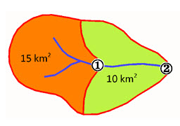
Fig. 11.1. Direct Measurement Method for Water Yield Estimation. (Source: Alberta Water Portal, 2013)
11.2.2 Water Budget Approach: Water yield from watersheds with deep soils and high infiltration capacities can be estimated with a water budget approach. Soil moisture storage characteristics govern the relationship between precipitation and water yield. Monthly values of precipitation and potential evapotranspiration (PET) are the only data required in this method. Soil moisture storage characteristics can be estimated from soil textural properties and the effective rooting depth of vegetation. The difference in precipitation and PET is considered roughly as the water yield from the watershed.
11.2.3 Upstream-Downstream Consideration: Increasing water yield from upland watersheds does not necessarily result in a significant increase in water yield at downstream reservoir sites or locations where water is extracted from the channel. As the distance increases between treated watersheds and the storage reservoir, opportunities for water losses from surface and channels (lateral and vertical losses of water from channels’ sections) increase as well. Riparian or phreatophyte vegetation along stream courses can result in large losses of water by transpiration. Likewise, transmission losses (leakage) within the channel can exceed any water yield increases from upstream areas, particularly in the case of ephemeral streams. Transmission losses can be approximated by –
Estimating the hydraulic conductivity of stream bottom material
Applying the hydraulic conductivity to the total area that is wetted by flow, and
Applying the above for the time duration of flow
Water yield improvement schemes should also take into account the evaporative losses from the reservoir pool. In more arid regions, reservoir evaporation can represent a large percentage of annual stream flow at the site. The relationship between incremental increase in storage and corresponding increase in surface area of the reservoir pool determine to a large extent, whether increased water at the reservoir will be available for the later use.
Once evaporation and seepage losses are estimated, the net water yield can be approximated at location of interest. The net water yield with and without watershed practices can then be examined over time, preferably using historical records that represent periods of water shortages or droughts. It is during such periods that additional water supplies represent the greatest benefit in terms of irrigation, municipal industrial supplies, fisheries production, etc.
11.3 Benefits of Water Yield Assessment
The benefits of water yield assessment can be listed as below
The assessment of water yield provides reliable information on availability of water resources (surface and ground water) to plan their extraction and uses.
It integrates the land processes affecting the water movement above and below the ground surface and thus reflects the management of watershed physical properties required to improve the water yield.
It provides information of interactions between head watershed to the tail watershed and thus provides a view on whether to develop conservation measures at head watershed to the tail watershed.
It provides information on water availability at a particular location of watershed as annual, seasonal and at even smaller time scale. This can be well used for planning the water use activities.
Provides an idea on surface and ground water interaction in the watershed.
11.4 Water Assessment and Management Perspectives
The first step in evaluating water yield benefits or cost is to quantify the relationship between land use and management practices that affect vegetative cover and the corresponding change in water yield. Watershed experiments indicate that water yield often increase when:
Forest are cleared or thinned
Vegetation is converted from deep rooted to shallow rooted species, and
Vegetation cover is changed from species from high to low interception capacities
The magnitude in change in water yield depends on the soils, climatic conditions and percentage of the watershed affected. The largest changes in water yield tend to follow complete forest removal. The length of time that water yield exceeds pre-cutting conditions depends on the type of vegetation that replaces the forest and the regrowth of vegetation on the site.
11.4.1 Land Use, Vegetation Cover and Water Production
The links between land use and water production, and the contribution of a particular vegetation cover to runoff and groundwater supplies, have been studied worldwide. Studies have confirmed that different land covers usually deliver different water yields, seasonally and annually, as well as in times of high and low flows. Achieving an understanding of catchment hydrodynamics and the inter-relationship with vegetation type is therefore essential to develop an integrated approach to land-use planning aimed at maximizing water yield at the watershed level. Influences of changing land use and vegetation cover on water yield are particularly important in the upper source areas, where environmental changes may result in reduced downstream flows and groundwater availability.
11.4.2 Impact of Afforestation
The impact of afforestation on the timing and seasonality of water yield is more ambiguous. The regulating capacity of the vegetation is generally very small compared to the soil and thus soil physical properties play a major role. Forests are generally known for a high soil infiltration capacities, enhancing base flow. However, soil destruction during the afforestation process, e.g. by heavy machinery, may hinder infiltration and stimulate surface runoff and further decrease low flows. On the long term, forest soils may regenerate, even up to a point where infiltration is higher than before afforestation. The afforestation reduces both dry and wet season flow. While the absolute flow reduction is largest during the wet season, the dry season experiences a larger proportional reduction, which may have important consequences for downstream water supply.
11.4.3 Groundwater / Base Flow Changes
Some pressure for upland watershed projects comes from downstream interests, which must cope with inadequate amounts of water in the stream channel during the normal dry season or low flow months. When precipitation is lacking, groundwater and reservoir storage can supplement water supplies. Small reservoir in the upland may indeed perform this function to some extent if there are releases during times of shortage. The constructions of numerous ponds in the headwaters is often not only a water conservation and development activity of benefit to the land owners, but in aggregate these may contribute to base flow through underground aquifers and thereby maintaining flows in streams longer in the dry season.
Keywords: Water Yield, Watershed, Water Budget, Afforestation.
References
Alberta water portal. URL: http://www.albertawater.com/index.php/projects-research/dynamics-of-alberta-s-water-supply/43-water-research/dynamics-of-alberta-s-water-supply/water-yield-and-streamflow-trend-analysis/548-alberta-s-water-yield . Last accessed: 29th September 2013
Suggested Readings
McKee, P. W., Clark, B. R., & Czarnecki, J. B. (2004). Conjunctive-Use Optimization Model and Sustainable-yield Estimation for the Sparta Aquifer of Southeastern Arkansas and North-Central Louisiana. US Department of the Interior, US Geological Survey.
McMahon, T. A., & Mein, R. G. (1986). River and reservoir yield. Littleton, Colorado, USA: Water resources publications.
Ratnayaka, D. D., Brandt, M. J., & Johnson, M. (2009). Water Supply. Butterworth-Heinemann.