Site pages
Current course
Participants
General
Module 1. Perspective on Soil and Water Conservation
Module 2. Pre-requisites for Soil and Water Conse...
Module 3. Design of Permanent Gully Control Struct...
Module 4. Water Storage Structures
Module 5. Trenching and Diversion Structures
Module 6. Cost Estimation
5 April - 11 April
12 April - 18 April
19 April - 25 April
26 April - 2 May
Lesson 1. Soil Erosion
1.1 Introduction
Soil erosion is the process by which soil is removed from the Earth's surface by exogenetic processes such as wind or water flow, and then transported and deposited in other locations. In general, soil erosion implies the physical removal of topsoil by various agents, including rain, water flowing over and through the soil profile, wind, glaciers or gravitational pull. Land and water are the most precious natural resources that support and sustain the anthropogenic activities. In India particularly, about 65% of the population depend on agriculture, the only sector which generates half of the employment and maintain ecological balance.
Soil erosion in India is amongst the leading areas of concern as it affects cultivation and farming in the country in adverse and unfavorable ways. Soil erosion leads to deprivation of physical characteristics of soils and damages plant and crops. In India almost 130 million hectares of land, i.e., 45 % of total geographical surface area, is affected by serious soil erosion through gorge and gully, shifting cultivation, cultivated wastelands, sandy areas, deserts and water logging. Soil erosion by rain and transportation of soil particles through rivulets that takes place in hilly areas causes severe landslides and floods. The anthropogenic activities including cutting trees for agricultural implements, firewood and timber; grazing by a large number of livestock over and above the carrying capacity of grass lands, traditional agricultural practices, construction of roads, indiscriminate quarrying and other activities, have all led to the opening of top surfaces to extreme soil erosion. In Indian condition, the control of soil erosion is a challenging task in the sense that the onset of monsoon often coincides with the kharif sowing and transplanting. In this stage of kharif crop when canopy cover is minimal, major part of the land is exposed to the rainfall let the land prone to soil erosion. It is prudent to check soil erosion from agricultural lands since it affects majority of people.
1.2 Types of Soil Erosion
Broadly, soil erosion can be divided into three categories depending on the eroding agents namely water erosion, wind erosion and chemical or geological erosion. Soil erosion due to the agents like water and wind is mostly prevalent and tangible. The erosion caused through chemical and geological agents is a slow process and continues to years and often it is non-tangible. Water erosion is further subdivided into classes depending on the effect of water erosion. These include sheet erosion, rill erosion, gully erosion, land slide or slip erosion and stream bank erosion.
1.2.1 Geologic Erosion
Geologic erosion sometimes referred to as natural or normal erosion; represent erosion under the cover of vegetation. It includes soil as well as soil eroding processes that maintain the soil in favorable balance, suitable for the growth of most plants. The rate of erosion is so slow that the loss of soil is compensated by the formation of new soil under natural weathering processes. The various topographical features such as existing of streams, valleys, etc. are the results of geologic erosion.
1.2.2 Wind Erosion
Wind erosion is the detachment, transportation and redeposition of soil particles by wind. A sparse or absent vegetative cover, a loose, dry and smooth soil surface, large fields and strong winds all increase the risk of wind erosion. Air movement must attain a certain velocity (with enough speed to generate visible movement of particles at the soil level) before it can generate deflation and transport of particles. Winds with velocities of less than 12-19 km/hr seldom impart sufficient energy at the soil surface to dislodge and put into motion sand-sized particles. Drifting of highly erosive soil usually starts when the wind attains a forward velocity of 25-30 km/hr. Wind erosion tends to occur mostly in low rainfall areas when soil moisture content is at wilting point or below, but all drought-stricken soils are at risk. Often the only evidence of wind erosion is an atmospheric haze of dust comprising fine mineral and organic soil particles that contain most of the soil nutrients. Actions to minimize wind erosion include improving soil structure so wind cannot lift the heavier soil aggregates; retaining vegetative cover to reduce wind speed at the ground surface; and planting windbreaks to reduce wind speed. Also, be ready for severe wind erosion seasons which tend to be the summers following dry autumns and winters. The most familiar result of wind erosion is the loss of topsoil and nutrients, which reduces the soil's ability to produce crops. Topsoil loss can be seen as rocky or gravelly knolls, thin soils mixed with lighter coloured subsoil, or the presence of calcium carbonate in surface soils.
Soil productivity is affected by wind erosion in various ways. Areas of erosion and deposition within a field increase the variation in soil characteristics, requiring more costly and less efficient soil management practices. Wind removes the smaller clay particles and organic matter from the soil while coarser materials are left behind. The continued loss of fine particles reduces soil quality. In shallow soils and soils with a hardpan layer, wind erosion also results in decreased root zone depth and water-holding capacity. Such changes may occur slowly and go unnoticed for many years especially if mixing by tillage masks the effects of wind erosion.
1.2.2.1 Process of Wind Erosion
The process of wind erosion comprises of three basic stages namely saltation, suspension and surface creep. Fig. 1.1 describes the process.
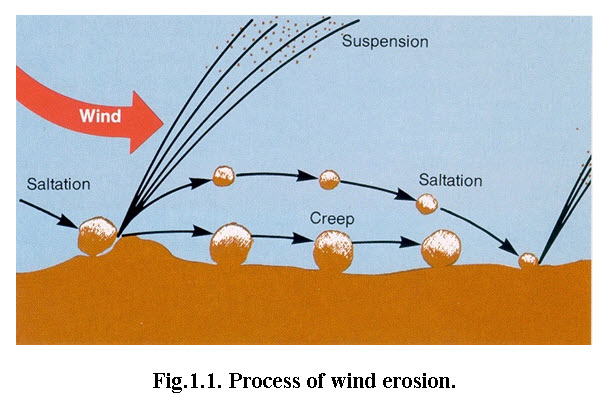
(Source:http://www.weru.ksu.edu/new_weru/images/CreepSaltSusp.jpg: accessed on 2 October 2013.)
(i) Saltation: Saltation occurs when the wind lifts larger particles off the ground for short distances, leading to sand drifts. Fine and medium sand-sized particles are lifted a short distance into the air, dislodging more soil as they fall back to the ground.
(ii) Suspension: Suspension occurs when the wind lifts finer particles into the air leading to dust storms. Very fine soil particles are lifted from the surface by the impact of saltation and carried high into the air, remaining suspended in air for long distances.
(iii) Surface Creep: The movement of large soil particles along the surface of the soil after being loosened by the impact of saltating particles.
1.2.2.2 Extent of Wind Erosion
Several factors, other than the wind velocity itself, contribute to wind erosion. These fall into two main groups of closely interrelated elements: those inherent in the properties of the soil per se and those associated with soil cover. A rough soil structure, especially at the surface, effectively reduces the movement of soil particles. Arid regions, however, are dominated by smooth, pulverized and structureless top soils. Soil texture also influences soil erodibility; soils of fine texture are, for example, particularly susceptible to wind erosion.
Measurements of dust in the air up to three metres above the soil surface at Jodhpur, India, showed that on a stormy day the amount of dust blowing varied between 50 and 420 kg/ha. In the Jaisalmer region of India, where wind speeds generally are higher, average soil loss of 511 kg/ha was recorded.
According to Global Assessment of Human-induced Soil Degradation (GLASOD), 21.6 Mha area of Indian soil is affected by wind erosion, which account for 6% of total geographical area. However, area varied from 12.9 to 38.7 Mha from various sources. The GLASOD assessment of extent of area under wind erosion is presented in Table 1.1
Table 1.1. GLASOD assessment: areas affected by wind erosion (Unit: 1000 ha) – South Asian Countries
|
Country |
Light |
Moderate |
Strong |
Total |
Total as percent of land |
|
Afghanistan |
1 873 |
0 |
209 |
2 082 |
5% |
|
Bangladesh |
0 |
0 |
0 |
0 |
0% |
|
Bhutan |
0 |
0 |
0 |
0 |
0% |
|
India |
0 |
1 754 |
9 042 |
10 796 |
6% |
|
Iran |
6 559 |
25 730 |
3 085 |
35 374 |
60% |
|
Nepal |
0 |
0 |
0 |
0 |
0% |
|
Pakistan |
3 998 |
6 742 |
0 |
10 740 |
42% |
|
Sri Lanka |
0 |
|
0 |
0 |
0% |
|
India, dry region |
0 |
1 754 |
9 042 |
10 796 |
- |
|
India humid region |
0 |
0 |
0 |
0 |
- |
|
Dry zone |
12 430 |
34 225 |
12 337 |
58 992 |
39% |
|
Humid zone |
0 |
0 |
0 |
0 |
0% |
|
Region |
12 430 |
34 225 |
12 337 |
58 992 |
18% |
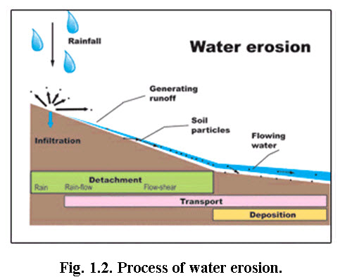
1.2.3 Water Erosion
The soil erosion caused by water as an agent is called water erosion. In water erosion, the water acts as an agent to dislodge and transport the eroded soil particle from one location to another (Fig. 1.2).
1.2.3.1 Extent of Water Erosion
The extent of water erosion in Indian subcontinent are presented in Table 1.2. In India, 32.8 Mha area in India is affected by water erosion which accounts for 18% of the land. However, the water erosion extent estimated by different sources varies from 87 to 111 Mha in India.
Table 1.2.GLASOD assessment: areas affected by water erosion (Unit: 1000 ha) – South Asian region
|
Region |
Light |
Moderate |
Strong |
Total |
Total as percent of land |
|
Afghanistan |
8 560 |
2 597 |
0 |
11 156 |
29% |
|
Bangladesh |
0 |
1 504 |
0 |
1 504 |
15% |
|
Bhutan |
36 |
0 |
4 |
40 |
10% |
|
India |
2 936 |
17 217 |
12 620 |
32 773 |
18% |
|
Iran |
14 504 |
11 896 |
0 |
26 400 |
45% |
|
Nepal |
520 |
1 072 |
0 |
1 592 |
34% |
|
Pakistan |
6 080 |
1 124 |
0 |
7 204 |
28% |
|
Sri Lanka |
72 |
157 |
845 |
1 074 |
46% |
|
India, dry region |
1 177 |
0 |
1676 |
2 853 |
- |
|
India, humid region |
1 759 |
17 217 |
10 944 |
29 920 |
- |
|
Dry zone |
30 320 |
15 617 |
1 676 |
47 613 |
32% |
|
Humid zone |
2 387 |
19 951 |
11 791 |
34 130 |
20% |
|
Region |
32 707 |
35 568 |
13 468 |
81 743 |
25% |
The state wise extent of soil erosion from wind as well water is presented in Table 1.3. The Fig.s are adopted from National Bureau of Soil Survey & Land Use Planning(NBSS&LUP 2005). The NBSS&LUP estimates are higher in case of water erosion and lower in case of wind erosion when compared to GLASOD.
Table 1.3. Extent of erosion in India
|
Sl. No. |
Name of the States |
Water Erosion (1000 ha) |
Wind Erosion (1000 ha) |
|
Andhra Pradesh |
11518 |
0 |
|
|
Arunachal Pradesh |
2372 |
0 |
|
|
Assam |
688 |
0 |
|
|
Bihar+ Jharkhand |
3024 |
0 |
|
|
Goa |
60 |
0 |
|
|
Gujarat |
5207 |
443 |
|
|
Haryana |
315 |
536 |
|
|
Himachal Pradesh |
2718 |
0 |
|
|
Jammu & Kashmir |
5460 |
1360 |
|
|
Karnataka |
5810 |
0 |
|
Kerala |
76 |
0 |
|
Madhya Pradesh + Chhattisgarh |
17883 |
0 |
|
Maharastra |
11179 |
0 |
|
Manipur |
133 |
0 |
|
Mizoram |
137 |
0 |
|
Meghalaya |
137 |
0 |
|
Nagaland |
390 |
0 |
|
Orissa |
5028 |
0 |
|
Punjab |
372 |
282 |
|
Rajasthan |
3137 |
6650 |
|
Sikkim |
158 |
0 |
|
Tamil Nadu |
4926 |
0 |
|
Tripura |
121 |
0 |
|
Uttar Pradesh + Uttarakhand |
11392 |
212 |
|
West Bengal |
1197 |
0 |
|
Delhi |
55 |
0 |
|
Union Territories |
187 |
0 |
|
|
Grand Total |
93680 |
9483 |
|
Grand Total(Million ha) |
93.68 |
9.48 |
(Source: NBSS&LUP, 2005)
1.2.3.2 Types of Water Erosion
The different types of water erosion are described in the following section.
1.2.3.2.1 Splash Erosion
This type of soil erosion is because of the action of raindrop. The kinetic energy of falling raindrop dislodges the soil particle and the resultant runoff transports soil particles. Splash erosion (Fig. 1.3) is the first stage of soil erosion by water. It occurs when raindrops hit bare soil. The explosive impact breaks up soil aggregates so that individual soil particles are ‘splashed’ onto the soil surface. The splashed particles can rise as high 0.60 meter above the ground and move up to 1.5 meter from the point of impact. The particles block the spaces between soil aggregates, so that the soil forms a crust that reduces infiltration and increases runoff.
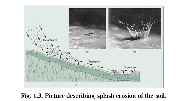
(Source: http://restoringutopia.blogspot.in/2010/07/like-hollow-point-bullets-from-sky.html : accessed on 2 October 2013)
1.2.3.2.2 Sheet Erosion
Sheet erosion (Fig. 1.4) is the removal of soil in thin layers by raindrop impact and shallow surface flow. This action called skimming and is prevalent in the agricultural land. It results in loss of the finest soil particles that contain most of the available nutrients and organic matter in the soil. Soil loss is so gradual that the erosion usually goes unnoticed, but the cumulative impact accounts for large soil losses. This type of soil erosion is mainly responsible for loss of soil productivities. Soils most vulnerable to sheet erosion are overgrazed and cultivated soils where there is little vegetation to protect and hold the soil. Early signs of sheet erosion include bare areas, water puddling as soon as rain falls, visible grass roots, exposed tree roots, and exposed subsoil or stony soils. Soil deposits on the high side of obstructions such as fences may indicate active sheet erosion.
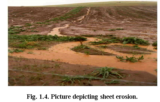
(Source: http://soer.justice.tas.gov.au/2003/image/101/index.php)
Vegetation cover is vital to prevent sheet erosion because it protects the soil, impedes water flow and encourages water to infiltrate into the soil. The surface water flows that cause sheet erosion rarely flow for more than a few meters before concentrating into rills.
1.2.3.2.3 Rill Erosion
Rills formation is the intermittent process of transforming to gully erosion. The advance form of the rill is initial stage of gully formation. The rills are shallow drainage lines less than 30cm deep and 50 cm wide. They develop when surface water concentrates in depressions or low points through paddocks and erodes the soil. Rill erosion is common in bare agricultural land, particularly overgrazed land, and in freshly tilled soil where the soil structure has been loosened. The rills can usually be removed with farm machinery. Rill erosion is mostly occurs in alluvial soil and is quite frequent in Chambal river valley in India. The typical rill formation is presented in Fig. 1.5.
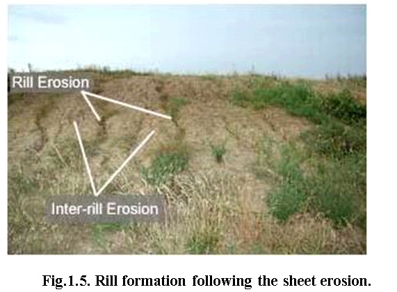
(Source: http://passel.unl.edu/UserFiles/Image/siteImages/Rillerosion-LGjpg.jpg: accessed on 2 October 2013)
1.2.3.2.4 Gully Erosion
The advance stage of rills is transformed into initial stage of gully. Gully formation are initiated when the depth and width of the rill is more than 50 cm. Gullies (Fig. 1.6) are deeper channels that cannot be removed by normal cultivation. Hillsides are more prone to gullying when they cleared of vegetation, through deforestation, over-grazing or other means. The eroded soil is easily carried by the flowing water after being dislodged from the ground, normally when rainfall falls during short, intense storms. Depending upon the depth and width, the gullies further divided into 4 classes namely G1, G2, G3 and G4 (Table 1.4). Gullies reduce the productivity of farmland where they incise into the land, and produce sediment that may clog downstream water bodies. Because of this, much effort are required to invested into the study of gullies within the scope of geomorphology, in the prevention of gully erosion, and in restoration of gullied landscapes. The total soil loss from gully formation and subsequent downstream river sedimentation can be sizable.
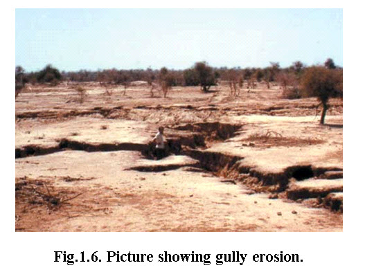
(Source: CSWCRTI, Dehradun: accessed on 2 October 2013)
Table 1.4. Classification of Gully
|
Particulars |
Description of symbols of Gully |
|||
|
G1 |
G2 |
G3 |
G4 |
|
|
Depth in meter |
Upto 1.0 |
1.0-3.0 |
3.0-9.0 |
>9.0 |
|
Width in meter |
<18.0 |
<18.0 |
18.0 |
>18.0 |
|
Side slope (%) |
<6.0 |
<6.0 |
6.0-12.0 |
>12.0 |
1.2.3.2.5 Tunnel Erosion
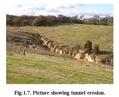
Tunnel erosion (Fig. 1.7) occurs when surface water moves into and through dispersive subsoils. Dispersive soils are poorly structured so they erode easily when wet. The tunnel starts when surface water moves into the soil along cracks or channels or through rabbit burrows and old tree root cavities. Dispersive clays are the first to be removed by the water flow. As the space enlarges, more water can pour in and further erode the soil. As the tunnel expands, parts of the tunnel roof collapse leading to potholes and gullies. Indications of tunnel erosion include water seepage at the foot of a slope and fine sediment fans downhill of a tunnel outlet. This type of erosion is more frequent in foothills where elevation is between 500-750 meter.
(Source: http://www.ccma.vic.gov.au/soilhealth/photos.htm: accessed on 2 October 2013.)
1.2.3.2.6 Stream Bank Erosion
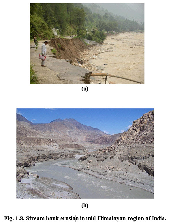
Stream bank erosion (Fig. 1.8) occurs where streams begin cutting deeper and wider channels as a consequence of increased peak flows or the removal of local protective vegetation. Stream bank erosion is common along rivers, streams and drains where banks have been eroded, sloughed or undercut. This is quite prevalent in alluvial river and streams. Generally, stream bank erosion becomes a problem where development has limited the meandering nature of streams, where streams have been channelized, or where stream bank structures (like bridges, culverts, etc.) are located in places where they can actually cause damage to downstream areas. Stabilizing these areas can help protect watercourses from continued sedimentation, damage to adjacent land uses, control unwanted meander, and improvement of habitat for fish and wildlife.
(Source: http://www.flickr.com/photos/sarfrazh/3849502770/)
1.2.3.2.7 Coastal erosion
The waves, geology and geomorphology are the three major factors that affect the coastal erosion. Waves are the cause of coastal erosion. Wave energy is the result the speed of the wind blowing over the surface of the sea, the length of fetch and the wind blowing time. The geology of the coastline also affects the rate of erosion. If the coast is made of a more resistant type of rock (say, granite), the erosion rate will be lower than if the coast is made of a less resistant type of rock (say, boulder clay). The geomorphology(or shape) of the coastline further affects the rate of erosion. Headlands cause wave refraction, making waves converge and combining their energy. Wider, shallower bays, meanwhile, allow waves to diverge, losing energy due to friction with the sea bed. A wider beach cause more wave energy to be lost due to friction before the waves can break. A narrower beach will mean that the breaking point of the waves is closer to the coastline, and less energy will have been lost due to friction before they break. Similarly, shingle and pebbles will allow more water to infiltrate and cause more wave energy to be lost due to friction, while sandy beaches allow less infiltration and cause less friction and so allow for a higher rate of erosion. If the beach gradient is steep, this will encourage steeper, higher-energy waves. Paradoxically, though, because shingle and pebble beaches leave less energy for backwash, material tends to be moved upwards, making the beach steeper. The coastal erosion is a major concern for India as about 40% of the Indian coasts are subjected to severe erosion that has the potential to change the coast line. The typical coastal erosion is presented in Fig. 1.9.
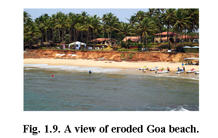
(Source: http://www.concierge.com/ideas/beachisland/tours/)
1.3 Effects of Soil Erosion
The soil erosion adversely affects the livelihood of the people in one way or other. The major losses and problem occurs due to the soil erosion from various agents are listed below.
Siltation of rivers.
Siltation of irrigation channels and reservoirs.
Problems in crop irrigation and consequent need of conserving the water.
Damage to sea coast and formation of sand dunes.
Disease and public health hazards.
Soils eroded by water get deposited on river beds, thus increasing their level and causing floods. These floods sometime have various extreme effects, such as killing human and animals and damaging various buildings.
Soil erosion decreases the moisture supply by soil to the plants for their growth. It also affects the activity of soil micro-organisms thus deteriorating the crop yield.
Top layer of soil contains most of the organic matter and nutrients, loss of this soil reducing soil fertility and affecting its structure badly.
Wind erosion is very selective, carrying the finest particles - particularly organic matter, clay and loam for many kilometres. There the wind erosion causes losses of fertile soils from highly productive farming areas.
The most spectacular forms are dunes - mounds of more or less sterile sand - which move as the wind takes them, even burying oases and ancient cities.
Sheets of sand travelling close to the ground (30 to 50 metres) can degrade crops.
Wind erosion reduces the capacity of the soil to store nutrients and water, thus making the environment drier.
References
Michael, A.M. and Ojha, T.P. (1978). Principles of Agricultural Engineering, Vol. II, Jain Brothers, New Delhi, India.
Morgan, R.P.C. (2005). Soil Erosion and Conservation, Third edition, Blackwell Publishing, UK.
Schwab, Glenn O., Frevert, Richard K., Edminster, Talcott W., and Barnes, Kenneth K. (1981). Soil and Water Conservation Engineering, Third edition, John Wiley and Sons, New York.
Suresh, R. (1997). Soil and Water Conservation Engineering, Second edition, Standard Publisher Distributors, Delhi, India.
Sharda, V.N., Juyal, G.P., Prakash, C. and Joshi, B.P. (2007). Training Manual on Soil Conservation and Watershed Management, Vol II: Soil and Water Conservation Engineering, CSWCRTI, Dehradun, Saraswati Press, Dehradun, India.
Internet References
http://www.flickr.com/photos/sarfrazh/3849502770/
http://www.concierge.com/ideas/beachisland/tours/
http://www.ccma.vic.gov.au/soilhealth/photos.htm
http://passel.unl.edu/UserFiles/Image/siteImages/Rillerosion-LGjpg.jpg
http://soer.justice.tas.gov.au/2003/image/101/index.php
http://restoringutopia.blogspot.in/2010/07/like-hollow-point-bullets-from-sky.html
Suggested Readings
Suresh, R. (1997). Soil and Water Conservation Engineering, Second edition, Standard Publisher Distributors, Delhi, India.
Michael, A.M. and Ojha, T.P. (1978). Principles of Agricultural Engineering, Vol. II, Jain Brothers, New Delhi, India.
Schwab, Glenn O., Frevert, Richard K., Edminster, Talcott W., and Barnes, Kenneth K. (1981). Soil and Water Conservation Engineering, Third Edition, John Wiley and Sons, New York.
Last modified: Tuesday, 21 January 2014, 5:23 AM