Site pages
Current course
Participants
General
Module.1 Introduction of Water Resources and Hydro...
Module.2 Precipitation
Module.3 Hydrological Abstractions
Moule.4 Types and Geomorphology of Watersheds
Module 5. Runoff
Module 6. Hydrograph
Module 7. Flood Routing
Module 8. rought and Flood Management
19 April - 25 April
26 April - 2 May
Lesson 15 Types of Watersheds
15.1 Definition of Drainage Basin
It is defined as, “any portion of the earth's surface within a physical boundary defined by topographic slopes that divert all runoff to the same drainage outlet.”
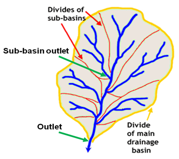
Fig.15.1.Drainage basin with its sub-basins.
(Source:http://nationalatlas.gov/articles/geology/a_continentalDiv.html)
This definition permits the selection of any drainage outlet desired. One can move the drainage outlet up the drainage system or down the drainage system to any location of interest (makes possible the sub-basin studies).
By definition, any point on the main drainage system can be selected as the basin outlet. Thus, a basin is defined with respect to the outlet.
The physical boundary of the drainage basin is called the drainage divide.The watershed area includes all the points that lie above the elevation of the outlet and within the drainage divide that separates adjacent watersheds.
Other terms synonymous with drainage basin are watershed, catchment, basin, river basin, runoff area, and stream basin. Watershed, catchment and basin are most commonly used terms by hydrologists.
Watersheds can be classified based on size, mean slope, length, land use, etc. Two hydrologically meaningful criteria are size and land use.
15.2 Classification of Watersheds by Size
Three types of watershed are distinguished according to size:
-
Small size: < 250 km2
-
Medium size: between 250 km2- 2500 km2
-
Large: >250 km2
This classification is vague, but the implication is in terms of spatial heterogeneity and dampening (averaging) of hydrological processes.
Runoff generation on these watersheds can be considered in two phases: i) land phase and ii) channel phase. Each phase has its own storage characteristics.
15.2.1 Large Watersheds
1) They have well-developed channel networks and channel phase, and, thus, channel storage is dominant.
2) They are less sensitive to high-intensity rainfalls of short duration.
15.2.2 Small Watersheds
1) They have dominant land phase and overland flow, have relatively less conspicuous channel phase.
2) They are highly sensitive to high-intensity, short-duration rainfalls.
Two watersheds of the same size may behave very differently if they do not have similar land and channel phases.
Small watersheds are usually least heterogeneous and large watersheds are most heterogeneous. In other words, spatial variability of watershed characteristics increases with size.
As the watershed size increases, storage increases and averaging of hydrologic processes increases as a result. The effect of averaging is to linearise the watershed behavior. On the average, small watersheds are more nonlinear than large watersheds.
Small watersheds are, within a given drainage system, represented by upland areas where rainfall and runoff depths are usually greater and an extensive, well-developed channel system is lacking. Lee (1980) has reported that flow rates per unit area, Q (m3/s-ha, or depth/time), generally follow the relationship
![]()
![]() (15.1)
(15.1)
Wherek is empirical constant, and x< 1 for peak flows (typically x = 0.8); x> 1 for low flows (typically x = 1.2), and x 1 for average discharge. This equation shows that as A increases, Q/A decreases at high flows; but at low flows, Q/A increases with area due to delayed subsurface flow.
Watersheds are also classified into different categories based on area that the watershed contains:
Fig. 15.1.Classification of watershed.(Source:Singh, 1994)
|
Size (ha) |
Classification |
|
50,000-2,00,000 |
Watershed |
|
10,000-50,000 |
Sub-watershed |
|
1,000-10,000 |
Mili-watershed |
|
100-1,000 |
Micro-watershed |
|
10-100 |
Mini-watershed |
15.3 Classification of Watersheds by Land Use
Land use defines exploitation of watershed. Accordingly, watersheds can be classified as agricultural, urban, mountainous, forest, desert, coastal or marsh, or mixed - a combination of two or more of the previous classifications. These watersheds behave hydrologically so differently that different branches of hydrology have arisen:-
1) Urban watersheds: urban hydrology
2) Agricultural watersheds: agricultural hydrology
3) Forest watersheds: forest hydrology
4) Mountainous watersheds: mountain hydrology
5) Desert watersheds: desert hydrology
6) Coastal watersheds: coastal hydrology
7) Wetland/marsh watersheds: wetland hydrology
15.3.1 Urban Watersheds
An urban watershed is dominated by buildings, roads, streets, pavements, and parking lots. These features reduce the infiltrating land area and increase imperviousness. Because drainage systems are artificially built, the natural pattern of water flow is substantially altered. For a given rainfall event, interception and depression storage can be significant but infiltration is considerably reduced and so is the case with evaporation. As a result, there is pronounced increase in runoff and pronounced decrease in soil erosion. Thus, an urban watershed is more vulnerable to flooding if the drainage system is inadequate.
Depending upon the degree of urbanization, topography, and drainage facility, the production of runoff varies for different parts of watershed. If lakes, ponds and parks are numerous in the watershed, evaporation will be significant and may compensate for reduction in evaporation elsewhere due to impervious land surfaces. Once a watershed is urbanized, its land use is almost fixed and its hydrologic behaviour changes due to changes in precipitation.
If small urbanizing watershed is considered by itself, then runoff peak increases and its time of occurrence decreases with urbanization. This is because as development proceeds, there are more pavements, sidewalks, houses, parking lots, storm sewers, channels, etc., which all decrease infiltration and increase runoff. When an entire complex watershed considered, then all runoff peak may actually be reduced because its roads, bridges, tunnels, etc., can cause impoundments that dampen the runoff hydrograph.
15.3.2 Agricultural Watersheds
An agricultural watershed experiences perhaps the most dynamically significant land-use change. Changing land use and the treatment (cultivated land, fallow, row crop, small grain crop, rotation meadow, rotation, straight row, contoured, grass land, meadows, woods and forests, and gardens) usually lead to increased infiltration, increased erosion, and/or decreased runoff. Depression storage also is increased by agricultural operations. When the fields are barren, falling raindrops tend to compact the soil and infiltration is reduced. There is lesser development of streams in agricultural watersheds, for small channels formed by erosion and runoffs are obliterated by tillage operations. The soil texture is altered by regular application of organic and/or inorganic manure. This, in turn, leads to changed infiltration characteristics. Evapotranspiration constitutes the principal loss of water from agricultural point of view.
15.3.3 Forest Watersheds
The hydrological behavior of forest watersheds is quite different from that of agricultural or urban watersheds. Interception is significant, and evapotranspiration is a dominant component of the hydrologic cycle. In forest watersheds, the ground is usually littered with leaves, stems, branches, wood, etc. Consequently, when it rains, the water is held by the trees and the ground cover and has greater opportunity to infiltrate. The subsurface flow becomes dominant and there are times when there is little to no surface runoff. There is greater recharge of groundwater. Because forests resist flow of water, the peak discharge is reduced, although inundation of the ground may be increased. This reduces flooding and flood damage downstream. Due to reduced surface-potential, stream development is much less. Plants and trees provide good protective cover to soil from erosion.
15.3.4 Mountainous Watersheds
The landscape of these watersheds is predominantly mountainous. Because of higher altitudes, such watersheds receive considerable snowfall. By and large, such watersheds have substantial vegetation, such that in some cases, these could be considered as forest watersheds also. Interception is significant. Due to steep gradient and relatively less porous soil, infiltration is less and surface runoff is dominantly high for a given rainfall event. Flash floods are a common occurrence. The areas downstream of the mountains are vulnerable to flooding whenever there is a heavy rainfall in the mountains. Flooding in valleys downstream may be even more severe when there is rain in mountainous on the top of snow. There is little to virtually no change in land use. Erosion is minimal if the mountainous are rocky. Sliding and collapsing of slopes are not uncommon occurrences during periods of heavy precipitation. Due to snow melt, water yield is significant even during spring and summer, which can be used for water supply. Recharge of groundwater is small and evapotranspiration is considerable.
15.3.5 Desert Watersheds
There is little to virtually no vegetation in desert, watersheds. The soil is mostly sandy and little annual rainfall occurs. Sand dunes and sand mounds are formed by blowing winds. Stream development is minimal. Whenever there is little rainfall, most of it is absorbed by the porous soil, some of it evaporates, and the remaining runs off only to be soaked in during its journey. There is limited opportunity for groundwater recharge due to limited rainfall.
15.3.6 Costal Watersheds
The watersheds in coastal areas may partly be urban and are in dynamic contact with the sea. Their hydrology is considerably influenced by backwater from wave and tidal action. Usually, these watersheds receive high rainfall, mostly of cyclonic type, do not have channel control in flow, and are vulnerable to severe local flooding. Coastal erosion is a continuing problem due to tidal action, and land-use change is common. The water table is high, and saltwater intrusion threatens the health of coastal aquifers, which usually are a source of water supply. The land gradient is small, drainage is slow, and the soil along the coast has a considerable sand component.
15.3.7 Marsh, Old Wetland, Watersheds
Such lands are almost flat and are comprised of swamps, marshes, water courses, etc. They have rich wildlife and plenty of vegetation. Evaporation is dominant, for water is no limiting factor to satisfy evaporative demand. Rainfall is normally high and infiltration is minimal. Most of the rainfall becomes runoff, which discharges slowly for minimal land declivity. Erosion is also minimal, except along the coast. The flood hydrograph peaks gradually and lasts for a long time.
References
Singh, V. P.(1994). Elementary Hydrology.Prentice Hall of India Private Limited, 377-406.
http://nationalatlas.gov/articles/geology/a_continentalDiv.html
Suggested Reading
Suresh R. (2007). Soil and Water Conservation Engineering.Fourth edition, Standard Publishers Distributors, New Delhi.
Last modified: Saturday, 15 March 2014, 6:26 AM