Site pages
Current course
Participants
General
Module 1: Introduction and Concepts of Remote Sensing
Module 2: Sensors, Platforms and Tracking System
Module 3: Fundamentals of Aerial Photography
Module 4: Digital Image Processing
Module 5: Microwave and Radar System
Module 6: Geographic Information Systems (GIS)
Module 7: Data Models and Structures
Module 8: Map Projections and Datum
Module 9: Operations on Spatial Data
Module 10: Fundamentals of Global Positioning System
Module 11: Applications of Remote Sensing for Eart...
Lesson 7 Basic Principles of Photogrammetry
7.1 What is Aerial Photograph?
Aerial photography refers to taking photograph of earth surface from space. Platform of aerial photography includes aircraft, helicopter, balloon, parachute etc. Aerial photography was first practiced by the French photographer and balloonist Gaspard-Félix Tournachon, known as "Nadar", in 1858 over Paris, France. It was the first means of remote sensing with immense application potentiality even uses now-a-days in the age of satellites with sophisticated electronic devices.
The characteristics of aerial photography that make it widely popular are:
-
Synoptic view point: Aerial photograph gives bird’s eye view enabling to see surface features of large area and their spatial relationships.
-
Time freezing ability: Aerial photographs provide a permanent and objective records of the existing conditions of the earth’s surface at a point of time, thus can be used for historical records.
-
Capability to stop action: They provide a stop action view of the dynamic conditions of earth’ surface features, thus useful in studying dynamic phenomenon such as flood, forest fire, agriculture etc.
-
Spectral resolution and spatial resolution: Aerial photograph can be achieved sensitive to the electromagnetic (EM) wave outside the spectral sensitivity of human eye with very high spatial resolution.
-
Three dimensional perspectives: Stereo-scopic view can be obtained from aerial photographs enabling for both vertical and horizontal measurements.
-
Availability: Aerial photographs of different scales are available in websites approved by agencies involved in Aerial photography mission.
-
Economy: They are much cheaper than that of field survey and more accurate than maps.
The aerial photographs that have been geometrically “corrected” using ground elevations data to correct displacements caused by differences in terrain relief and camera properties are known as Orthophotos.
7.2 Types of Aerial Photos
Aerial photos can be distinguished depending on the position of camera axis with respect to the vertical and motion of the aircraft. Aerial photographs are divided into two major groups, vertical and oblique photos.
i) Vertical photos: The optical axis of the camera or camera axis is directed vertically as straight down as possible (Fig 7.1). The nadir and central point of the photograph are coincident. But in real a truly vertical aerial photograph is rarely obtainable because of unavoidable angular rotation or tilts of aircraft. The allowable tolerance is usually +3o from the perpendicular (plumb) line to the camera axis. Vertical photographs are taken for most common use in remote sensing and mapping purposes.
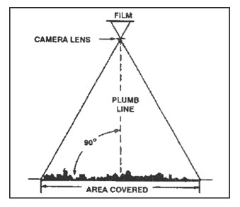
Fig. 7.1. Schematic diagram of taking a vertical photograph.
(Source: www.map-reading.com/aptypes.php)
A vertical photograph has the following characteristics:
(1) The camera axis is perpendicular to the surface of the earth.
(2) It covers relatively small area than oblique photographs.
(3) The shape of the ground covered on a single vertical photo closely approximates a square or rectangle.
(4) Being a view from above, it gives an unfamiliar view of the ground.
(5) Distance and directions may approach the accuracy of maps if taken over flat terrain.
(6) Relief is not readily apparent.
ii) Oblique photos: When the optical of the camera forms an angle of more than 50 with the vertical, oblique photographs are obtained (Fig. 7.2). The nadir and central point of the photograph are not coincident.
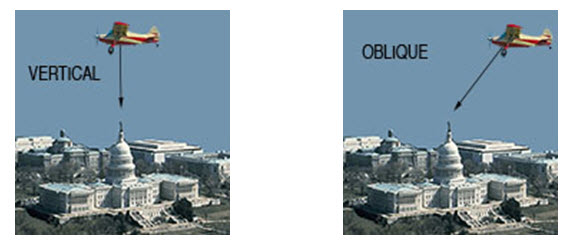
Fig. 7.2. Vertical and oblique photography.
(Source: fhf1.com/Aerial_Photography.html)
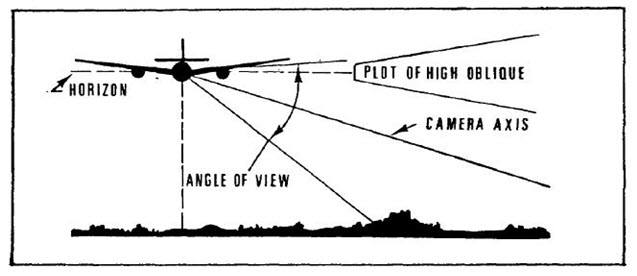
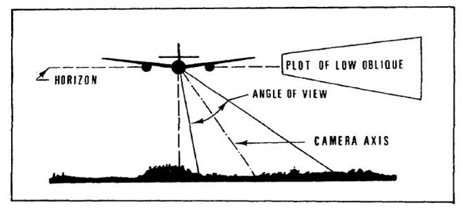
There are two types of oblique aerial photography – high angle and low angle. In high angle oblique aerial photography the resulting images shows the apparent horizon and in low angle oblique photograph does not. Oblique photographs can be useful for covering very large areas in a single image and for depicting terrain relief and scale.
(a)
(b)
Fig. 7.3. (a) High oblique and (b) low oblique photographs.
(Source: armyintelligence.tpub.com/IT0649/IT06490010.htm)
A square outline on the ground appears as a trapezium in oblique aerial photo. These photographs can be distinguished as high oblique and low oblique (Fig.7.3). But these are not widely used for mapping as distortions in scale from foreground to the background preclude easy measurements of distance, area, and elevation.
An oblique photograph has the following characteristics:
Low oblique photograph covers relatively small area than high oblique photographs.
The ground area covered is trapezoid, but the photograph is square or rectangular. Hence scale is not applicable and direction (azimuth) also cannot be measured.
The relief is discernible but distorted.
7.3 Basic Geometric Characteristics of Aerial Photographs
Aerial photographs are taken using a camera fitted at the bottom of a aircraft along a line is termed as flight line or flight strips and the line traced on ground directly beneath the camera is called nadir line. The point on photograph where the nadir line meets the ground is termed as principal point. Lines drawn to connect marks located along opposite sides of the photo (fiducial marks) intersect precisely at the principal point. The point on the photo that falls on a line half- way between the principal point and the Nadir point is known as isocenter. The ground distance between the photo centers (principal points) is called air base.
In aerial photography, the aircraft acquires a series of exposures along each strip of multiple flight lines. Successive photographs are generally taken with some degree of overlap, which is known as endlap (Fig. 7.4). Standard endlap is 60%, which may be 80-90% in special cases such as in mountainous terrain. It ensures that each point of the ground appears in at least two successive photographs essential for stereoscopic coverage. Stereoscopic coverage consists of adjacent pairs of overlapping vertical photographs called stereopairs. Beside endlap the photograph is taken with some overlap of photographs of a strip with the adjacent strip, known as sidelap (Fig 7.5). It varies from 20% to 30% to ensure that no area of the ground is missing out to be photograph.
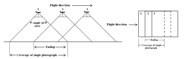
Fig. 7.4. Photographic coverage along flight line: endlap.
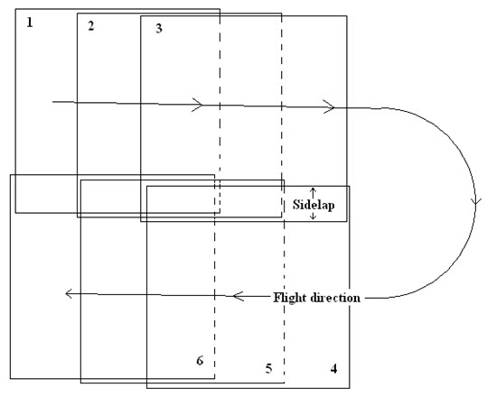
Fig. 7.5. Positions of aerial photos: sidelap.
A truly vertical photograph is rarely obtained because of unavoidable angular rotations or tilts, caused by the atmospheric conditions (air pockets or currents), human error of the pilot fails to maintain a steady flight and imperfections in the camera mounting. There are three kinds of tilts as it can be seen from Fig 7.6.
Tilting forward and backwards (pitch)
Tilting sideways (roll)
Tilting in the direction of flight (yaw)
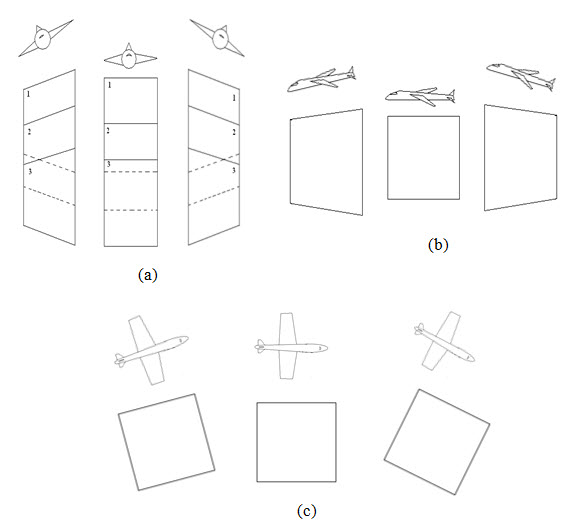
Fig. 7.6. (a) Roll, (b) Pitch, (c) Yow tilting of aircraft and corresponding ground coverage of aerial photograph.
In order to understand the geometric characteristics of an aerial photograph it is also necessary to understand the viewing perspective and projection. In case of viewing perspective on a map the objects and features are both planimetrically and geometrically accurate, because the objects and features is located in the same position relative to each other as they are on the ground or on the surface of earth. But there is a change in scale. On the other hand in aerial photography, central or perspective projection system is used as it can be seen from Fig 7.7. Therefore, there are not only changes in scale but also change in relative position and geometry between the objects depending on the location of the camera.
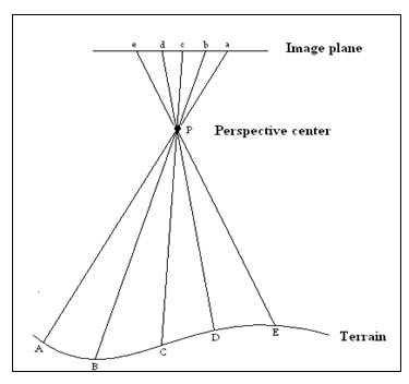
Fig. 7.7. Central or perspective projection.
Relief displacement: Relief is the difference in elevation between the high and low points of a feature or object. Due to central perspective projection system used in aerial photography, vertical objects standing above datum (average elevation) other than principal point lean outward and objects standing below the datum (average elevation) lean inward in an aerial photograph. This distortion is called relief displacement (Fig 7.8). An aerial photograph is a three-dimensional scene transferred onto a two-dimensional plane. Thus three-dimensional squashes literally due to lack of vertical dimension. Therefore image objects above and below mean ground level or datum are displaced from their true horizontal location or relief displacement takes place. Camera tilts, earth curvature, terrain relief, object height and object position in respect to principal point are the main causes of relief displacement. Relief displacement allows the measurement of objects height from a single photo or stereopair.
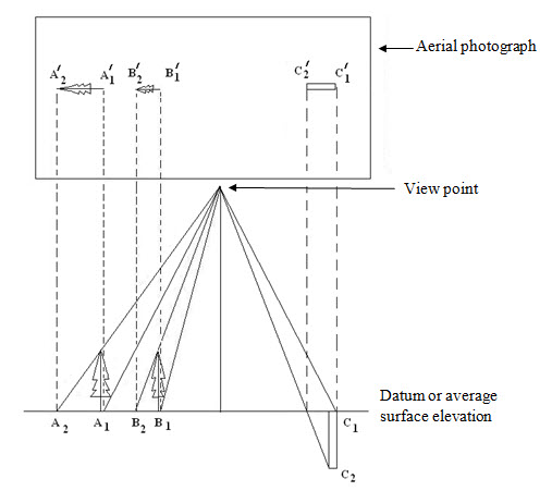
Fig. 7.8. Relief displacement in aerial photography.
Parallax: The term parallax refers to the apparent change in relative position due to change in viewing position. Objects near to the observer will move faster than the objects of far. When one views objects from the window of a moving train, objects nearer to the train will move faster than objects are at far. More details are available in lesson no. 8.
Orthophotos: (These are also referred as Orthoimages, which are the digital version of orthophotos) that has been orthorectified. They do not contain relief displacement, tilt, scale variation caused by different errors includes aircraft movement, camera tilt, curvature of earth, elevation changes in topography etc. Therefore like photos, orthophotos show actual detail and like maps they have only one scale.
7.4 Photographic Scale
The scale of a map or photograph is defined as the ratio of distance measured on the map to the same distance on the ground. The amount of detail in an aerial photograph depends on the scale of the photograph. Scales may be expressed as unit equivalents or dimensionless representative fractions and ratios. For example, if 1 mm on a photograph represents 25 m on the ground, the scale of the photograph can be expressed as 1mm =25m (Unit equivalents), or 1/25,000(representative fraction) or 1:25,000 (ratio).
A convenient way to clear confusion between large scale and small scale photograph is that the same objects are smaller on a small scale photograph than on a large scale photograph. For example, two photographs having scale 1:50,000 and 1:10,000. Aerial photo with scale 1:10,000 images shows ground features at a larger, more detailed size but less ground coverage than 1:50,000 scale photo. Hence, in spite of its smaller ground coverage, the 1:10,000 photos would be termed the large scale photo.
The most straightforward method for determining photo scale is to measure the corresponding photo and ground distances between any two points (Fig 7.9). The scale S is then computed as the ratio of the photo distance d to the ground distance D.
In the Figure 7.8 the triangle ∆Lab and ∆LAB are similar.
Hence, ao/AO=Lo/LO
or, d/D= f/H
S = d/D= focal length/flying height
where,
S= scale of photograph
d= distance in photograph
D= distance in ground
f= focal length
H= flying height
Hence Scale of a photo α focal length of camera (f)
α 1/flying height (H)
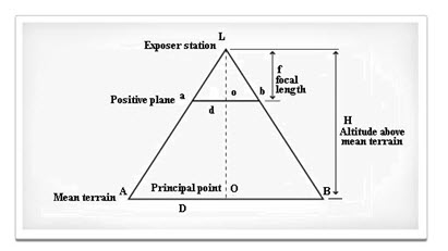
Fig. 7.9. Measurement of scale of an aerial photograph.
7.5 Ground Coverage of Aerial Photograph
The ground coverage of a photograph is, among other things, a function of camera format size. For example, an image taken with a camera having a 230×230 mm format (on 240 mm film) has about 17.5 times the ground area coverage of an image of equal scale taken with a camera having a 55×55-mm format (on 70-mm film) and about 61 times the ground area coverage of an image of equal scale taken with a camera having a 24×36-mm format (on 35-mm film). The ground coverage of a photo obtained with any given format is a function of focal length (f) and flying height above ground (H). The area covered in a photograph or ground coverage is inversely proportional to the scale of the photograph. Hence, for a constant flying height, the width of the ground area covered by a photo varies inversely with focal length and directly with flying height above terrain. Photos taken with shorter focal length lenses have larger areas of converge than taken with longer focal length lenses. On the other hand the ground coverage increases with increase in flying height.
Keywords: Aerial photograph, Vertical photograph, Oblique photograph, Photographic scale, Side lap, End lap.
References
armyintelligence.tpub.com/IT0649/IT06490010.htm
fhf1.com/Aerial_Photography.html
www.map-reading.com/aptypes.php
Suggested Reading
Bhatta, B., 2008, Remote sensing and GIS, Oxford University Press, New Delhi, pp. 214-238.
Girard, M. C., & Girard, C., 2003, Processing of remote sensing data, Oxford & IBH Publishing Co. Pvt. Ltd, pp. 255-277.
Lillesand, T. M., Kiefer, R. W., 2002, Remote sensing and image interpretation, Fourth Edition, pp. 136-137, 140.
Last modified: Tuesday, 21 January 2014, 6:09 AM