Site pages
Current course
Participants
General
Module 1: Introduction and Concept of Soil Erosion
Module 2: Water Erosion and Control
Module 3: Wind Erosion, Estimation and Control
Module 4: Soil Loss- Sediment Yield Estimation
Module 5: Sedimentation
Module 6: Topographic Survey and Contour Maps
Module 7: Land Use Capability Classification
Module 8: Grassed Waterways
Module 9: Water Harvesting
Module 10: Water Quality and Pollution
Module 11: Watershed Modeling
Keywords
Lesson 1 Introduction
1.1 Why Soil and Water Conservation?
Soil and water are two important natural resources and the basic needs for agricultural production. During the last century it has been observed that the pressure of increasing population has led to degradation of these natural resources. In other words increase in agricultural production to feed the increasing population is only possible if there sufficient fertile land and water are available for farming. In India, out of 328 million hectares of geographical area, 68 million hectares are critically degraded while 107 million hectares are severely eroded. That's why soil and water should be given first priority from the conservation point of view and appropriate methods should be used to ensure their sustainability and future availability. Status of global land degradation is shown in Fig. 1.1.
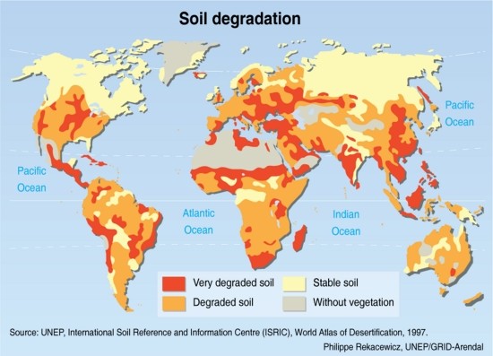
Fig. 1.1. Global soil degradation map.
(Source: UNEP, International Soil Reference and Information Centre (ISRIC), World Atlas of Desertification, 1997)
Water conservation is the use and management of water for the good of all users. Water is abundant throughout the earth, yet only three percent of all water is fresh water, and less than seven-tenths of freshwater is usable. Much of the usable water is utilized for irrigation. Detailed analysis will show that in about fifteen years, about two-thirds of the world’s population will be living in some sort of water shortage. Water is used in nearly every aspect of life. There are multiple domestic, industrial and agricultural uses. Water conservation is rapidly becoming a hot topic, yet many people do not realize the importance of soil conservation.
Soil conservation is defined as the control of soil erosion in order to maintain agricultural productivity. Soil erosion is often the effect of many natural causes, such as water and wind. There are also human factors which increase the rate of soil erosion such as construction, cultivation and other activities. Some may argue that since it is a natural process, soil erosion is not harmful. The truth is that with the removal of the top layer of soil, the organic matter and nutrients are also removed.
Conservation is not just the responsibility of soil and plant scientists, hydrologists, wildlife managers, landowners, and the forest or mine owner alone.
All citizens should be made aware about the importance of natural resources as our lives depend on that and everyone should be involved in the process of caring of these resources properly and using them intelligently.
1.1.1 What is Soil Erosion?
The uppermost weathered and disintegrated layer of the earth’s crust is referred to as soil. The soil layer is composed of mineral and organic matter and is capable of sustaining plant life. The soil depth is less in some places and more at other places and may vary from practically nil to several metres. The soil layer is continuously exposed to the actions of atmosphere. Wind and water in motion are two main agencies which act on the soil layer and dislodge the soil particles and transport them. The loosening of the soil from its place and its transportation from one place to another is known as soil erosion.
The word erosion has been derived from the Latin word ‘erodere’ which means eating away or to excavate. The word erosion was first used in geology for describing the term hollow created by water. Erosion actually is a two phase process involving the detachment of individual soil particle from soil mass, transporting it from one place to another (by the action of any one of the agents of erosion, viz; water, wind, ice or gravity) and its deposition. When sufficient energy is not available to transport a particle, a third phase known as deposition occurs. In general, finer soil particles get eroded more easily than coarse particles (silt is more easily eroded than sand). Hence soil erosion is defined as a process of detachment, transportation and deposition of soil particles (sediment). It is evident that sediment is the end product of soil erosion process. Sediment is, therefore, defined as any fragmented material, which is transported or deposited by water, ice, air or any other natural agent. From this, it is inferred that sedimentation is also the process of detachment, transportation and deposition of eroded soil particles. Thus, the natural sequence of the sediment cycle is as follows:
![]()
Detachment is the dislodging of the soil particle from the soil mass by erosive agents. In case of water erosion, major erosive agents are impacting raindrops and runoff water flowing over the soil surface. Transportation is the entrainment and movement of detached soil particles (sediment) from their original location. Sediments move from the upland sources through the stream system and may eventually reach the ocean. Not all the sediment reaches the ocean; some are deposited at the base of the slopes, in reservoirs and flood plains along the way. Erosion is almost universally recognized as a serious threat to human well being. Erosion reduces the productivity of crop land by removing and washing away of plant nutrients and organic matter. Distribution of global sediment load is presented in Fig. 1.2.
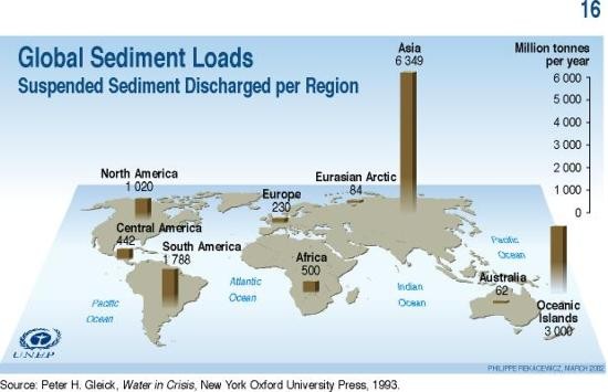
Fig. 1.2. Global sediment loads. Due to high monsoon rainfall, Asia has the highest suspended sediment discharge. (Source: Peter H.G., 1983)
1.1.2 Problems Arising due to Soil Erosion
Balanced ecosystems comprising soil, water and plant environments are essential for the survival and welfare of mankind. However, ecosystems have been disturbed in the past due to over exploitation in many parts of the world, including some parts of India. The resulting imbalance in the ecosystem is revealed through various undesirable effects, such as degradation of soil surfaces, frequent occurrence of intense floods etc.
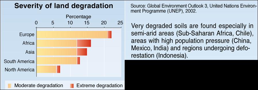
Fig. 1.3. Severity of land degradation at continental scale.
(Source: Peter H.G., 1983)
Vast tracts of land have been irreversibly converted into infertile surfaces due to accelerated soil erosion caused by the above and other factors. These degraded land surfaces have also become a source of pollution of the natural water. Deposition of soil eroded from upland areas in the downstream reaches of rivers has caused aggradation. This has resulted in an increase in the flood plain area of the rivers, reduction of the clearance below bridges and culverts and sedimentation of reservoirs. Severity of land degradation at a continental scale is shown in Fig. 1.3.
The major land degradation problems due to sedimentation are briefly discussed as below:
- Erosion by wind and water: Out of 144.12 M-ha areas affected by water and wind erosion. About 69 M-ha is considered to be critical and needs immediate attention. Wind erosion is mainly restricted to States of Rajasthan, Gujarat and Haryana. The severity of wind erosion is inversely related to the rainfall amount, lesser is the rainfall more would be the wind erosion.
- Gullies and Ravines: About 4 M-ha is affected by the problem of gullies and ravines in the country covering about 12 states. Ravines are mostly located in the states of Uttar Pradesh, Madhya Pradesh, Rajasthan and Gujarat. Gullies on the other hand are seen in the plateau region of Eastern India, foot hills of the Himalayas and areas of Deccan Plateau.
- Torrents and Riverine Lands: Problem of Riverine and torrents is spread over an area of 2.73 M-ha in the country. Torrents are the natural streams which cause extensive damage to life and property as a result of frequent changes in their course and associated flash flows with heavy debris loads. The unfertile material or debris transported by torrents is sometimes deposited on the fertile plains, thus ruining the land for ever.
- Water logging: Water logging is caused either by surface flooding or due to rise of water table. An area of 8.53 M-ha has been estimated to be affected by water logging. Water logging due to surface flooding is predominant in the states of West Bengal, Assam, Bihar, Orissa, Andhra Pradesh, Uttar Pradesh, Kerala, Punjab and Haryana.
- Shifting Cultivation: Shifting cultivation, also known as ‘jhuming’ is a traditional method of growing crops on hill slopes by slash and burn method. The method involves selection of appropriate site on hill slopes, cleaning of forest by cutting and burning, using the site for cultivation for few years and later on abandoning it and moving to a fresh site. The jhum cycle has gradually declined from 20-30 years to 3-6 years due to increasing population pressures. The problem is more serious in North Eastern region and in the states of Orissa and Andhra Pradesh.
- Saline soil including coastal areas: Saline soils are prevalent both in inland as well as coastal areas. About 5.5 M-ha area is affected by this problem in the country which includes arid and semi-arid areas of Rajasthan and Gujarat, black soil region and coastal areas. This problem is causing serious damage to agricultural lands, rendering fertile soil unproductive and turning groundwater brackish in the States of West Bengal, Tamil Nadu, Orissa, Maharashtra, Kerala, Karnataka, Gujarat and Andhra Pradesh as well as Union Territories of Pondicherry and Goa, Daman and Diu.
- Floods and Droughts: In India, among the major and medium rivers of both Himalayas and non-Himalayas catagories, 18 are flood prone which drain an area of 150 M-ha. In recent years, flash floods have caused extensive damage even in the desert areas of Rajasthan and Gujarat.
1.1.3 Importance of Soil Conservation
In India, out of the total geographical area of 329 M-ha, an area of about 150 M-ha is subjected to either water or wind erosion. A net area of about 140 M-ha is cropped at present. An area of 40 M-ha is considered to be flood prone. Area lost through ravines and gullies is estimated to be about 4 M-ha. As a whole, it is estimated that about 175 M-ha i.e., 53.3% of the total geographical area of the country is subjected to various soil and land degradation problems like saline-alkali soils, waterlogged areas, ravine and gullied lands, area under shifting cultivation, and desertification. By the year 2100 A.D, the projected population of the country is expected to be two billion, whereas the food grain production is almost stagnant at 211 million tons for the last 5 years. The per capita cropped area is shrinking every day; in the year 1950, it was 0.33 ha/capita, 0.2 ha in 1980 and it was 0.15 ha by 2000. This clearly shows that the limited land resource has to be managed very carefully by adopting total conservation measures for the survival of the huge population. A few suggestions to conserve soil and water resources in Indian context are discussed below.
- To prevent erosion of bare soil, it is important to maintain a vegetation cover, especially in the most vulnerable areas e.g. those with steep slopes, in a dry season or periods of very heavy rainfall. For this purpose, only partial harvesting forests (e.g. alternate trees) and use of seasonally dry or wet areas for pasture rather than arable agricultural land should be permitted.
- Where intensive cultivation takes place, farmers should follow crop rotation in order to prevent the soil becoming exhausted of organic matters and other soil building agents. Where soils are ploughed in vulnerable areas, contour ploughing (i.e. round the hillside rather than down the hillside) should be used. Careful management of irrigation, to prevent the application of too much or too little water will be helpful to reduce the problem of soil salinity development. Livestock grazing must be carefully managed to prevent overgrazing.
- Construction of highways and urbanization should be restricted to areas of lower agricultural potential. With extractive industries, a pledge must be secured to restore the land to its former condition before permission for quarries or mines is granted.
1.1.4 History of Soil Erosion and Soil Conservation Programs in India
To meet the demand for food, fiber, fuel wood and fodder owing to increasing population pressures, the forest areas have been indiscriminately cleared resulting in enormous soil loss in many parts of the country. The human activities such as urbanization, road construction, mining etc. have further aggravated the problem. In the early years, the problem was more localized but now it has become more serious due to over exploitation of natural resources. However, various governmental plans have been implemented in the field of conservation of land, water and plant resources since pre-independence days.
(1) The Pre-Independence Era
In 1882, Sir Dietrich Brands, the Inspector General of Forests, commented on the possibility of soil erosion taking place and the need to counter it in the denuded slopes of the Nilgiri District of Madras Province of pre-independence India. He suggested planting of belts of trees in the midst of cultivation on hill slopes. Protection of land from the menace of ‘Cho’ (mountain torrents) also received early attention and one of the first enactments for prevention of soil deterioration was passed in Punjab in 1900 as Land Preservation Act. It provided for such measures as Wat Bandi (ridge formation), contour trenching, gully plugging, terracing, tree planting etc. for preventing the havoc caused by Chos. Soil conservation research in India was initiated during 1933-35 when the then Imperial (now Indian) Council of Agricultural Research decided to establish its regional centres for research in dry farming at Sholapur (Maharashtra), Bijapur, Raichur, Bellary (Karnataka) and Rohtak (Haryana). Holding rain water by construction of bunds, green manuring, cultivation of kharif crops on shallow soils and fallowing in deep black soils were important measures recommended by the research stations.
A real push to soil conservation was given when a separate Soil Conservation Wing in Agricultural Department was established in Maharashtra during 1940’s and massive contour bunding programme was taken up following scientific guidelines and specifications. Field bunding was also practiced as part of famine relief programmes in the Deccan plateau during 1930’s and 40’s. Soil conservation was not confined to contour bunding alone but also included nala bunding (check dams of loose stones) and percolation dams for water harvesting.
A commission was appointed by the Gwalior State as far back as 1919 to consider ways and means of arresting further extension of ravines and suggest methods for improving production of economic plants in these areas. In the 1930’s, ravine reclamation practices were applied in the Chambal ravines of the erstwhile state of Gwalior. In 1953, Board of Agriculture made a proposal for a systematic reconnaissance survey of Indian soils to assess the damage caused by erosion. The Bombay Land Improvement Act of 1942 provided for setting up in each division a Land Improvement Board for conservation, improvement and regulation of agriculture, forest and pasture lands.
In 1945, the Central Government obtained the services of Dr. Donald V. Shuhart of Soil Conservation Service, USDA to report on soil erosion problems in India and suggest remedial measures. A high powered seven member team visited United States in May, 1947 for exhaustive study of soil conservation practices and submitted a report to Government of India taking due cognizance of the conditions peculiar to the Indian Agriculture. The team suggested that the unit of planning should be a village or a group of villages or a watershed. The report also emphasized that there should be a close cooperation between the Department of Forest, Agriculture and Irrigation at the centre and in the provinces in initiating and developing different phases of the conservation programme.
(2) Post-Independence Period
A conference of state Ministers in-charge of agriculture and cooperation was held in New Delhi in September, 1953. The conference considered that at the state level, existing organizations and state development committees should be entrusted with the task of formulating soil conservation programmes. It also suggested that any state problem with regard to soil conservation should be concern of the Central Soil Conservation Board. The central Government in the Ministry of Food and Agriculture set up a Central Soil Conservation Board in 1953. Maharashtra state did pioneering work on problems of soil erosion and conservation measures in cultivated lands. It was realized that ultimate aim of soil conservation was not only to control erosion but also to maintain the productivity of soil.
(3) First Five Year Plan (1951-56)
During the First Five Year Plan (1951-56), considerable attention was given to soil and moisture conservation. With a view to develop a research base for soil conservation, a Soil Conservation Branch and a Desert Afforestation Research Station at Jodhpur were established under the control of Forest Research Institute, Dehra Dun. Consequently, the Central Soil Conservation Board established a chain of nine Soil Conservation Research, Demonstration and Training Centers at Dehra Dun, Chandigarh, Bellary, Ootacamund (now Udhagamandalam), Kota, Vasad, Agra, Chatra (Nepal) and Jodhpur during the late First Five Year Plan and early Second Five Year Plan.
(4) Second Five Year Plan (1956-61)
In this plan, the Desert Afforestation and Soil Conservation Centre at Jodhpur were developed into the Central Arid Zone Research Institute (CAZRI) in 1959 with collaboration of UNESCO. A Centre was set up at Chatra in Nepal to take-up research on soil conservation problems of Kosi River Valley Project. The All India Soil & Land Use Survey Organization was established at central level.
(5) Third Five Year Plan (1961-66)
A centre at Ibrahimpatnam (Hyderabad) in the semi-arid red soil region was established in the third five year plan in 1962. The Government of India reorganized the Soil Conservation Division in the Ministry of Agriculture and redesignated the Senior Director as Advisor and entrusted him with the responsibility of coordinating the soil and water conservation development. After the reorganization of Agricultural Research and Education in India, all the Soil Conservation Research, Demonstration and Training Centres of the Government of India except Chatra (Nepal) were transferred to the Indian Council of Agricultural Research (ICAR) on the 1st October, 1967.
(6) Fourth Five Year Plan (1969-74)
Under this plan, All India Soil & Land Use Survey prepared a detailed analysis of different watersheds of the country. The concept of Integrated Watershed Management was successfully introduced at field level in different parts of the country.
(7) Fifth Five Year Plan (1974-79)
In this plan, the Government of India introduced many centrally sponsored programmers, viz; Drought Prone Area Programme (DPAP), Flood Prone Area Programme (FPAP), Rural Development Programme (RDP), and Desert Development Programme (DDP). In DPAP and DDP, the focus was on planting of trees on degraded lands and to drill tube wells to extract groundwater.
(8) Sixth Five Year Plan (1980-85)
In this plan period, more emphasis was given on the treatment of small watersheds varying in size up to 2000 hectare. An intensive programme for integrated management of about 200 sub-watersheds of 8 flood prone catchments of Ganga river basin was undertaken during this plan.
(9) Seventh Five Year Plan (1985-90)
In this plan, DDP in hot and cold desert areas took a major establishment and aforestation practices were adopted on a large scale following integrated watershed management approach. On the basis of the experience gained in various schemes, National Watershed Development Programme for Rainfed Areas (NWDPRA) was launched in the 7th Plan in 99 selected districts in the country. NWDPRA was implemented in about 2550 watersheds in 357 districts of 25 states and two Union Territories, viz; Andaman and Nicobar Islands and Dadra and Nagar Haveli. The watershed approach has the advantage of serving the twin objectives of restoration of ecological balance and socio-economic welfare of watershed community.
(10) Eighth Five Year Plan (1990-95)
During this period, Ministry of Agriculture, Department of Agriculture and Cooperation, New Delhi formulated the guidelines for the implementation of NWDPRA and published it in the form of a document commonly known as WARASA (Watershed Areas Rainfed Agriculture System Approach). The Ministry of Rural Development also brought out common guidelines for the implementation of DPAP, DDP and Integrated Wasteland Development Programme (IWDP) in the country so as to maintain uniformity in objectives, strategies and expenditure norms for various watershed development projects.
(11) Ninth Five Year Plan (1997-02)
The centrally sponsored scheme for reclamation of alkali soils was launched during the Seventh Five Year Plan in the states of Haryana, Punjab and Uttar Pradesh. It continued during the Eighth Five Year Plan and was extended to the states of Gujarat, Madhya Pradesh and Rajasthan. During 2000-01, it was extended to all other states where alkali soil problem exists. The scheme aimed at improving physical conditions and productivity status of alkali soils for restoring optimum crop production. The major components were assured irrigation water, on-farm development works like land leveling, bunding and ploughing, community drainage system, application of soil amendments, organic manures etc. During IX Plan, an area of 0.97 lakh ha, mostly occurring in isolated patches, was reclaimed at a cost of Rs. 14.99 crores (Govt. of India share).
Up to IX plan (1997-02), an area of 426 lakh ha had been covered under Priority Delineation Survey (PDS) and about 13.1 lakh ha under Detailed Soil Survey (DSS) by the All India Soil and Land Use Survey.
(12) Tenth Five Year Plan (2002-07)
The Tenth Five Year Plan (2002-2007) has put emphasis on natural resource management through rainwater harvesting, groundwater recharging measures and controlling groundwater exploitation, watershed development, treatment of waterlogged areas. The Government of India fully funded the Western Ghats Development Programme (WGDP), area affected due to erosion and water problem. In this programme, the State Governments were directed to adopt Integrated Watershed Approach in implementing the activities such as soil conservation, agriculture, horticulture, afforestation, fuel and fodder development, minor irrigation, animal husbandry etc. various soil conservation measures (engineering and agricultural) like construction of check dams, gully plugging, plantation of mixed species and contour trenching etc were taken up in sensitive Western Ghats areas of Sattari, Canacona and Sanguem talukas.
(13) Eleventh Five Year Plan (2007-12)
Watershed development projects, for the purpose of conserving soil and water, were funded through various schemes including National Watershed Development Projects in Rainfed Areas (NWDPRA), River Valley Projects (RVP), and Integrated Wasteland Development Programme (IWDP). Emphasis has been given to increase the water resources availability and their efficient use. Responsibility for ensuring adequate availability of water for agricultural use was divided between the Ministry of Water Resources (MoWR), which was responsible for major, medium, and minor irrigation, the Department of Land Resources, which was responsible for watershed management, the Department of Rural Development, which was responsible for the Mahatma Gandhi Rural Employment Guarantee Act (MGNREGA) and strongly oriented to deal with water conservation issues, and the Department of Agriculture, which deals with water use efficiency.
References
-
UNEP, International soil reference and information centre (1997). World atlas of desertification.
-
Peter H.G. (1983). Water in crises, New York Oxford University.
-
UNEP (2002). Global environmental outlook, united programme.
Suggested further readings
-
Das, G. (2000). Hydrology and Soil Conservation Engineering, Prentice Hall of India, New Delhi, India.
-
Murty, V.V.N. and Jha, Madan K. (2011). Land and Water Management Engineering, Kalyani Publishers, India.
-
Sharda, V.N., Juyal, G.P., Prakash, C. and Joshi, B.P. (2007). Soil And Water Conservation Engineering (Training Manual-volume II), CSWCRTI, Dehradun, India.
-
Subramanya, K. (2010). Engineering Hydrology, 3rd ed. Tata McGraw-Hill, New Delhi, India.
Last modified: Monday, 16 December 2013, 6:56 AM