Site pages
Current course
Participants
General
Module.1 Introduction of Water Resources and Hydro...
Module.2 Precipitation
Module.3 Hydrological Abstractions
Moule.4 Types and Geomorphology of Watersheds
Module 5. Runoff
Module 6. Hydrograph
Module 7. Flood Routing
Module 8. rought and Flood Management
Lesson 3 Introduction to Hydrology
3.1 Definition of Hydrology
Hydro means water, and logy means study. Therefore, in a broad sense hydrology can be defined as a study of water. A more practical definition is given below:
Hydrology can be defined as the science as the science that deals with the space-time characteristics of the quantity and quality of the waters of the earth, encompassing their occurrence, movement, distribution, circulation, storage, exploration, development, and management. These characteristics are determined by the relation of water to the earth.
The definition of hydrology encompasses some aspects of a multitude of disciplines involving agriculture, biology, chemistry, geography, geology, glaciology, meteorology, oceanography, physics, volcanology and many other disciplines. Many branches of hydrology have been distinguished (Fig. 3.1) because of the close association of water with the atmosphere and the earth.
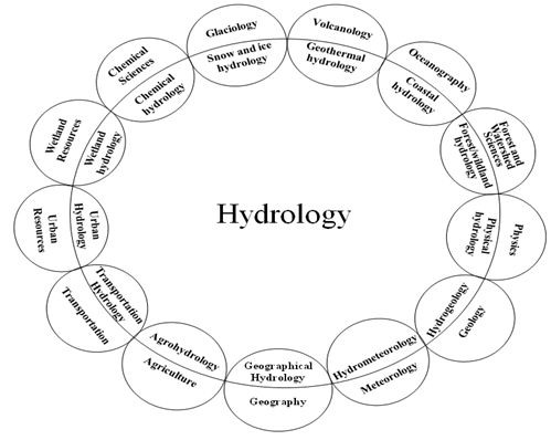
Fig.3.1.Classification of hydrology according to its association with other branches of science. (Source: Singh, 1994)
The techniques for solving hydrologic problems are borrowed from several disciplines such as mathematics, statistics, probability theory, operation research, control theory, information theory, and others. Based on the treatment of hydrologic data by these techniques, hydrology can be sub-divided into different branches (Fig 3.2).
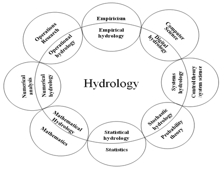
Fig. 3.2.Classification of hydrology according to methods of solution.(Source: Singh, 1994)
3.2 Hydrologic Cycle
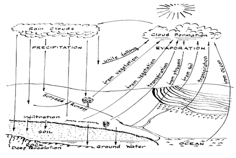
Fig. 3.3.Descriptive representation of the hydrologic cycle.
(Source: Ackermann et. al., 1955)
Water on the earth exists in a space called the hydrosphere which extends about 15 km into the atmosphere and about 1 km down into the lithosphere, the crust of earth. Water circulates in the atmosphere through maze of paths constituting the hydrologic cycle. This cycle has no beginning or end, and many processes (known as hydrological processes) occur continuously. A schematic of hydrologic cycle is given in Fig. 3.3.
Water evaporates from the water bodies (lakes, rivers, oceans and other free water bodies), land surface, and transpires from vegetation (forests, cropland and other vegetation) due to the energy from the sun, thereby providing supply of vapor to the atmosphere. Water vapor is transported and lifted in the atmosphere until it condenses and precipitates on the land or oceans; precipitated water may be intercepted by vegetation, become overland flow over the ground surface, infiltrate into the ground, flow through the soil as subsurface flow, discharge into streams as surface runoff. Much of the intercepted water and surface runoff returns to the atmosphere through evaporation and transpiration. The infiltrated water may percolate deeper to recharge ground water, later emerging as springs or seeping into streams to form surface runoff, and finally flowing to the sea or evaporating into the atmosphere as the hydrologic cycle continues.
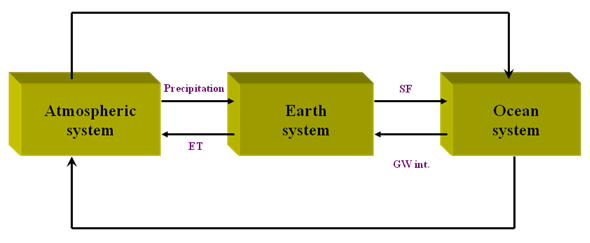
Fig. 3.4.A global schematic of the hydrologic cycle.(Source: Singh, 1994)
Figs. 3.4 through 3.7shows hydrologic cycle at global scale and various hydrologic processes involved in the earth and land systems. The concept of the hydrologic cycle is simple, but the phenomenon is enormously complex and intricate. It is not just one large cycle but rather is composed of several interrelated cycles of continental, regional, and local extent.
Furthermore, the total volume of water in the global hydrologic cycle remains essentially constant (conservation of mass), the distribution of this water is continually changing in both space and time.
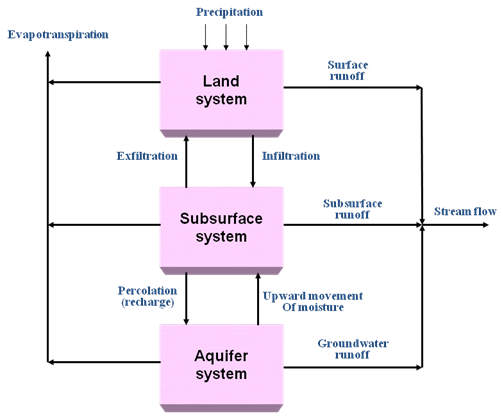
Fig. 3.5.A schematic of the hydrologic cycle in the earth system.
(Source: Singh, 1994)
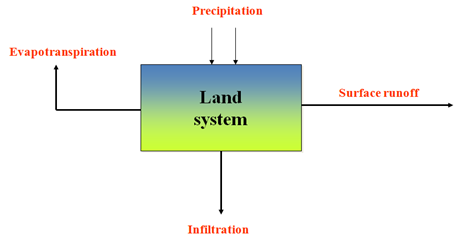
Fig. 3.6.A schematic of the hydrologic cycle in the land system.
(Source: Singh, 1994)
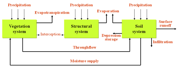
Fig. 3.7.A more complete schematic of the hydrologic cycle in the land system.(Source:Singh, 1994)
The hydrology of a region is determined by its weather patterns and by physical factors such as topography, geology, and vegetation. Also, as civilization progresses, human activities gradually encroach on the natural water environments, altering the dynamic equilibrium of the hydrologic cycle and initiating new processes and events.
3.3 Applications of Hydrology
The most important uses of hydrology are flood control, drought mitigation, water supply, pollution control, urban and industrial development, design of hydraulic works, agricultural production, land conservation, environmental impact assessment, land use change, navigation, recreation and fisheries.
3.3.1 Flood Control
Floods occurs when
- water body (lake, reservoir, or channel) is unable to contain the amount of the water it receives,
- there is inadequate drainage provision to drain excess water, and
- Hydraulic structures such dams, levees and dykes are failed.
The hydrologic inputs needed to design flood mitigation and control projects (structural, e.g. dams, levees, diversions, channels, and non-structural e.g. flood plain management, flood roofing or both) includes:
- Peak discharge and its frequency of occurrence,
- Duration and volume of flood hydrograph and their probability of occurrence, and
- Arrival of next flooding.
3.3.2 Drought Mitigation
Drought occurs when there is a shortage of water by comparison with the demand for it. Droughts are usually distinguished as agricultural, hydrological and meteorological. The problem of drought is defined by its areal extent, duration, severity, and the onset of next drought. From hydrological perspective, low discharge (defined over a period) and its frequency of occurrence, duration and volume of low flow, and the probability of occurrence of the next drought are useful to design drought mitigation projects.
Construction of water impoundments, ground water pumpage, interbasin transfer, water conservation, and even augmentation of atmospheric precipitation through cloud seeding are some of the ways to mitigate droughts.
1. Design of Hydraulic Works
Dams, culverts, spillways, bridge crossings, dykes, levees, diversions, drainage works etc. are typical hydraulic works required for water resources development and management. Design of these works requires an estimate of peak discharge of given frequency. Also estimated using hydrology is the environmental consequence of these works.
2. Agricultural Production
Agriculture is the largest water user and for sustainable agricultural production efficient water management is essential. Proper agricultural practices conserve precipitation for crop use, prevent the loss of precious soil, and preserve the quality of stream that drains the land. Crop production involves moisture forecasting, supply of water to farms, management of irrigation water, application of chemical and fertilizers, drainage of excess water, soil conservation etc.
Hydrology is used to determine irrigation scheduling, soil erosion and sediment transport, migration of chemical and their impact on water quality. It also used to design a network of wells for a farm, drainage system to remove excess water, and water conveyance system network (dams, canals, and ditches) based on soil properties, land slope, location of the water table, climate and other factors.
3. Land Conservation
Careless farming method, deforestation, over-grazing can speed up runoff of rainfall, resulting in erosion of soil. This increases the danger of flooding downstream and also increases reservoir sedimentation rate. Loss of fertile lands due to erosion and of coastal areas has been growing concern.
Hydrology is used to determine the space-time history of erosion and to develop scenarios for prevention of erosion through, soil conservation, appropriate farm practices, vegetation management, water diversion, afforestation, reduced flooding and controlled land use.
References
Singh, V. P. (1994). Elementary Hydrology.Prentice Hall of India Private Limited,New Delhi.
Ackerman, W. C., Colman, E. A. andOgrasky, H. O.(1955). From Ocean to Sky to Land to Ocean, Water, the Yearbook of Agriculture, USDA, pp. 41-51.
Suggested Reading
Suresh R. (2007). Soil and Water Conservation Engineering.Fourth edition, Standard Publishers Distributors, New Delhi.
Subramanya, K. (1994). Engineering Hydrology.Third edition, Tata McGraw Hill, New Delhi.
Murty, V.V.N. and Jha, M.K. (2009).Land and Water Management Engineering.Fifth edition, Kalyani Publishers, Ludhiana.
Last modified: Saturday, 1 March 2014, 11:11 AM