Site pages
Current course
Participants
General
Module 1 - Water availability and demand and Natio...
Module 2 - Irrigation projects and schemes of India
Module 3 - Concepts and definitions
Module 4 - Command Area Development and Water Mana...
Module 5 - On-Farm-Development works
Module 6 - Water Productivity
Module 7 - Tank & Tube well irrigation
Module 8 - Remote Sensing and GIS in Water Management
Module 9 - Participatory Irrigation Management
Module 10 - Water Pricing & Auditing
LESSON 10. Concepts And Definitions Related To Command Areas
10.1 IRRIGATION
Irrigation is the artificial application of water at right time and in required quantity to the root zone of the crop for the purpose of getting optimum yield.
10.2 DUTY OF WATER (d ha/cumec)
This is defined as the area that can be irrigated with a continuous non-stop supply of irrigation water at the rate of one cumec or cusec throughout the base period. It is expressed as acre/cusec or hectare/cumec.
10.3 BASE PERIOD (B days)
This is the period over which irrigation water is to be supplied for the production of any crop. Normally this is equal to the period between the first and last irrigation to a crop.
10.4 DELTA (∆ cm)
This the depth of water required by a crop during the crop season to meet its requirements. This dies not have any relevance to the area of the cropped field. It is expressed in mm or cm.
10.5 RELATIONSHIP BETWEEN DUTY, DELTA AND BASE PERIOD
Let ∆ be the depth of irrigation water required by a crop in cm
B be the base period in days
d be the duty of water in ha/cumec.
Then, \[\Delta= \frac{{864B}}{d}\]
This is the relationship between duty, delta and base period.
10.6 IRRIGATION EFFICIENCIES
In irrigation systems also there is difference between the input and output at different stages. The important irrigation efficiencies are,
10.6.1 CONVEYANCE EFFICIENCY (Ec)
Water is conveyed through conveyance structures like main canal, branch canal, major distributory, minor distributory, field channels and watercourses. These structures may be lined or unlined. During conveyance of irrigation water in these structures loss occurs due to seepage, evaporation and percolation and hence resulting in variation between input and output between the regulator and field gate.
10.6.2 APPLICATION EFFICIENCY
Especially in a canal system, the entire water let into the field are not retained due to the terrace system of irrigated field. When a block of fields is considered, some of the water let in is drained as runoff in to field drains. This runoff may be useful for further irrigation of subsequent next block of fields or may not be useful for irrigation. For the block under consideration, the applied water is lost as run off. Hence application efficiency comes into the picture. In case of well irrigation, application efficiency is generally 100%. In case considerable water is lost due to deep percolation resulting from over irrigation, water drained below the root zone and not available for crops is to be accounted as run off.
10.6.3 STORAGE EFFICIENCY
Irrigation water applied is stored in the root zone of the cropped field. Irrigation is needed to fill the moisture depleted in the root zone prior to irrigation. When there is difference between the irrigation water applied and retained in the field (VR) and irrigation water needed prior to irrigation (VN), the storage efficiency comes into the consideration. The volume retained (VR)is arrived at by deducting the runoff from the volume applied into the field. Irrigation water needed prior to irrigation (VN) is computed from the soil properties of field capacity (FC), wilting point (WP), Bulk density (BD), Root zone depth (D) and percentage of Soil Moisture Available (SMA) in the field prior to irrigation and area of the field (A).
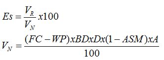
where,
Es = Storage efficiency in %
VR = Volume of irrigation water retained in the field in m3
VN = Irrigation water needed prior to irrigation in m3
FC = Field capacity in %
WP = Wilting point in %
BD = Bulk density in g/cc
D = Root zone depth in m
ASM = Available Soil Moisture prior to irrigation in fraction
A = Area of the field in m2
10.6.4 DISTRIBUTION EFFICIENCY
The applied irrigation water in any irrigation field and in any irrigation system will not get uniformly distributed and deposited in the root zone at all points. There will be variation in actual depth of application of irrigation water. The measure of how effectively the irrigation water is distributed in any method of application is given by distribution efficiency (Ed). It is also referred to as Christiansen’s Uniformity co-efficient(Cu). It is given by the formula,
Ed = [1-(Ŷ/đ)] x 100
Where,
Ed = Distribution efficiency in %
Ŷ = Mean deviation from the mean depth of application in cm
đ = Mean depth of application in cm
If depth of application is measured at N points, then the mean depth of application is the average of these N values. The mean deviation is the average of deviation of each depth observed from the mean value computed.
10.6.5 CROP WATER USE EFFICIENCY
This is defined as yield of the crop per unit of water consumed for its evapotranspirative requirements. Experimentally it can be found out by conducting lysimeter studies. It is expressed as kg/m3.
10.6.6 FIELD WATER USE EFFICIENCY
This is the practically used value. This is defined as yield of the crop per unit of water consumed for its total requirements. Experimentally, it can be found out by measuring the volume of water let into any cropped field over one season. It is expressed as kg/m3.
10.6.7 PROJECT EFFICIENCY
This is the efficiency with which the water available in any project/ dam/ tank/ any other water resource is used. It is the ratio of the volume of water used for the purpose of crop production to volume of water delivered from the project for this purpose. If the conveyance and distribution losses are low than this efficiency will be good. Most of the Indian projects operate with an efficiency of about 40 to 60 % only.
10.7 DRAINAGE
Drainage is defined as the artificial removal of water from the cropped fields within the tolerance limit of the crops grown in the area under consideration.
Drainage problem may be caused by excess rain fall or by over irrigation of upper fields or by the raising ground water table. The excess rain/irrigation water will normally drain in to the lower fields by the action of gravity. When the lower fields does not have proper drainage facility water logging condition occurs. Presence of ground water table in the root zone affects the growth of roots. The tolerance limit of the crops varies with their physiological characters.
Paddy is likely to tolerate submergence for a week or so whereas many field crops have a tolerance of about one to three days. Drainage is also required for special requirements like leaching and reclamation of problem soils. Salt affected soils are to be amended with chemicals and the diluted salts are to be leached by stagnating water in the field and then draining them by surface or subsurface drainage system.
10.8 DRAINAGE CO-EFFICIENT is defined as the depth of water to be removed within 24 hours over the area under consideration. This parameter helps in designing the rate of flow and the size of the drainage channel or pipe.
10.9 AQUIFER
A permeable stratum or a geological formation of a permeable material, which is capable to yield appreciable quantities of ground water under gravity, is known as an Aquifer. Different types of aquifers are
10.9.1 Unconfined Aquifer or Non-Artesian Aquifer: An unconfined Aquifer is one which is not confined by an upper impermeable layer. It is also known as water table aquifer. Water in these aquifers is at atmospheric pressure. Jl1e upper surface of the zone of saturation is known as water table. When a well is constructed in these aquifers the level of the water table is the level of water in the well.
10.9.2 Confined Aquifers or Artesian Aquifers: When an aquifer is confined on both sides by impervious rock formations i.e. aquicludes, and is also broadly inclined so as to expose the aquifer somewhere to the catchment area or recharge area at a higher level for the creation of sufficient hydraulic head, it is called a confined aquifer or an artesian aquifer. Water in these aquifers is under pressure above atmospheric pressure. When a well is put in these aquifers water will rise to a level above the water table of the upper confining layer because of the pressure under which the water is held. The imaginary level to which water will rise in wells located in an artesian aquifer is known as the piezometric level. Should the piezometric surface lie above ground surface, a flowing (artesian) well results.
10.9.3 Perched Aquifer: Perched aquifer occurs whenever a ground water body is separated from the main groundwater by a relatively impermeable stratum of small aerial extent.
10.10 WATER TABLE: The upper most surface of water available below the ground under atmospheric pressure.
10.11 WELLS
A well is a hydraulic hole excavated or drilled in the earth crust down to the supply of water for the purpose of bringing it to the ground with suitable lifting device. A water well consists essentially a pit, shaft or a bore constructed in the earth with the purpose of abstracting groundwater.
10.12 LAKE
A lake is a body of relatively still fresh or salt water of considerable size, localized in a basin, that is surrounded by land apart from a river, stream, or other form of moving water that serves to feed or drain the lake. Lakes are inland and not part of the ocean and therefore are distinct from lagoons, and are larger and deeper than ponds. Lakes can be contrasted with rivers or streams, which are usually flowing. However most lakes are fed and drained by rivers and streams. Many lakes are artificial and are constructed for industrial or agricultural use, for hydro-electric power generation or domestic water supply, or for aesthetic or recreational purposes.
10.13 TANK
In India, an irrigation tank or tank is an artificial reservoir of any size. (The word sagar refers to a large lake, usually man-made). It can also have a natural or man-made spring included as part of a structure. Tanks are part of an ancient tradition of harvesting and preserving the local rainfall and water from streams and rivers for later use, primarily for agriculture and drinking water, but also for sacred bathing and ritual. Often a tank was constructed across a slope so to collect and store water by taking advantage of local mounds and depressions. Tank use is especially critical in parts of South India without perennial rainfall where water supply replenishment is dependent on a cycle of dry seasons alternating with monsoon seasons.
Tanks known as "Pushkarni" or "Kalyani" also known as "Kund" in Hindi are reservoirs with steps leading down to the water, generally found in South India, and sometimes constructed within the walls of a temple complex. Bathing in the sacred waters of a temple tank was believed to cure worshippers of afflictions such as leprosy and blindness. Many temple tanks are decaying and drying up today.
There is considerable uncertainty about defining the difference between lakes and ponds, and no current internationally accepted definition of either term across scientific disciplines or political boundaries exists. For example, limnologists have defined lakes as water bodies which are simply a larger version of a pond, which can have wave action on the shoreline or where wind-induced turbulence plays a major role in mixing the water column. None of these definitions completely excludes ponds and all are difficult to measure. For this reason there has been increasing use made of simple size-based definitions to separate ponds and lakes. One definition of lake is a body of water of 2 hectares (5 acres) or more in area, however others have defined lakes as waterbodies of 5 hectares (12 acres) and above, or 8 hectares (20 acres) and above. Charles Elton, one of the founders of ecology, regarded lakes as waterbodies of 40 hectares (99 acres) or more. The term lake is also used to describe a feature such as Lake Eyre, which is a dry basin most of the time but may become filled under seasonal conditions of heavy rainfall. In common usage many lakes bear names ending with the word pond, and a lesser number of names ending with lake are in quasi-technical fact, ponds.
10.14 POND
A pond is a body of standing water, either natural or man-made, that is usually smaller than a lake. They may arise naturally in floodplains as part of a river system, or they may be somewhat isolated depressions (examples include vernal pools and prairie potholes). Usually they contain shallow water with marsh and aquatic plants and animals. A few animals also make ponds, including both alligators and beavers. The type of life in a pond is generally determined by a combination of factors including water level regime (particularly depth and duration of flooding) and nutrient levels, but other factors may also be important, including presence or absence of shading by trees, presence or absence of streams, effects of grazing animals, and salinity.
Humans also make ponds. A wide variety of man-made bodies of water are classified as ponds. Some ponds are created specifically for habitat restoration, including water treatment. Others, like water gardens, water features and koi ponds are designed for aesthetic ornamentation as landscape or architectural features. Fish ponds are designed for commercial fish breeding, and solar ponds designed to store thermal energy. Standing bodies of water such as puddles, ponds, and lakes are often categorized separately from flowing water courses, such as a brook, creek, or stream.
Tobha is Punjabi name for village pond. Every village in Punjab (India) essentially has a pond, into which the drainage of village is forced. Buffalos and other village animals take bath in village pond during summers. Tobha also provide recreation for village people, where children also learn to swim and play.
10.15 SYSTEM TANK
System tank is one which receives water directly from a canal system, drainage water from upper command area and from its own catchment and irrigates a command area of its own. A chain of hundreds of system tanks are present in Periyar-Vaigai command area in Tamil Nadu resulting in better total water management. However, the direct (ayacut) command area has the priority in water supply over the system tanks.
10.16 NON-SYSTEM TANK
Non system tanks are rainfed tanks having independent catchment and command area. The area irrigated is proportional to the amount and distribution of rain fall received and stored. The tail end farmers has lesser priority over the head end farmers. They are governed by local panchayats in general.
10.17 CONTOUR CANAL
The canal constructed along the contour especially across the slope in the hills to convey water. They can supply water to only one side of the canal by gravity i.e.: area below the canal only.
10.18 RIDGE CANAL
The canal constructed along the ridge line along the slope to convey water. They can supply water to either side of the canal by gravity.
10.19 CULVERT
The structure with single span constructed across a water course to facilitate crossing of farm roadsm when the water level is below the road level. The culverts are constructed with stone or concrete slabs and RCC pipes depending on the site conditions.
10.20 INVERTED SYPHON
The structure with two wells on either side connected by a buried pipe line. This is constructed when two water courses cross each other and their water levels intersect without the structure. This structure is constructed where there is lower flow of the two water courses. Also this structure is constructed when the water level in the canal intersects with road level. The water is taken below the road through inverted siphon.
10.21 FLUME
This is channel structure with a single span when two water courses cross each other diagonally.
10.22 AQUIDUCT
This is channel structure with a multiple span with supporting pillers, when two water courses cross each other diagonally.
10.23DISTRIBUTION BOX
This is a box like structure constructed in the supply channel to receive water from one direction and distribute the same to two or more direction.
10.24 UNLINED OR EARTHERN CHANNEL
Earthen channels are the open excavations on the soil surface make for the purpose of conveying irrigation water.
10.25 LINED CHANNEL
Line channels are constructed channels with different materials of lower permeability like,
10.25.1 RR masonry: When stone is available in plenty at a cheaper cost than random rubble (RR) masonry will be preferred. The bed is laid with concrete for a thickness of about 15cm. The sidewalls are constructed with cut stones. The joints are pointed with 1:3 cement mortar.
10.25.2 Brick Masonry: The bed is laid with 15cm thick cement concrete. The brick side walls are constructed with 1:5 cement mortar. The inner side & top of the brick wall are plastered with 1:3 cement mortar.
10.25.3 Cement Concrete: C.C are fully laid with cement concrete 1:2:4. If the C.C is laid directly on the channel surface, it is called cast-in situ cement concrete lining. If CC slabs of convenient size are manufactured at one place & then transported & laid to cover the channel surface, it is called cement concrete slab lining here the joints are pointed with 1:3 cement mortar.
10.25.4 Soil Cement: The soil removed (or) excavated for the channel is sieved & then mixed with cement in the ratio of 1:8. This mixture is plastered for a thickness of about 3-5 cm over the channel surface.
10.25.5 Polythene sheet Lining: Thick polythene sheets are spread over the smoothened channel surface. Shoulder bunds are laid on either side to retain the polythene sheet in position.
10.25.6 Bituminous Lining: The channel surface is to be cleaned free of weeds, vegetation & small stones. A thin layer of tar & sand mixture is spread over the channel surface.
10.26 UNDER GROUND PIPE LINE SYSTEM
This is a system of buried pipe lines with necessary supporting structures like pump stand, air vent, riser valve, end plug, etc..
10.27 DROP SPILL WAY
This is an erosion control and energy dissipation structure constructed in the canals to control drops upto 3 m.
10.28 CHUTE SPILL WAY
This is an erosion control and energy dissipation structure constructed in the canals to control drops from 3 to 6 m.
Last modified: Tuesday, 18 February 2014, 7:32 AM