Site pages
Current course
Participants
General
Module 1: Introduction and Concepts of Remote Sensing
Module 2: Sensors, Platforms and Tracking System
Module 3: Fundamentals of Aerial Photography
Module 4: Digital Image Processing
Module 5: Microwave and Radar System
Module 6: Geographic Information Systems (GIS)
Module 7: Data Models and Structures
Module 8: Map Projections and Datum
Module 9: Operations on Spatial Data
Module 10: Fundamentals of Global Positioning System
Lesson 1 Introduction to Remote Sensing
1.1 Definition and Concepts of Remote Sensing
Remote sensing is the science and art of acquiring information (spectral, spatial, and temporal) about material objects, area, or phenomenon, without coming into physical contact with the objects, or phenomenon under investigation. Remote Sensing means sensing of the earth’s surface from space by making use of the properties of electromagnetic wave emitted, reflected, or diffracted by the sensed objects for the purpose of improving natural resource management land and the protection of the environment. Without direct contact, some means of transferring information through space must be utilized. In remote sensing information transfer is accomplished by use of electromagnetic radiation (EMR).
Remote sensing in the broad sense, the measurement or acquisition of information of some property of an object or phenomenon, by a recording device that is not in physical or intimate contact with the object or phenomenon under study; e.g., the utilization at a distance (as from aircraft, spacecraft, or ship) of any device and its attendant display for gathering information pertinent to the environment, such as measurements of force fields, electromagnetic radiation, or acoustic energy. The technique employs such devices as the camera, lasers, and radio frequency receivers, radar systems, sonar, seismographs, gravimeters, magnetometers, and scintillation counters.
Remote sensing is a technique to observe the earth surface or the atmosphere using airborne or space borne platforms. It uses several parts of the electromagnetic spectrum. It records the electromagnetic energy reflected or emitted by the earth’s surface.
Concept of Remote Sensing
Normally, if one comes across the term remote sensing, one wonders what does it mean’ ‘remote’ means far away, and sensing means believing or observing or acquiring some information. Remote sensing means acquiring information of things from distance.
We use remote sensing when we use sense of sight for watching a cricket match from in stadium, sense smell freshly cooked curry, and sense of hearing from a telephone ring.
In the world of geospatial science, remote sensing, also known as the earth observation, means observing the earth with sensors from high above its surface. Sensors are like simple cameras except that they not only use visible light but also other bands of the electromagnetic spectrum such as infrared, microwaves, and ultraviolet regions. They are so high up that can make images of a very large area. Nowadays, remote sensing is mainly done from space using satellites, (Bhatta, 2008).
1.2 History of Remote Sensing and GIS
Remote sensing as a technology started with the first photographs in the early nineteenth century. Remote sensing began in 1858 when Gaspard-Felix Tournachon first took aerial photographs of Paris from a hot air balloon. Remote sensing continued to grow from there; one of the first planned uses of remote sensing occurred during the U.S. Civil War when messenger pigeons, kites, and unmanned balloons were flown over enemy territory with cameras attached to them.
The first governmental-organized air photography missions were developed for military surveillance during World Wars I and II but reached a climax during the Cold War. Cameras mounted on airplanes, or more commonly held by aviators, provided aerial views of fairly large surface areas that were invaluable for military reconnaissance. From then until the early 1960s, the aerial photograph remained the single standard tool for depicting the surface from a vertical or oblique perspective.
Aerial photographs were used in India as early as in 1920 for land survey. With the advent of space technology, images taken from space opened new vistas in their use for survey and monitoring natural resources. The whole technology was termed remote sensing. Remote sensing program in India took roots in 1970 with the conduct of the famous Coconut-wilt disease detection experiment. From then onwards, a systematic evolution of the RS program has resulted in the established of an integrated end-to-end system - having space, ground and application segments.
With active participation and financial support from both Central and State Governments, the technology, over the last few decades, has matured to cover diverse resources themes/ areas such as forestry, wasteland mapping, agricultural crop acreage and yield estimation, flood monitoring and damage assessment, landuse/land cover mapping, water resources management, ground water targeting, marine resources survey, urban planning, mineral targeting and environmental impact assessment etc. While, the remote sensing data integrated with Geographic Information System (GIS) is operationally being utilized for mapping various resources, now it is realized that the need is to step-ahead from mapping towards integrating these resources maps with other resource information and socio-economic data and provide a path for sustainable development. The ability of GIS to manage geospatial data establishes GIS as an important tool for a wide variety of applications. Since the 1970s GIS has been important in the management of natural resources. GIS provides an exceptional means for integrating timely remote sensing data with other spatial and thematic data types.
The rapid progress, and increased visibility, of remote sensing and GIS since the 1990s has been made possible by a paradigm shift in computer technology, computer science, and software engineering, as well as airborne and space observation technologies. As a result a new field of the study named geomatics engineering or geospatial technology or geoinformatics technology is now in its maturity. The term ‘geomatics’ is fairly young and is commonly used to define the tools and techniques used in land surveying, remote sensing, GIS, global navigation satellite systems (GNSS), and related forms of the earth mapping. Due to multidisciplinary applications and integration with other scientific and technological fields, in the recent years remote sensing and GIS has become a distinct field of study.
Indian Space Program
Though ancient Indians were known to have knowledge about rocket science- it being used during wars- it was only after independence that the process of exploring space really accelerated. It was Dr. Vikram, who founded the Physical Research Laboratory (PRL) at Ahmedabad, Gujarat on November 11, 1947. This was the first step that India took towards becoming a space power.Our first biggest success was on April 19, 1975, when India launched its first satellite into space. It was launched by the Soviet Union from Kapustin Yar using a Cosmos-3M launch vehicle.
During the formative decade of 1960s, space research was conducted by India mainly with the help of sounding rockets. The Indian Space Research Organization (ISRO) was formed in 1969. Since India set it's sights on space research and exploration in the 1970's it's had a number of successful missions including two satellite programs. The first satellite program, called INSAT, was to take care of the telecommunications needs of India. The second satellite program, called Indian Remote Sensing Satellites, is for natural resource management and economic planning. Space research activities were provided additional fillip with the formation of the Space Commission and the Department of Space by the Government of India in 1972. In the history of the Indian space program, 70s were the era of experimentation during which experimental satellite programs like Aryabhatta, Bhaskara, Rohini and Apple were conducted. The success of these programs, led to era of operationalisation in 80s during which operational satellite programs like INSAT and IRS came into being. Today, INSAT and IRS are the major programs of ISRO.
Also, India has developed various launch vehicles that make a space program independent and are the most important technological measure of its advancement. Prominent among them are Satellite Launch Vehicle (SLV), Augmented Satellite Launch Vehicle (ASLV), Polar Satellite Launch Vehicle (PSLV) and Geosynchronous Satellite Launch Vehicle (GSLV).
Indian Remote Sensing Satellite (IRS) System
Indian Remote Sensing (IRS) satellite system was commissioned with the launch of IRS-1A, in 1988. With eleven satellites in operation, IRS is the largest civilian remote sensing satellite constellation in the world providing imageries in a variety of spatial resolutions, spectral bands and swaths. The data is used for several applications covering agriculture, water resources, urban development, mineral prospecting, environment, forestry, drought and flood forecasting, ocean resources and disaster management. Table 1.1 provides brief description of IRS satellites launched by ISRO.
Table 1.1 IRS satellites series
|
Satellite |
Launched Date |
Payloads |
Purpose |
||
|
IRS-1A |
17.03.1988 |
(Resolution (R): 72.5 m)
|
First operational remote sensing satellite for large scale mapping. |
||
|
SROSS-2 |
13.07.1988 |
|
Failed |
||
|
IRS-1B |
29.08.1991 |
|
Same as IRS-1A |
||
|
IRS-1E |
20.09.1993 |
|
Failed |
||
|
IRS-P2 |
15.10.1994 |
|
Same as IRS-IB |
||
|
IRS-1C |
28.12.1995 |
|
PAN data is of finer spatial resolution used to sharpen or increase the resolution of coarser resolution imagery. It is also used in various geological, biological, and engineering surveys and mapping. LISS-III had improved spatial resolution. Land and vegetation observation. WiFS data used for very large scale mapping; mainly used for ocean monitoring. |
||
|
IRS-P3 |
21.03.1996 |
|
Remote sensing of earth's natural resources. Study of X-ray Astronomy. Periodic calibration of PSLV tracking radar located at tracking stations. |
||
|
IRS-1D |
27.09.1997 |
|
For continuation of IRS-1C. |
||
|
IRS-P4 / Oceansat |
26.05.1999
|
|
To study surface winds and ocean surface strata, observation of chlorophyll concentrations, monitoring of phytoplankton blooms, study of atmospheric aerosols and suspended sediments in the water. |
||
|
TES |
26.05.1999 |
PAN |
TES is an experimental satellite to demonstrate and validate the technologies like attitude and orbit control system, high-torque reaction wheels, new reaction control system etc. |
||
|
IRS P6 / Resourcesat-1 |
17.10.2003 |
|
Monitoring of vegetation dynamics, crop yield estimates, disaster management support etc.
|
||
|
CARTOSAT-1 |
05.05.2005 |
(R: 2.5 m) |
The first IRS Satellite capable of providing in-orbit stereo images. Used for Cartographic applications at cadastral level, urban and rural infrastructure development and management, as well as applications in Land Information System (LIS) and Geographical Information System (GIS). It provides stereo pairs required for generating DEM, Ortho Image products. |
||
|
CARTOSAT-2 |
10.01.2007 |
PAN (R: <1 m) |
Same as CARTOSAT-1. |
||
|
CARTOSAT-2A |
28.04.2008 |
PAN (R: <1 m) |
Same as CARTOSAT-1 and 2. |
||
|
RISAT-2 |
20.04.2009 |
Synthetic Aperture Radar (SAR) |
It is useful in all weather remote sensing application. Disaster Management applications. |
||
|
Oceansat-2 |
23.09.2009 |
|
It is envisaged to provide continuity of operational services of Oceansat-1 (IRS-P4) with enhanced application potential. |
||
|
CARTOSAT-2B |
12.07.2010 |
PAN (R: <1 m) |
Continuation of previous CARTOSAT missions.
|
||
|
RESOURCESAT-2 |
20.04.2011 |
|
It follows RESOURCESAT-1 mission with enhanced multispectral, spatial coverage and radiometric accuracy. AIS- for ship surveillance. |
||
|
Megha-Tropiques |
12.10.2011 |
|
The main objective of this mission is to understand the life cycle of convective systems that influence the tropical weather and climate and their role in associated energy and moisture budget of the atmosphere in tropical regions. |
||
|
RISAT-1 |
26.04.2012 |
Synthetic Aperture Radar (SAR) |
Enables imaging of the surface features during both day and night under all weather conditions enable applications in agriculture, particularly paddy monitoring in kharif season and management of natural disasters like flood and cyclone. |
(Source: www.isro.org/satellites/earthobservationsatellites.aspx; July 27, 2012)
Indian National Satellite (INSAT) System
The Indian National Satellite (INSAT) systems which are placed in Geo-stationary orbits are one of the largest domestic communication satellite systems in Asia-Pacific region. Established in 1983 with commissioning of INSAT-1B, in a joint venture of Department of Space (DOS), Department of Telecommunications, India Meteorological Department, All India Radio and Doordarshan. It initiated a major revolution in India’s communications sector and sustained the same later. INSAT space segment consists of 24 satellites out of which 10 are in service (INSAT-2E, INSAT-3A, INSAT-4B, INSAT-3C, INSAT-3E, KALPANA-1, INSAT-4A, INSAT-4CR, GSAT-8 and GSAT-12).
Table 1.2. INSAT programs
|
Satellite |
Launched date |
|
INSAT-1A |
10th April, 1982 |
|
INSAT-1B |
30th August, 1983 |
|
INSAT-1C |
21st July, 1988 |
|
INSAT-1D |
12th June, 1990 |
|
INSAT-2A |
10th July, 1992 |
|
INSAT-2B |
23rd July, 1993 |
|
INSAT-2C |
7th December, 1995 |
|
INSAT-2D |
4th June, 1997 |
|
INSAT-2DT acquired from ARABSAT |
26th February, 1992 |
|
INSAT-2E |
3rd April, 1999 |
|
INSAT-3B |
22nd March, 2000 |
|
GSAT-1 |
18th April, 2001 |
|
INSAT-3C |
24th January, 2002 |
|
KALPANA |
12th September, 2002 |
|
INSAT-3A |
10th April, 2003 |
|
GSAT-2 |
8th May,2003 |
|
INSAT-3E |
28th September, 2003 |
|
EDUSAT |
20th September, 2004 |
|
HAMSAT |
5th May, 2005 |
|
INSAT-4A |
22nd December,2005 |
|
INSAT-4B |
12th March, 2007 |
|
INSAT-4C-R |
2nd September, 2007 |
|
GSAT-4 |
15th April, 2010 |
|
GSAT-5P |
25th December, 2010 |
|
GSAT-8 |
21st May, 2011 |
|
GSAT-12 |
15TH July, 2011 |
(Source: www.isro.org/satellites/geostationary.aspx; July 30)
Indian Regional Navigation Satellite System – GAGAN
For satellite based navigation in India two core constellations--Global Positioning System (GPS) of the United States and GLONASS of the Russian Federation are available. The position accuracies achievable with these core constellations are not good enough for precision approach and landing requirements of Civil Aviation. The Ministry of Civil Aviation has decided to implement an indigenous Satellite-Based Regional GPS Augmentation System also known as Space-Based Augmentation System (SBAS) named GAGAN (GPS and Geo Augmented Navigation), it will incorporate GPS augmented by a geosynchronous segment as part of the Satellite-Based Communications, Navigation and Surveillance (CNS)/Air Traffic Management (ATM) plan for civil aviation.
The next major milestone in GAGAN is the conduct of PSAT (Preliminary System Acceptance Testing) which has been successfully completed in Dec 2010. The first GAGAN navigation payload is slated on GSAT-8 which was launched on May 21, 2011. The second GAGAN payload is scheduled to be launched on GSAT-10 shortly.
Satellite Launch Vehicle (SLV)
The Satellite Launch Vehicle, usually known by its abbreviation SLV or SLV-3 was a 4-stage solid-fuel light launcher. It was intended to reach a height of 500 km and carry a payload of 40 kg. Its first launch took place in 1979 with 2 more in each subsequent year, and the final launch in 1983. Only two of its four test flights were successful.
Augmented Satellite Launch Vehicle (ASLV)
The Augmented Satellite Launch Vehicle, usually known by its abbreviation ASLV was a 5-stage solid propellant rocket with the capability of placing a 150 kg satellite into LEO. This project was started by the ISRO during the early 1980s to develop technologies needed for a payload to be placed into a geostationary orbit. Its design was based on Satellite Launch Vehicle. The first launch test was held in 1987, and after that 3 others followed in 1988, 1992 and 1994, out of which only 2 were successful, before it was decommissioned.
Polar Satellite Launch Vehicle (PSLV)
The Polar Satellite Launch Vehicle, usually known by its abbreviation PSLV, is an expendable launch system developed to allow India to launch its Indian Remote Sensing (IRS) satellites into sun synchronous orbits, a service that was, until the advent of the PSLV, commercially viable only from Russia. PSLV can also launch small satellites into geostationary transfer orbit (GTO). The reliability and versatility of the PSLV is proven by the fact that it has launched 30 spacecraft (14 Indian and 16 from other countries) into a variety of orbits so far. In April 2008, it successfully launched 10 satellites at once, breaking a world record held by Russia.
On July 15, 2011 the PSLV flew its 18th consecutive successful mission orbiting satellites. Its only failure in 19 flights was its maiden voyage in September 1993, providing the rocket with a 94 percent success rate. It has also been used for secondary payload launches for several countries including Germany, Belgium, South Korea, Indonesia, Argentina, Israel, Canada, Denmark, Japan, and the Netherlands. Its first dedicated launch for a foreign client took place in April 2007 when it launched the Italian satellite AGILE.
Geosynchronous Satellite Launch Vehicle (GSLV)
It was developed to enable India to launch its INSAT-type satellites into geostationary orbit and to make India less dependent on foreign rockets. The Geosynchronous Satellite Launch Vehicle (GSLV) project was initiated in 1990 with the objective of acquiring launch capability for Geosynchronous satellites. Until then, India depended on the former Soviet Union for the launch of heavy satellites.
ISRO is also developing the next generation GSLV that will be able to launch larger INSAT satellites in the 4 metric ton category. India's current generation of INSAT satellites weigh around 2 to 3 metric tons. GSLV Mk 3 will also be capable of placing 10 ton payloads into Low Earth Orbit (LEO).
The Ground Segment
ISRO Telemetry, Tracking and Command Network (ISTRAC) provide mission support to Low-Earth Orbit (LEO) satellites as well as launch vehicle missions. ISTRAC has its headquarters and a multi-mission Spacecraft Control Centre at Bangalore. It has a network of ground stations at Bangalore, Lucknow, Sriharikota, Port Blair and Thiruvananthapuram in India besides stations at Mauritius, Bearslake (Russia), Brunei and Biak (Indonesia). ISTRAC activities are organized into network operations, network augmentation, mission operation and spacecraft health monitoring, communications and computers and control centre facilities and development projects.
ISTRAC has also set up an Indian Deep Space Tracking Network station at Bangalore for India’s mission to moon, Chandrayaan-1.
In addition to ISTRAC, there is the Master Control Facility (MCF) located in Hassan, Karnataka and Bhopal, Madhya Pradesh. The MCF monitors and controls all the geo-stationary satellites. MCF carries out operations related to initial orbit-raising for satellites, in-orbit payload testing, and in-orbit operations throughout the life of these satellites. The operations involve continuous tracking, telemetry and commanding, special operations like eclipse management, station-keeping maneuvers and recovery in case of contingencies. MCF interacts with the user agencies for effective utilization of the satellite payloads and to minimize service disturbances during special operations.
1.3 Modern Remote Sensing Technology Versus Conventional Aerial Photography
The use of different and extended portions of the electromagnetic spectrum, development in sensor technology, different platforms for remote sensing (spacecraft, in addition to aircraft), emphasize on the use of spectral information as compared to spatial information, advancement in image processing and enhancement techniques, and automated image analysis in addition to manual interpretation are points for comparison of conventional aerial photography with modern remote sensing system.
During early half of twentieth century, aerial photos were used in military surveys and topographical mapping. Main advantage of aerial photos has been the high spatial resolution with fine details and therefore they are still used for mapping at large scale such as in route surveys, town planning, construction project surveying, cadastral mapping etc. Modern remote sensing system provide satellite images suitable for medium scale mapping used in natural resources surveys and monitoring such as forestry, geology, watershed management etc. However the future generation satellites will to provide much high-resolution images for more versatile applications. (Source: wamis.org/agm/pubs/agm8/Paper-2.pdf).
1.4 Remote Sensing Processes
Remote Sensing is a multi disciplinary activity which deals with the inventory, monitoring and assessment of natural resources through the analysis of data obtained by observations from a remote platform. When viewed in this context remote sensing covers various disciplines from astronomy to laboratory testing of materials. However, remote sensing is currently used more commonly to denote identification of earth features by detecting the characteristic of electromagnetic radiation that is reflected, emitted or scattered by the earth surface. The electromagnetic radiation extending from the ultraviolet to the far infra-red and microwave regions provides the greatest potential in the context of earth resources survey. For collection of remotely sensed data the basic requirements are a platform and a sensor.
In much of remote sensing, the process involves an interaction between incident radiation and the targets of interest.
This is exemplified by the use of imaging systems where the following seven elements are involved. Further remote sensing also involves the sensing of emitted energy and the use of non-imaging sensors.
A) Energy source or illumination- The first requirement for remote sensing is to have an energy source which illuminates or provides electromagnetic energy to the target of interest.
B) Radiation and the atmosphere- As the EMR travels from its source to the target, it will come in contact with and interact with the atmosphere it passes through. This interaction may take place a second time as the energy travels from the target to the sensor.
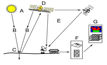
Fig. 1.2. Remote Sensing process.
(Source: gisceu.net/tutorial/chap1/c1p1_i2e.html; August: 10)
C) Interaction with the target- once the energy makes its way to the target through the atmosphere, it interacts with the target depending on the properties of both the target and the radiation.
D) Recording of energy by the sensor- after the energy has been scattered by, or emitted from the target, a sensor is required (remote- not in contact with the target) to collect and record the electromagnetic radiation.
E) Transmission, reception and processing- the energy recorded by the sensor has to be transmitted, often in electronic form, to a receiving and processing station where the data are processed into an image (hardcopy and/or digital).
F) Interpretation and analysis- the processed image is interpreted, visually and/or digitally or electronically, to extract information about the target which was illuminated.
G) Application – the final element of the remote sensing process is application i.e. after extracting the information from the image to solve a particular problem.
Keywords: Remote sensing, GIS, IRS, INSAT, PSLV, ASLV, GSLV.
References
Bhatta, B., 2010, Remote Sensing and GIS, Oxford University Press, New Delhi, pp. 7-8, 64-96.
gisceu.net/tutorial/chap1/c1p1_i2e.html; August: 10
www.isro.org/satellites/earthobservationsatellites.aspx; July 27, 2012
www.isro.org/satellites/geostationary.aspx; July 30
wamis.org/agm/pubs/agm8/Paper-2.pdf
Suggested Reading
Anonymous, 1995, Remote Sensing in India- Present Scenario and Future Thrusts, Journal of the Indian Society of Remote Sensing, 23(1), pp. 1-3.
Chang, K., 2010, Introduction to Geographic Information Systems, pp. xiii-xiv.
Joseph, G., 2005, Fundamentals of Remote Sensing, Universities Press, pp. 13-21.
Lillesand, T. M., 2002, Remote sensing and image interpretation, Fourth Edition, pp. 23, 374-376, 431-434.
spacejournal.ohio.edu/issue9/indian_plan.html; August 16.2012
Last modified: Tuesday, 21 January 2014, 5:06 AM