Site pages
Current course
Participants
General
Module 1: Introduction and Concepts of Remote Sensing
Module 2: Sensors, Platforms and Tracking System
Module 3: Fundamentals of Aerial Photography
Module 4: Digital Image Processing
Module 5: Microwave and Radar System
Module 6: Geographic Information Systems (GIS)
Module 7: Data Models and Structures
Module 8: Map Projections and Datum
Module 9: Operations on Spatial Data
Module 10: Fundamentals of Global Positioning System
Lesson 9 Image Interpretation
9.1Visual Image Interpretation of Photographs and Images
Image interpretation of remote sensing data is to extract qualitative and quantitative information from the photograph or imagery. It involves identification of various objects on the terrain which may be natural or artificial consists of points, lines, or polygons. It depends on the way how different features reflect or emits the incident electromagnetic radiation and their recording by a camera or sensor. In the very beginning, when digital images and computerised classification were not available, the aerial photographs were analyzed only by visual interpretation. Accuracy of the interpretation depends on the training, experience, scale of photograph, geographic location of the study area, associated map, ground observation data etc. After the availability of satellite images, the data were categorized in two processing methods: analogue aerial photographs and digital satellite images. Though satellite images can be visually interpreted and aerial photographs can be processed by computers.
In image or photograph, some objects may be readily identifiable while other may not. It depends on individual perceptions and experience. The detail to which an image or photograph can be analyzed depends on the resolution of the image and scale of the photograph. Satellite images are generally have small scale than aerial photographs and cannot be analyzed stereoscopically.
9.2 Elements of Visual Interpretation
In our daily life we interpret many photos and images, but interpretation of aerial photographs and images are different because of three important aspects: (1) the portrayal of features from an overhead, often unfamiliar, perspective; (2) the frequent use of wavelengths outside of the visible portion of the spectrum; and (3) the depiction of the earth’s surface at unfamiliar scales and. Eight fundamental parameters or elements are used in the interpretation of remote sensing images or photographs. These are tone or color, texture, size, shape, pattern, shadow, site and association. In some cases, a single such element is alone sufficient for successful identification; in others, the use of several elements will be required.
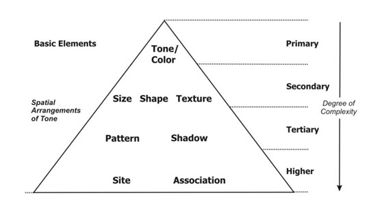
Fig. 9.1. Ordering of image elements in image interpretation.
i) Tone or color: Tone is the relative brightness of grey level on black and white image or color/F.C.C image. Tone is the measure of the intensity of the reflected or emitted radiation of the objects of the terrain. Lower reflected objects appear relatively dark and higher reflected objects appear bright. Figure 9.1a represents a band imaged in NIR region of the electromagnetic spectrum. Rivers does not reflect in NIR region thus appear black and the vegetation reflects much thus appears bright. Our eyes can discriminate only 16-20 grey levels in the black and white photograph, while more than hundreds of color can be distinguished in a color photograph. In multispectral imaging, optimal three bands are used to generate color composite image. False Color Composite (FCC) using NIR, red and green are most preferred combination for visual interpretation. In a standard FCC, NIR band passes through red channel, red band passes through green channel and green band passes through blue channel. Vegetation reflects much in NIR region of the electromagnetic spectrum therefore in standard FCC vegetation appears red (Fig. 9.1b), which is more suitable in vegetation identification.
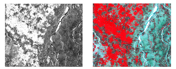
(a) (b)
Fig. 9.2. Satellite image of area in (a) grey scale and in (b) standard FCC.
ii) Texture: Texture refers to the frequency of tonal variation in an image. Texture is produced by an aggregate unit of features which may be too small to be clearly discerned individually on the image. It depends on shape, size, pattern and shadow of terrain features. Texture is always scale or resolution dependent. Same reflected objects may have difference in texture helps in their identification. As an example in a high resolution image grassland and tree crowns have similar tone, but grassland will have smooth texture compared to tree. Smooth texture refers to less tonal variation and rough texture refers to abrupt tonal variation in an imagery or photograph.
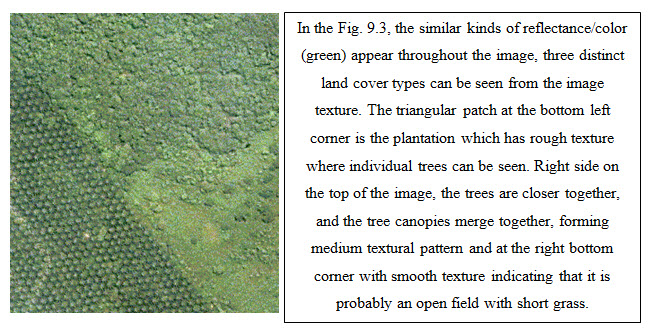
Fig. 9.3. High resolution image showing different textures.
(Source: www.crisp.nus.edu.sg/~research/tutorial/opt_int.htm)
iii) Pattern: Pattern refers to the spatial arrangement of the objects. Objects both natural and manmade have a pattern which aids in their recognition. The repetition of certain general form or relationship in tones and texture creates a pattern, which is characteristic of this element in image interpretation. In the Fig. 9.3 it could be easily understood that at the left bottom corner of the image, it is plantation, where the tress are nearly equally spaced. Whereas at the upper right and bottom right corners show natural vegetation.
iv) Size: Size of objects on images must be considered in the context of the image scale or resolution. It is important to assess the size of a target relative to other objects in the scene, as well as the absolute size, to aid in the interpretation of that target. A quick approximation of target size can make direct interpretation to an appropriate result more quickly. The most measured parameters are length, width, perimeter, area, and occasionally volume. For example, if an interpreter had to distinguish zones of land use, and had identified an area with a number of buildings in it, large buildings such as factories or warehouses would suggest commercial property, whereas small buildings would indicate residential use.
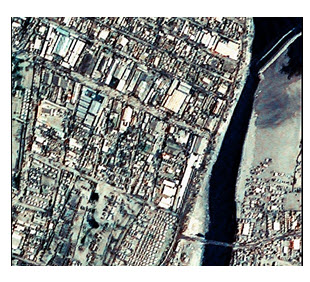
Fig. 9.4. Satellite view of a part of a city.
(Source: parallelspirals.blogspot.in/2010_05_01_archive.html)
v) Shape: Shape refers to the general form, configuration or outline of an individual object. Shape is one of the most important single factors for recognizing object from an image. Generally regular shapes, squares, rectangles, circles are signs of man-made objects, e.g., buildings, roads, and cultivated fields, whereas irregular shapes, with no distinct geometrical pattern are signs of a natural environment, e.g., a river, forest. In a general case of misinterpretation in between roads and train line: roads can have sharp turns, joints perpendicularly, but rails line does not. From the shape of the following image, it can be easily said that the dark-blue colored object is a river.
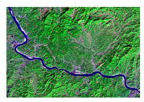
Fig. 9.5. Satellite image of an area
(Source: geology.com/satellite/landsat-images-water.shtml)
vi) Shadow: Shadow is a helpful element in image interpretation. It also creates difficulties for some objects in their identification in the image. Knowing the time of photography, we can estimate the solar elevation/illumination, which helps in height estimation of objects. The outline or shape of a shadow affords an impression of the profile view of objects. But objects within shadow become difficult to interpret. Shadow is also useful for enhancing or identifying topography and landforms, particularly in radar imagery.
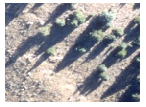
Fig. 9.6. Shadow of objects used for interpretation. (Source: wiki.landscapetoolbox.org/doku.php/ remote_sensing_ methods: image_interpretation)
vii) Association: Association refers to the occurrence of certain features in relation to others objects in the imagery. In urban area a smooth vegetation pattern generally refers to a play ground or grass land not agricultural land (Fig 9.7).
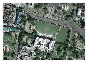
Fig. 9.7. Satellite image of an urban area.
(Source: news.discovery.com/earth/haiti-satellite-earthquake-damage.html)
viii) Site: Site refers to topographic or geographic location. It is also an important element in image interpretation when objects are not clearly identified using the previous the elements. A very high reflectance feature in the Himalayan valley may be snow or cloud, but in Kerala one cannot say it as snow.
9.3 Interpretation Keys
The criterion for identification of an object with interpretation elements is called an interpretation key. The image interpretation depends on the interpretation key which an experienced interpreter has established from prior knowledge and utilizes in the interpretation of the current images. It provides guidance about the correct identification of features or conditions on the images. Generally, eight standardized keys are established to eliminate the difference between different interpreters. The eight interpretation elements are: size, shape, shadow, tone, colour, texture, pattern, and association. For agricultural and tree species identification a number of keys have been successfully employed used on a region-by-region and season-by-season basis, as vegetation can widely vary depending on location and season. Besides these, the time the photograph is taken, film type, and photo-scale should be carefully considered while developing interpretation keys.
The Table 9.1 shows an example of interpretation keys for forestry mapping. The keys are specified with respect to the crown’s shape, rim shape of the crown, tone, shadow, projected, tree shape, pattern, texture, and other factors.
Table 9.1 Interpretation keys for forestry mapping
|
Species |
Crown shape |
Edge of Crown |
Tone |
Pattern |
Texture |
|
Cedar |
Conical with sharp spear |
Circular and sharp |
Dark |
Spotted grain |
Hard and coarse |
|
Cypress |
Conical with round crown |
Circular but not sharp |
Dark but lighter than cedar |
Spotted |
Hard and fine |
|
Pine |
Cylindrical with shapeless crown |
Circular but unclear |
Light and unclear |
Irregularly spotted |
Soft but coarse |
|
Larch |
Conical with unclear crown |
Circular with unclear edge |
Lighter than cypress |
Spotted |
Soft and fine |
|
Fir/spruce |
Conical with wide crown |
Circular with zig-zag edge |
Dark and clear |
Irregular |
Coarse |
|
Deciduous |
Irregular shapes |
Unclear |
Lighter |
Irregular |
Coarse |
(Source: Bhatta, 2008)
9.4 Generation of Thematic Maps
An image interpretation map is usually produced by transferring the interpreted information to a base map which has been prepared in advance. The requirements of the base map should be as follows:
Proper map scale to enable appropriate presentation of interpreted information.
Geographic coordinate system to establish the geographic reference.
Basic map information to be printed in light tones as background which results in enhancement of interpreted information
Normally, a topographic map (Toposheet), plan map, or orthophotomap is used as a base map.
A topographic map with a scale of 1:50,000 to 1:250,000 is usually the preferable base map for higher resolution satellite image interpretation. For oceanographic purposes or marine science, a scale of 1:50,000 to 1:500,000 may be used as the base map.
Orthophotomap are more easily used by cartographers for the transfer of interpreted information. For example, in case of forest classification.
The methods of transfer of information to a base map are as follows:
The interpreted image is traced on to a base map by overlaying on a light table.
The interpreted image is projected via a lens and a mirror onto a base map optical projection. The optical zoom transfer scope or mirror projector is very useful for image interpretation.
Using grid system grid lines are drawn on both image and base map. Then the interpreted information in a grid on the image is transferred to the corresponding grid on the map.
Photogrammetric plotting aerial photographs are interpreted into a thematic map using a photogrammetric plotter.
Keywords: Visual image interpretation, Elements, FCC, Interpretation keys, Thematic maps.
References
Bhatta, B., 2008, Remote sensing and GIS, Oxford University Press, New Delhi, pp. 278-289.
geology.com/satellite/landsat-images-water.shtml
news.discovery.com/earth/haiti-satellite-earthquake-damage.html
parallelspirals.blogspot.in/2010_05_01_archive.html
wiki.landscapetoolbox.org/doku.php/ remote_sensing_ methods: image_interpretation
www.crisp.nus.edu.sg/~research/tutorial/opt_int.htm
Suggested Reading
Cambell, J. B., Wynne, R H., 1996, Introduction to remote sensing.Fifth Edition, Guilford Press, pp. 131.
Joseph, G., 2005, Fundamentals of remote sensing, Second Edition, Universities Press (India) Pvt. Ltd., pp. 320-321.
Lillesand, T. M., Kiefer, R. W., 2002, Remote sensing and image interpretation. Fourth Edition, pp. 192-193.
nile.riverawarenesskit.org/English/NRAK/EO/html/rsbch14.html
www.geos.ed.ac.uk/research/eeo/belize/Image_interpretation.pdf
www.jars1974.net/pdf/08_Chapter07.pdf
www.scribd.com/doc/20610288/Visual-Image-Interpretation-Text
Last modified: Tuesday, 21 January 2014, 6:30 AM