Site pages
Current course
Participants
General
Module 1. Perspective on Soil and Water Conservation
Module 2. Pre-requisites for Soil and Water Conse...
Module 3. Design of Permanent Gully Control Struct...
Module 4. Water Storage Structures
Module 5. Trenching and Diversion Structures
Module 6. Cost Estimation
5 April - 11 April
12 April - 18 April
19 April - 25 April
26 April - 2 May
Lesson 4. Physiographic Characteristics of Watershed
4.1 The Watershed
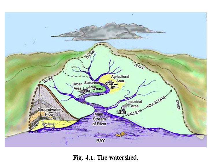
A watershed represents land area usually contains a well-connected stream network and well defined outlet or discharge point, where the representative area drains when rainfall occurs. In other words, area of the land over which runoff generates and then drains into stream at a given location is called watershed or catchment area. Watershed is also known as drainage basin, catchment area etc.
(Source: http://fergusonfoundation.org/btw-students/what-is-a-watershed/ accessed on 2 October 2013)
4.2 Physiographic Characteristics of Watershed
Physiographic characteristics of any watershed are the description of watershed in terms of area, slope, shape, drainage density, aspect, relief, land use and soil characteristics etc. Physical properties of watersheds significantly affect the characteristics of runoff and as such are of great interest in hydrologic analyses. These watershed characteristics are described below in details.
4.2.1 Area of the Watershed
The area of watershed is also known as the drainage area and it is the most important watershed characteristic for hydrologic analysis. The runoff from watershed is generated after the interaction of precipitation with the watershed area. Watershed area is important parameters in hydrological model to estimate the volume of runoff. The area of watershed is delineated either manually using toposheets or through digital elevation model derived using geographic information system (GIS). Once the watershed has been delineated, its area can be determined using planimeter or can be approximated using GIS.
(Source: http://cas.umkc.edu/geosciences/env-sci/module9/h20shed.GIF accessed on 2 October 2013)
The size of a watershed may vary from a few hectares to thousands of square kilometer. Table 4.1 provides a system of classifying watersheds at different levels of aggregation.
Table 4.1: System of Classification of Watersheds in India
|
Category |
Number |
Size Ranges ('oooha.) |
|
Regions |
6 |
25,000-100,000 |
|
Basins |
35 |
3,000-25,000 |
|
Catchments |
112 |
1,000-3,000 |
|
Sub-Catchments |
500 |
200-1,000 |
|
Watersheds |
3,237 |
50-200 |
|
Sub-watersheds |
12,000 |
10-50 |
|
Milli-watersheds |
72,000 |
1-10 |
|
Micro-watersheds |
400,000 |
0.5-1 |
(Source: Bali, 1979)
4.2.2 Length of Watershed
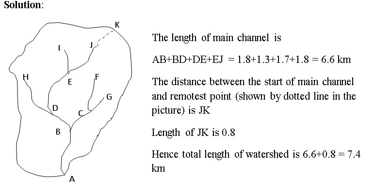
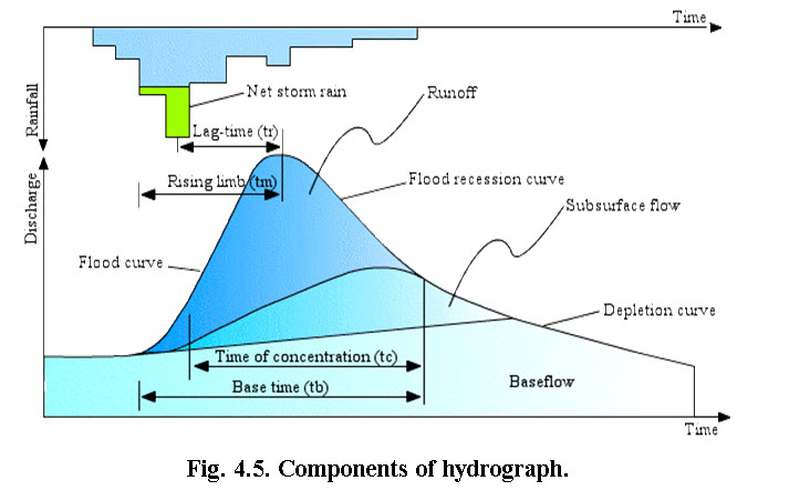
Length of watershed is defined as the longest distance between outlet and any point on the perimeter. This length is usually measured to compute the time dependent parameters of watershed such as time of concentration (time taken to reach the runoff generated from remotest point of watershed to outlet).Time dependent parameters of watershed are useful in determining time for peak flow required to establish the hydrograph of the watershed. The watershed length is therefore measured along the principal flow path from the watershed perimeter to the outlet. Since the channel does not start from the watershed boundary, it is determined by extending the main channel to the boundary and then measuring the length of the channel.
Example 4.1: Main channel passes through points A, B, D, E and J. The length of AB is 1.8 km, BD is 1.3 km, DE is 1.7 km and EJ is 1.8 km. The remotest point of the watershed is K which is 0.8 km far from the start of main channel, i.e., point J. What will be the watershed length?
4.2.3 Slope of Watershed
Watershed slope reflects the rate of change of elevation with respect to distance along the principal flow path. It is usually calculated as the elevation difference between the highest and lowest elevation of the point of the watershed divided by watershed length. Watershed slope affects time of concentration, as well as time to peak.
Example 4.2: In continuation of example 1: K, A and J is having elevations of578m, 316 m, 532 m respectively. Calculate the watershed slope, channel slope and overland slope?
Watershed slope = elevation difference between point K and A divided by watershed length i.e. (578-316)/7.4 = 262/7.4 = 35.4 m per km = 3.54%
Channel slope = elevation difference between point J and A divided by channel length i.e. (532-316)/6.6 = 216/6.6 = 32.73 m per km = 3.27%
Overland slope = elevation difference between point K and J divided by length of overland flow i.e. (578-532)/0.8 = 57.5 m per km = 5.75%
In this case overland slope is higher than channel slope, hence on field soil conservation activities such as trenching and bunding etc. should be prioritize over drop structures etc.
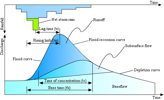
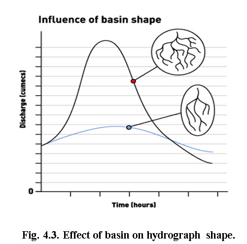
4.2.4 Shape of Watershed
Watershed shape basically determines the shape of the resulting hydrograph. Watersheds have an infinite variety of shapes, and the shape supposedly reflects the way that runoff will accumulated at the outlet. A circular watershed would result in runoff from various parts of the watershed reaching the outlet at the same time. An elliptical watershed having the outlet at one end of the major axis and having the same area as the circular watershed would cause the runoff to be spread out over time, thus producing a smaller flood peak than that of the circular watershed. Fig. 4.3 showing the basin effects on hydrograph shape.
(Source:http://www.bbc.co.uk/scotland/education/int/geog/rivers/images/hydrographs/hydro2.gif accessed on 3 October 2013)
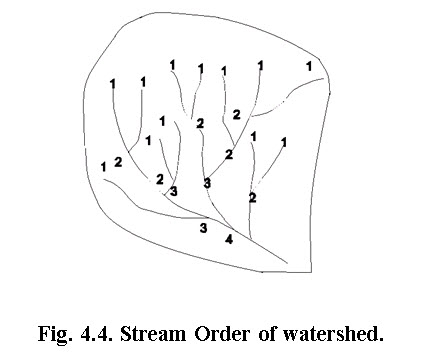
4.2.5 Stream Order
The order of stream is hierarchical arrangement of different streams in the watershed. The first order streams are the originating streams and mostly in the forms of G1 or G2 type gullies. On confluence of two first order streams, downstream is called second order stream. If second order stream is confluences with first order stream, the stream still is second order. However, if two second order streams confluences, then 3 order stream comes in existence. The general rule is that when two same order stream confluences, next order stream comes into existence. Most of the watersheds are having 3rd order streams. However, the big catchment, the stream order may be of 5th and higher.
A number of watershed parameters have been developed to reflect basin shape. Following are a few typical parameters:
Table 4.1. Formula to determine different shape factor of watersheds and its effect on hydrograph
|
SL. No |
Characteristics |
Formula |
Effect on hydrograph shape (refer figure below) |
|
1 |
Stream order |
Hierarchical |
Higher stream order increases time of concentration, time to peak and base time |
|
2 |
Stream length |
Length of the stream |
Higher the length, higher the time of concentration, time to peak and base time |
|
3 |
Bifurcation ratio |
Rb = Bifurcation ratio, nu = number of stream segment of order u nu+1 = number of stream segment of order u+1 |
Higher the length, higher the time of concentration, time to peak and base time |
|
4 |
Relief ratio |
Rh = relief ratio; H = total relief of watershed in kilometer and Lb = watershed length, km |
Higher relief reduces time to peak and increases peak discharge |
|
5 |
Drainage density |
D = drainage density; Lu = total stream length of all orders, km and A = watershed area, km2 |
Higher drainage density increase time to peak and peak discharge |
|
6 |
Form factor |
Rf = Form factor, A = watershed area, km2 Lb= watershed length, km |
Higher form factor increases peak discharge and reduces time of concentration and base time |
|
7 |
Circularity ratio |
Rc = circularity ration, A = watershed area,km2 and P watershed perimeter, km |
As circulatory ration approaches to unity, time of concentration and peak discharge increases. |
|
8 |
Elongation ratio |
Re = Elongation ratio, A = area of watershed, km2 Lb = watershed length, km |
Higher elongation ration increases concentration time and time to peak. |
|
9 |
Length of overland flow |
(Horton, 1945) Lg = length of overland flow, km D = Drainage density, km-1
|
More length of overland flow increases time of concentration, time to peak and reduces peak discharge. |
(Source: Chow, 1964)
 (Source:http://echo2.epfl.ch/VICAIRE/mod_1a/chapt_8/pictures/Figure87.gif, accessed on 3 October 2013)
4.2.6 Watershed Maps
There are several watershed maps describing different characteristics of watershed. These are also known as thematic maps. The map include elevation map (contour map), land use/land cover map, slope map, soil map, flow direction map, watershed delineation map etc. These thematic maps are overlaid in order to determine the specific characteristics of watershed. The GIS is often used in the overlaying process and map calculations.
4.2.6.1 Delineating Watershed Boundary from Toposheet
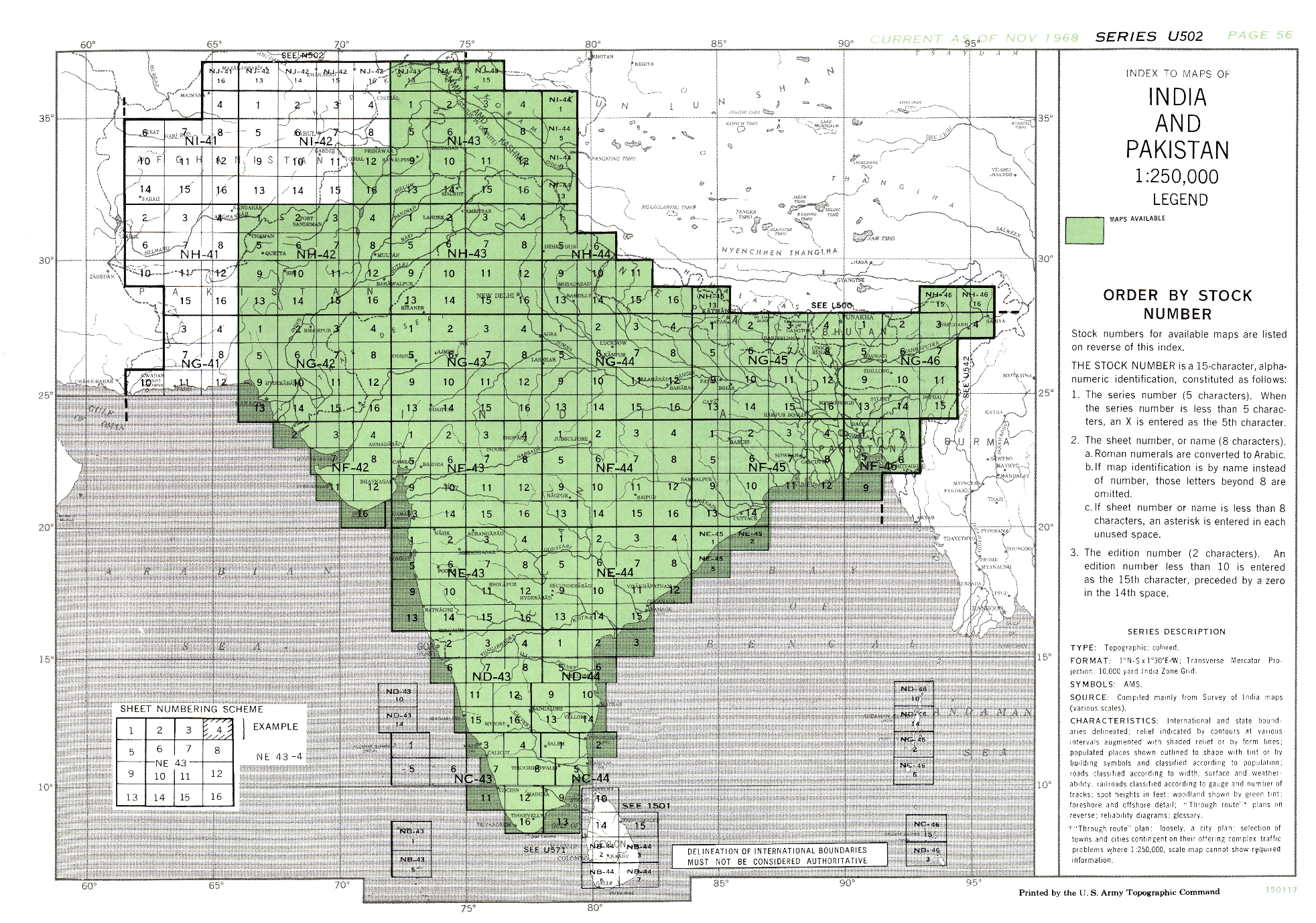
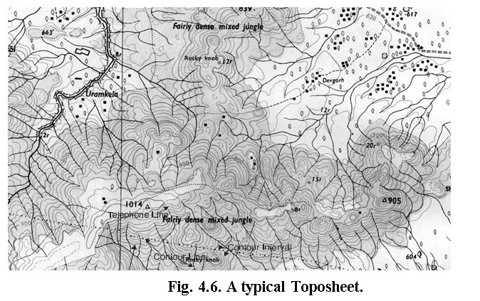
Topographical maps provide information about the lay of the land. The special feature of topographical maps (or toposheets) is that along with direction, scale and legend, they also provide information about the relief of the land using contour lines(contour lines are imaginary lines joining points on the same elevation). It also contains the information of drainage network, water harvesting structures, land use, soil type villages and urban settlements, roads. A typical toposheet is shown in Fig. 4.6.Toposheets are made on the basis of latitudes and longitudes. Every part of India has been mapped by the Survey of India, using latitudes and longitudes to classify the country into a grid. Toposheets are available mainly on 3 scales: 1:1,000,000, 1:2, 50,000 and 1:50,000. For some special areas toposheets on 1:25,000 are also available.
(Source:http://www.lib.utexas.edu/maps/ams/india/ams150117indiapakistan.jpg, accessed on 3 October 2013)
4.2.6.1.1 Steps for Watershed Delineation
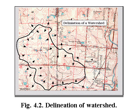
Step 1. Identify the point with respect to which the watershed is to be marked(the exit point or outlet). In Fig. 4.7, this is the point marked "A".
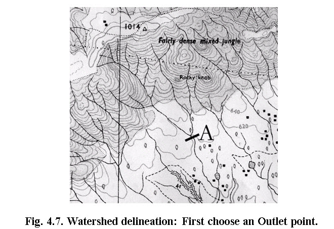
(Source: BACPE, 2007)
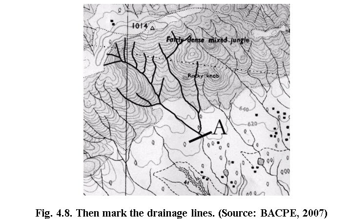
Step 2. Mark out drainage lines of various orders, which drain into this common point (Fig. 4.8).The way to do this is to begin from the exit point (A) and move along the drainage line to its origin. Mark out nearby drainage lines which do not drain to this common point. Different colours can be used to distinguish drainage lines belonging to our watershed from drainage lines outside our area.
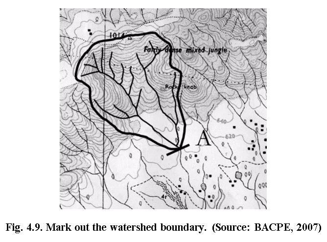
Step 3. From the exit point, draw a line around the drainage system, enclosing all drainage lines which drain to point A and leaving out other drainage lines which do not drain to point A (see Fig. 4.9). This boundary line will terminate at the exit point. This line demarcating the watershed boundary is called a ridge line. A ridge line is an imaginary line joining all points of higher elevation in a selected watershed and separating the watershed from other watersheds
Precautions
- Remember to be very careful when outlining drainage lines, particularly when including drainage lines which fall in the watershed and leaving out those that do not.
- Remember that a toposheet shows several other lines (such as roads, telephone lines), which on a photocopy will look similar to a contour line. So exercise care.
- Ensure that the watershed boundary (the ridge line) never crosses any drainage line inside the watershed. If this has happened, be sure that it is a mistake and correct it.
4.2.6.2 Automatic Delineation of Watershed
The watersheds can also be delineated automatically using modern computing tools such as GIS. GIS needs digital elevation map (DEM) for automatic delineation of watershed. In this case the contour features from toposheets are scanned and accordingly digitized using either screen digitizer or table digitizer. Respective elevations are assigned to the digitized contour. After elevations are assigned, the outlet is defined using latitude and longitude. The GIS calculates the flow direction map, slope map, flow accumulation map and computes drainage network and using these maps along with drainage network, GIS finally delineate watershed. However, watershed delineated using GIS should be cross checked with the toposheet. Nowadays DEM are available at various websites as a free resource (eg: http://www.bhuvan.nrsc.gov.in/bhuvan_links.php, etc.), such as SRTM (Shuttle Radar Topographic Mapping) or ASTER (Advanced Space born Thermal Emission and Reflection) and can be used to delineate the watershed. The DEM from SRTM or ASTER source usually has 1 meter elevation interval and 30 and 90 m resolution in grid form. The 30 m resolution suggest singular elevation value for 0.09 ha (30mX30m) and similarly 90 meter resolution suggest singular elevation value for 0.81 ha (90mX90m). Though the automatic delineation is free from human interventions and errors and produces same result every time. However, these are limitations as well. Accuracy is largely dependent on resolution (Higher the resolution, greater the accuracy). Higher resolution data requires higher computing and data transfer infrastructure along with highly skilled personnel. This may significantly increase the cost of delineation.
References
Baba Amte Center for People’s Empowerment. (2007). Watershed manual for National Rural Employment Guarantee Act. Min. of Rural Development. Govt. of India.
Bali, Y.P. (1979). Watershed Management—Concept and Strategy, in P.N.Bhatt (ed.), Watershed Management, Lectures Delivered at Short Course, Dehradun: Central Soil and Water Conservation Research and Training Institute.
Chow, V.T. (1964). Applied Hydrology. McGraw-Hill, New York.
Das, G. (2000). Hydrology and Soil Conservation Engineering. Prentice Hall of India, New Delhi, India.
Subramanya, K. (2010). Engineering Hydrology. 3rd ed. Tata McGraw-Hill, New Delhi, India.
Internet References
http://www.thebigger.com/biology/resources/what-is-the-conservation-of-soil/ : accessed on 08.11.2012
http://www.mbgnet.net/fresh/rivers/shed.htm:accessed on 08.11.2012
http://fergusonfoundation.org/btw-students/what-is-a-watershed/ : accessed on 03.10.2013
http://cas.umkc.edu/geosciences/env-sci/module9/h20shed.GIF : accessed on 03.10.2013
http://www.bbc.co.uk/scotland/education/int/geog/rivers/images/hydrographs/hydro2.gif : accessed on 03.10.2013
http://echo2.epfl.ch/VICAIRE/mod_1a/chapt_8/pictures/Figure87.gif : accessed on 03.10.2013
Suggested Readings
Chow, V.T. (1964). Applied Hydrology. McGraw-Hill, New York.
Das, G. (2000). Hydrology and Soil Conservation Engineering. Prentice Hall of India, New Delhi, India.
Subramanya, K. (2010). Engineering Hydrology. 3rd ed. Tata McGraw-Hill, New Delhi, India.
Last modified: Tuesday, 21 January 2014, 6:13 AM