Site pages
Current course
Participants
General
MODULE 1.
MODULE 2.
MODULE 3.
MODULE 4.
MODULE 5.
MODULE 6.
MODULE 7.
MODULE 8.
MODULE 9.
26 April - 2 May
Lesson 7. Plane table surveying
Plane Table Surveying
- Plane table surveying is a graphical method of surveying in which the field works and the plotting is done simultaneously. It is particularly adopting in small areas mapping. Plane table surveying is used for locating the field computation of area of field.
Merits
-
It is most suitable for preparing small scale map or surveying small area.
-
It is most rapid method.
-
Field book is not necessary.
-
No great skill is required for satisfactory map.
-
It is particularly suitable for magnetic area where prismatic compass is not reliable.
-
Contour and irregular object may be represented accurately.
-
It is less costly.
Demerits
-
Plane Table Essentially a tropical instruments.
-
It is not suitable to work in wet climate.
-
There are several accessories to be carried out and therefore they are likely to be lost.
-
It is not suitable for accurate work.
Plane Table essentially consists of a Drawing board mounted on tripod stand and Alidade.
1. Drawing board mounted on tripod
A sheet of drawing paper, called plane table sheet is fastened to the board. Board is made up of well seasoned wood such as teak of size 40x30 to 75x60cm. it had plane and smooth top. It is mounted on a tripod in manner that it can be leveled. Leveling up of the table is done by shifting the legs of tripod. Some tripod provided with leveling screw or by ball and socket head for accurate leveling.
2. Alidade:
Alidade consists of two vertical sight vane fitted at end the end of straightedge. The straight edge ruler usually made of brass or teak wood graduated beloved edge. One of the sight veins is provided with narrow slit and the other with a central vertical wire or hair. Beveled working edge alidade is called fiducial edge.
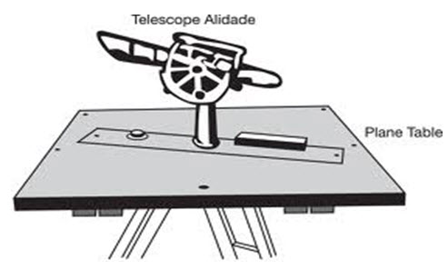
Fig. 6.1 Plane table with Alidade
Accessories used in Plane Table surveying are
1. Trough compass
2. U – frame or plumbing fork
3. Water proof cover.
4. Spirit level or level tube
5. Drawing sheet
6. Pencil or eraser
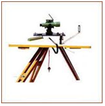
Fig. 6.2 Accessories in Plane Table surveying
Trough compass: The compass is used to mark the direction of the meridian on the paper.
U- frame or Plumbing fork: U frame with a plumb bob used for centering the table.
Water Proof Cover: Water Proof cover protects the sheet from rain.
Spirit level or level tube: A level tube is used to level the plane table.
Drawing sheet: The drawing sheet is fixed on the top of the drawing board.
Pencil and eraser: A pencil is used for constructing lines and eraser is used for erasing lines after completion of the plan.
Operations involved in Plane Table Surveying
SETTING UP THE PLANE TABLE
The setting up the plane table includes the following three operations.
1. Centering the plane table
2. Leveling the plane table
3. Orientation of plane table
CENTERING THE PLANE TABLE:
The table should be set up at a convenient height for working say about 1m. The legs of tripod should be spread well apart and firmly fixed in to the ground. The table should be approximately leveled by tripod legs and judging by the eye. Then the operation of centering is carried out by means of U-frame and plumb bob. The plane table is exactly placed over the ground station by U-frame and plumb bob.
LEVELING THE PLANE TABLE:
The process of leveling is carried out with the help of level tube. The bubble of level tube is brought to center in two directions, which are right angles to each other. This is achieved by moving legs.
ORIENTING THE TABLE:
The process of keeping the plane table always parallel to the position, which is occupied at the first station, is known as orientation. When the plane table is oriented, the lines on the board are parallel to the lines on the ground.
Last modified: Wednesday, 30 October 2013, 11:05 AM