Site pages
Current course
Participants
General
Module 1: Formation of Gully and Ravine
Module 2: Hydrological Parameters Related to Soil ...
Module 3: Soil Erosion Processes and Estimation
Module 4: Vegetative and Structural Measures for E...
Keywords
Lesson 1 Introduction
1.1 Soil Erosion and Its Causes
Land degradation is one of the most serious global challenges to sustainability of agriculture at present. It is temporary or permanent reduction in the productive capacity of land as a result of human action.
Watershed, a geographical area that contributes runoff to a common point, has been accepted as a basic unit for planning and implementation of the protective, curative and ameliorative programmes addressing land degradation. A thorough understanding of the hydrological behavior of a watershed is important for developing an effective watershed management plan and also for transferring the results of one watershed to another with similar characteristics (Tripathi and Panda, 1999).
Soil erosion is one of the most serious problems in the world. The problem of soil erosion is prevalent over about 53 % of the total land area of India. Soil erosion has caused major environmental disasters worldwide. Many urban and rural communities have been severely affected, while the sustainability of the total landscape has been threatened. Human and animal population, physical infrastructure, agricultural lands and socio economic system of the land/areas are adversely exposed to multifaceted hazards. Some of the adverse impacts of soil erosion are: (i) it removes fertile top soil rendering the eroded area poorly productive; (ii) it causes sedimentation of the downstream river reaches that in turn changes flow section, slows down the flow rate and increases pollution hazard; (iii) gradual deposition of silt at the downstream river reaches raises the river bed elevation and causes flood hazard; (iv) sedimentation of the reservoirs built across rivers reduces their live storage capacity, which adversely affects drinking water supply projects, irrigation projects and hydro-electric projects depending on the reservoir water; (v) silt deposit may give rise to river braiding and river meandering, which adversely impacts the river bank inhabitants, and (vi) soil erosion makes above-ground structures unsafe.
Soil erosion is a physical process with considerable variation globally in its severity and frequency. It is also strongly influenced by social, economic, political and institutional factors.
Soil erosion is a three-stage process:
(1) Detachment,
(2) Transport, and
(3) Deposition of soil.
There are four principal sources of energy: physical, such as wind and water direct rainfall as well as flowing water); gravity, chemical reactions responsible for weathering of parent rocks to form soils and anthropogenic, such as faulty tillage operations or improper cropping practices. Soil erosion begins with detachment, which is caused by breaking down of aggregates by rain drop impact, sheer or drag force of water and wind. Detached particles are transported by flowing water (over-land flow and inter-flow) and wind, and deposited when the velocity of water or wind decreases due to the effect of slope or ground cover.
Three processes that accelerate the natural rate of soil erosion are:
(1) Dispersion,
(2) Compaction and
(3) Crusting,
These processes decrease structural stability, reduce soil strength, increase erodibility and intensify susceptibility to transport by overland flow, interflow, wind or gravity. These processes are accentuated by soil disturbance (i.e. by tillage, vehicular traffic), lack of ground cover (i.e. bare fallow, residue removal or burning) and harsh climate (i.e. high rainfall intensity and
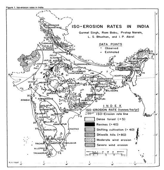
Fig.1.1. Soil erosion rates in India. (Source: http://www.ciesin.org/docs/002-413/002-413.html)
Causes of Erosion
Erosion occurs when farming practices are not compatible with the soil and land slope limitations such as non-cohesive soils and steeper land slopes that make the soil more prone to be washed away or blown away. These practices are:
Overstocking and overgrazing
Inappropriate farming techniques such as deep ploughing of land 2 or 3 times a year to produce annual crops
Lack of crop rotation
Planting crops along the slope instead of along the contour.
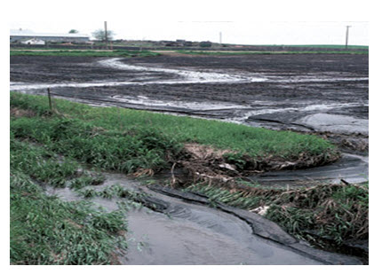
Fig. 1.1. Soil erosion. (Source: http://www.networlddirectory.com/images/blogs/10-2007/soil-erosion-2290.jpg)
1.2 Definition of Gully and Ravine
1.2.1 Gully Erosion
The gullies are linear incision channels of at least 0.3m width and 0.3m depth. Gully erosion creates either V- or U-shaped channels. Gullies are primarily formed by concentrated runoff converging towards lower points of the watershed. Thus, erosion occurring in these channels is known as concentrated flow erosion. Undulating fields cause runoff to concentrate in natural swales as runoff moves down slope in narrow paths in the form of channelized flow. A swale is a low tract of land, which is moist or marshy. It may be naturally occurring landscape or human-created. Continued gully erosion removes entire soil profiles in localized segments of the field. As gullies grow, more sediment is transported.
Gully erosion is the advance stage of channel or rill erosion in which the size of rill is enlarged which can not be smoothened by ordinary tillage implements. Process of gully formation follows sheet and rill erosion. Gully erosion produces channels larger than rills. These channels carry water during and immediately after rains.
Gullies may also be developed from rills which are unchecked. Development of gullies also takes place by ruts or tracks formed by the movement of machineries, down the slope.
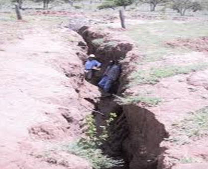
Fig. 1.2. Gully erosion. (Source: http://www.permacultureplants.net/NgareNdare/NgareNdareIntro.htm)
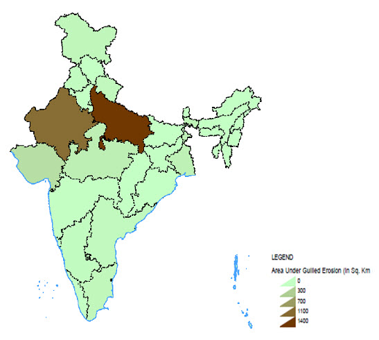
Fig. 1.3. Total gullied erosion in India. (Source: Wasteland atlas of India) (Source: http://www.soeatlas.org/PDF_Map%20Gallery/Gullied%20Erosion.pdf)
The rate and extent of gully development are closely related to the amount and velocity of runoff water, since large amount of flowing water tends to detach and transport the soil in relatively larger amount. The amount of runoff water available is dependent upon the size and runoff producing charecterstics of the drainage area (watershed) involved. The amount of sediment from gully erosion is usually less than from upland areas. In tropical areas, gully growth following deforestation and cultivation has led to severe problems from soil loss, and damage to building, roads and airport. The rate of gully erosion depends primarily on the runoff-producing charecteristics of the watershed, the drainage area, soil charecterstics, the alignment, size and shape of the gully, and the slope in the chanel.
1.2.2 Ravine Erosion
A ravine is a very narrow, steep sided fissure in the Earth's surface. Ravines are smaller than valleys, but larger than gullies, although a ravine has the potential to develop into a valley, over the course of thousands of years. A ravine is generally a fluvial slope landform of relatively steep (cross-sectional) sides, of the order of twenty to seventy percent in gradient. Ravines may or may not have active streams flowing along the down slope channel which originally formed them. Moreover, often they are characterized by intermittent streams, since their geographic scale and their catchment areas may not be sufficiently large to support a perennial stream.
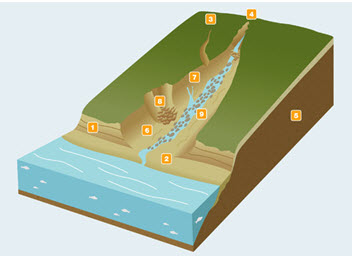
Fig. 1.3. Ravine erosion. (Source: http://wiki.fis-ski.com/images/Ravines.jpg)
Typically, a ravine is formed through the process of erosion, and it starts out as the site of a small stream or river. Over time, the water wears a deep groove into the Earth, which attracts water as it drains from other locations, speeding up the erosion process. Eventually, a ravine may lose its stream, or have only intermittent water flow, because of lack of water supply from the catchment. Sometimes, however, a ravine will have a year-round watercourse.
Generation of large quantities of waste water in the urban areas and a generally poor urban drainage promote the formation of ravines. It is common for water to collect in a large mass in urban areas, creating a torrent, because it cannot percolate naturally through the soil to drain away. Because the water eventually finds a path to flow under gravity, it can end up creating a cutting in periods of flooding and heavy rain, and this will develop into a ravine.
Ravines have historically been used for garbage disposal, because of their depth and steep sides. Although this practice is largely discouraged today, ravines still tend to collect garbage, which is carried by the water which periodically pours through them as well as being tossed in by careless litterers. In urban areas, service organizations may designate a day each year to clean up local ravines, canyons, and waterways so that the garbage is not allowed to accumulate for too long.
Depending on the location of a ravine, it may also serve as habitat for local wildlife, especially in regions where wildlife is under pressure due to human habitation. Humans tend to avoid ravines, since they are difficult to navigate, and this allows a variety of creatures to move in and live undisturbed at the site. As a result, ravines are sometimes developed into habitations for birds and other forms of wildlife (http://www.wisegeek.com/what-is-a-ravine.htm).
Stages of Gully Erosion
The four recognised stages of gully development are given as under:
Stage1: In this stage channel erosion and deepening of the gully bed takes place. It is initiation stage and this stage normally proceeds slowly.
Stage 2: It is the development stage, in which due to runoff from up stream portion of the gully head, the size of gully width and depth is enlarged.
Stage 3: This is the healing stage, in which vegetation starts to grow in the channel. During this stage, there is no appericiable erosion in any form, from the gully section.
Stage 4: This is the last stage of gully development, in which gully is fully stablized. No further development of gully occurs, unless healing process is disturbed. The channel has a stable gradient and gully walls gain a stable slope and vegetation begins to grow in abundance to cover the soil surface.
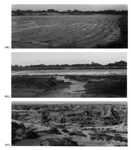
Fig. 1.4. (a) Initial stage of land degradation, i.e. wash off erosion in cultivated field, depicting concentration of flow inducing incarnation of rill. (b) Runoff causing gully head cut at the point of vertical fall, beginning of severe land degradation. (c) Severely degraded ravine waste land in the Yamuna Chambal ravinous belt. (Source: http://www.sciencedirect.com/science/article/pii/S0378377402001580)
Classification of Gully: Gullies are classified as follows:
1) Based on Shape of the Gully: Gullies are classified into the following two shapes:
a) U-Shaped
Generally found in the alluvial plains, where surface and sub-surface soils are eaisly erodible. The specific features of these gullies are:
U-shaped cross-section
Longitudinal slope of gully bottom is usually parallel to the slope of the land, through which the gully passes.
The runoff contributing catchment area being large, the discharge passing through these gullies is large.
The velocity of flow is relatively lower than that of the V-shaped gullies.
U-shaped gullies continue to grow headward.
The lateral spacing of these gullies is large.
Active erosion in these gullies, is from side banks and the gully head as a result of undercutting at these at the base of vertical cut.
These gullies do not grow deeper, but becomes wider and longer, progressing headward.
b) V-shaped
The V-shaped gullies are often developed where the sub-soils are tough enough to resist the rapid cutting of soil by the runoff. As resistence to erosion increases with depth, the width of cut decreases accordingly and results in development of V-shaped gully.
V-shaped gullies have the following major features:
V-shaped cross-section.
Generally appear on sloping field.
Longitudinal gradient of channel is greater than the land slope.
Catchment area contributing the runoff is small.
The lateral spacing between these gullies is small.
Tha amount of discharge, passing through these gullies is small but has higher velocity.
The V-gullies make the contour cutivation difficult.
V-shaped gullies often devlop from rill erosion, when water is concentrated from several rills into one.
The shape of the gully depends upon the soil characterstics, climatic conditions, age of the gully and the types of erosion.
2) Based on State of the Gully
Gullies can be classified into the following types:
i. Active Gullies: active gullies are those, whose dimensions are enlarged with time. The size enlargement is based on the soil charecterstics, land use and volume of runoff passing through the gully. The gullies found in plain area is active.
ii. Inactive Gullies: dimension do not appreciably change with time. These gullies found in rocky areas, are inactive because rocks are resistant to erosion by the runoff flow.
3) Based on Dimensions of Gully
Gullies are clasified based on their size as:
i. Small Gullies, can be easily crossed by farm implements and can also be smoothened by ploughing and other land development operations and by stablizing them through vegetation.
ii. Medium Gullies, can not be easily crossed by farm implements. They can be controlled by terrecing or ploughing operations. In medium gullies, the sides are stablized by promoting vegetative growth on them.
iii. Large Gullies: these gullies can not be reclaimed. For controlling these tree plantation is done as an effective measure.
1.3 Causes of Gully Erosion
There are two types of causes to activate the gully formation:
a) Natural Causes
Rainfall
Runoff
Flood
Soil Properties
Vegetative Cover
b) Anthropogenic Causes
Creating land surface without vegetation.
Road construction
Adoption of faulty tillage practices.
Overgrazing and other form of biotic pressure on the vegetative cover, existing on the land surface.
Absence of vegetative cover.
Improper construction of water channels, roads, rail lines, cattle trails etc.
Effect of Gully Erosion
Loss of soil productivity
Adverse effect on other water resource facilities
Loss of reservoir storage capacity
Flood impacts
Recreational impacts
Deterioration of water quality
1.4 Introduction to Control Measures
Gullies are formed by excessive surface runoff, flowing with high velocity and force that are sufficient to detach soil particles and carry away them along the runoff flow path. Gully and channel erosion frequently occur because of increased water flowing from denuded areas. The runoff can start from bare land, faulty drainage, farm roads, neglected rills and furrow in farm field or from clogged drainage canals.
For controlling gully erosion, the following considerations are very important:
Improving the catchment area of the gully
Stabilization of gully head
Safely conduct water through the gully, provided that it is not a part of natural drainage system of the area
Adoption of gully control measures to stabilize them
Gully Control Measures
Control by Vegetation: vegetaion provides soil cover and protect the gully against scouring. It also reduces the flow velocity by increasing the hydraulic ressistance of the channel section, thereby the scouring and ability of runoff is reduced to a great extent.
Control by Structures: structures are used to control the flow velocity. Structures are of two types:
A) Temporary Structures: temporary structures are constructed to serve the following purposes:
To collect sufficient amount of soil on their upstream portion to build up a huge growth of vegetative cover.
To check the gully erosion until sufficient vegetation has been established at the critical points of gully.
Temporary Structures are:
1) Brushwood dam:
Single row brushwood dam
Double row brushwood dam
2) Loose rock fill dam
3) Log check dam
4) Netting dam
5) Staggered trenches or bunds
6) Terraces (there are stable permanent terraces also used for crop cultivation)
7) Grassed water ways
B) Permanent structures: These structures are made of permanent materials such as: masonary, reinforced concrete or earth etc.
For the purpose of gully control, the following types of permanent structures are used:
1) Spillway:
a) Drop inlet spillway
b) Straight drop spillway
c) Chute spillway
2) Rubble masoonary dam
3) Concrete dam
4) Gabions
5) Silt trap dam
1.5 Organizations in India dealing with Soil Conservation Related Issues
1) Central Arid Zone Research Institute, Jodhpur, Rajsthan
2) Central Institute Brackishwater Aquaculture, Chennai, Tamilnadu
3) Central Institute of Arid Horticulture, Bikaner, Rajsthan
4) Central Research Institute of Dryland Agriculture, Hyderabad, Andhra Pradesh
5) Central Soil and Water Conservation Research and Training Institute, Dehradun, Uttrakhand
6) Central Soil Salinity Research Institute, Karnal, Haryana
7) ICAR Research Complex for Eastern Region including Centre of Makhana, Patna, Bihar
8) Indian Institute of Soil Sciences, Bhopal, Madhya Pradesh
9) National Bureau of Soil Survey and Land Use Planning, Nagpur, Maharastra
10) Damodar Valley Corporation, Hazaribagh, Jharkhand
11) Central Water Commission, Govt. of India
Last modified: Monday, 30 September 2013, 3:51 AM