Site pages
Current course
Participants
General
Module 1: Formation of Gully and Ravine
Module 2: Hydrological Parameters Related to Soil ...
Module 3: Soil Erosion Processes and Estimation
Module 4: Vegetative and Structural Measures for E...
Keywords
Lesson 2 Extent of Gully and Ravine Erosion Problem
2.1 Extent of Gully and Ravines in India
Gully erosion has been described in a large variety of landscapes throughout the world. In simple terms, gullies may be described as continuous depression on the sloping land surface as a result of soil displacement caused by overland water flow and aided by gravity force. They may extend in length from a few meters at the initiation stage and up to hundreds of meters, if the erosion is not checked. The commonly accepted definition of gullies is that they are larger than rills, which can be ploughed or easily crossed but smaller than streams, creeks, or river channels. The most commonly described gullies are the ‘hillslope gullies’, which are present in the upland portions of catchments. Gully erosion and the associated soil loss have caused major environmental disasters worldwide. Many urban and rural communities have been severely affected, while the sustainability of the total landscape has been threatened. Human and animal population, physical infrastructure, agricultural lands and socio economic system of the land/areas are adversely exposed to multifaceted hazards. In many developing countries, several villages and communities have been displaced and virtually disappeared as a result of the scourages of gully erosion.
Sheet erosion, consisting of the washing away of the fertile top layers of the soil, is the most extensive form of erosion that occurs even on moderately sloping lands. It causes enormous losses to agriculture every year by reducing the productive capacity of lands. Gully erosion, which generally starts after sheet erosion has remained unchecked for some time, has already rendered large areas useless, and is steadily increasing. Ravines are a result of formation of gullies within unconsolidated, relatively loosely bound material such as soft sediments.
India accounts for a meager 2.4 per cent of the world surface area of 135.79 million sq. km. It covers an area of 3,287,263 sq. km., extending from the snow covered Himalayan heights in the North to the tropical rain forests of the South. Although ravines and gullies occur all over India, the largest incidence is found in Madhya Pradesh, Uttar Pradesh and parts of Rajasthan. Ravines are spread over an estimated area of 3.67 million hectares along the rivers and their tributaries. The National Remote Sensing Agency, based on the Landsat data, has estimated nearly 4 million hectares of ravine land. Serious ravine intrusions occur along the banks of Beas in Punjab; Chambal in Madhya Pradesh, Rajasthan and Uttar Pradesh; Kalisind, Banas, Morel and Gambhir in Rajasthan; Yamuna in Uttar Pradesh; Mahi, Sabarmati, Narmada and Tapti in Gujarat.
Wasteland categories, described though different types of associated problems undergo some changes from time to time to make the information more up-to-date and more comprehensive. This is shown in Table 2.1.
Table 2.1. Comparison of wastelands categories during 2003 and 2005-2006:
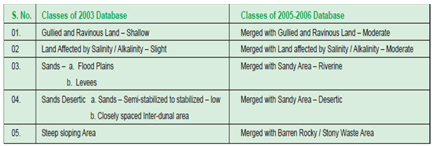
(Source: Degraded and Wastelands of India: Status and Spatial Distribution, 2010, Indian Council of Agricultural Research, New Delhi)
In India, land degradation poses problem mainly to agriculture and also to some other sectors such as housing, town planning, etc. To enable the use of the degraded lands, some mitigation measures are invariably required to be adopted. The statistics of variously degraded lands in the world are given in Fig. 2.1. Figure 2.2 shows the gully eroded lands in India. In some cases, mitigation measures may not be feasible such as in snow-covered lands (Fig. 2.3).
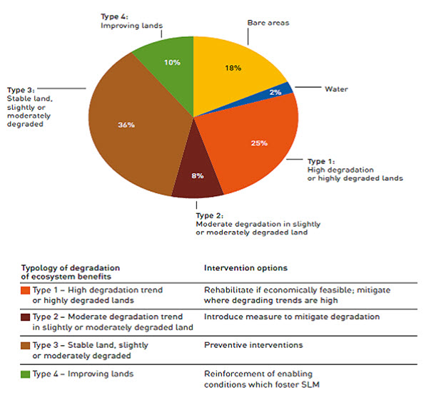
Fig. 2.1. Classification of Degraded Areas of the world of the world. (Source: http://www.fao.org/fileadmin/templates/solaw/files/thematic_reports/SOLAW_thematic_report_3_land_degradation.pdf)
Land use and land cover has become increasingly important as the Nation plans to overcome the problems of haphazard, uncontrolled development, deteriorating environmental quality, loss of prime agricultural lands, and destruction of important wetlands. Land use data are needed in the analysis of environmental processes and problems that must be understood if living conditions and standards are to be improved or maintained at current levels. Table 2.2 shows the land use classification In India as surveyed and reported by Ministry of Agriculture.
Table 2.2. Land Use Classification in India (2005-2006)
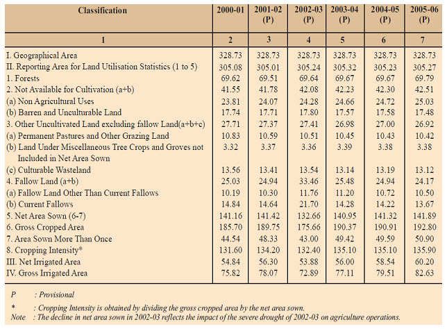
(Source: Agricultural Statistics at a Glance 2008, Ministry of Agriculture)
Figure 2.4 reveals that in India, the largest extent of land degradation occurs due to water erosion, followed by chemical problems of soil salinity, alkalinity and acidity and then by water logging. Besides natural water logging in high rainfall flat terrains, considerable water logging of agricultural lands takes place in the irrigation command areas, due to improper irrigation water management in water conveyance, distribution and application.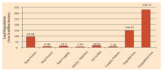
Fig. 2.4. Extent of Various Kinds of Land Degradation in India. (Source: State of Environment Report India-2009, Ministry of Environment & Forests, Government of India)
The soil degradation class based on area derived from 1: 250,000 soil map reveals that water erosion is the major problem in India and its effect on top soil is quite significant in comparison to other class of degradation, as shown in Table 2.4.
Table 2.4. NBSS&LUP soil degradation classes, derived from 1: 250,000 soil map (1985–1995)
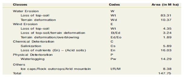
(Source: Degraded and Wastelands of India Status and Spatial Distribution, 2010, Indian Council of Agricultural Research New Delhi)
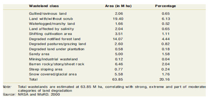
Wasteland map categories based on the area (M ha) gives the percentage of the area, according to surveyed total wasteland area of 63.85 M ha. Land without scrub (bare land) is more affected by erosion as shown in Table 2.5.
Table 2.5. Common categories of wasteland map (NRSA) and soil degradation map (NBSS&LUP)
(Source: Degraded and Wastelands of India Status and Spatial Distribution, 2010, Indian Council of Agricultural Research New Delhi)
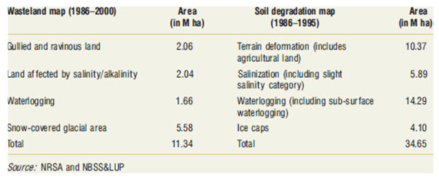
Table 2.6 shows that snow covered glacial areas are more degraded than gullied and ravine land as shown in soil degradation map (1986-2000). Water logging problem is also higher than other form of degradation.
Table 2.6. NRSA wasteland classes (1986–2000)
(Source: Degraded and Wastelands of India Status and Spatial Distribution, 2010, Indian Council of Agricultural Research New Delhi)
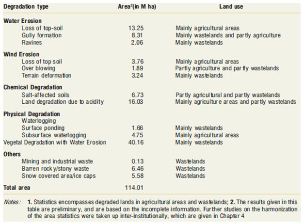
Statistic of degraded land are given in Table 2.7 based on land use, which conveys that water erosion and wind erosion affect mainly agricultural class due to loss of top soil and gully formation as found in mainly wasteland. Land degradation due to acidity is also high due to chemical in agricultural areas. Water logging is a severe problem which contributes 40.16 M ha in the form of physical degradation.
Table 2.7. Preliminary area statistics of degraded and wastelands of India
(Source: Degraded and Wastelands of India Status and Spatial Distribution, 2010, Indian Council of Agricultural Research New Delhi)
2.2 State-wise Affected Areas
State- wise degradation of land areas are given in the Table 2.8 and Table 2.9, in which degradation areas are divided into moderate, moderate severe, severe, very severe, extreme severe. It shows that Madhya Pradesh is having largest degraded area (km2) but the percentage of degraded area is high in Nagaland. Total percentage of degraded land of India is 39%. In Table 2.9 degraded lands are divided into two parts based on pH for water and wind erosion.
(a) 1- 9, for acid soil
(b) 10 - 19, for sodic soil
Table 2.8. State (region)-wise degraded land areas
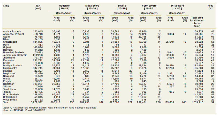
(Source: Degraded and Wastelands of India Status and Spatial Distribution, 2010, Indian Council of Agricultural Research New Delhi)
Table 2.9. State wise area statistics of degraded and wastelands of India
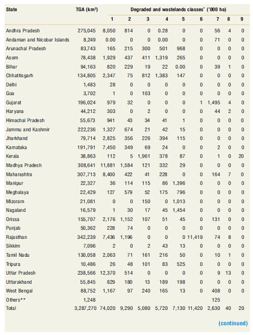
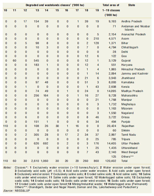
(Source: Degraded and Wastelands of India Status and Spatial Distribution, 2010, Indian Council of Agricultural Research New Delhi)
Last modified: Thursday, 19 September 2013, 5:22 AM