Site pages
Current course
Participants
General
Module 1:Water Resources Utilization& Irrigati...
Module 2:Measurement of Irrigation Water
Module 3: Irrigation Water Conveyance Systems
Module 4: Land Grading Survey and Design
Module 5: Soil –Water – Atmosphere Plants Intera...
Module 6: Surface Irrigation Methods
Module 7: Pressurized Irrigation
Module 8: Economic Evaluation of Irrigation Projec...
Topic 9
LESSON 1 Water Resources of India and its Demand in Various Sectors
1.1 Definition
Irrigation is defined as the science of artificial application of water to the land, in accordance with the ‘crop water requirements’ throughout the ‘crop period’ for full-fledged nourishment of the crops (Garg, 1996).
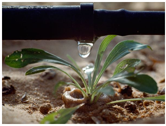
Fig. 1.1.Application of water by drip.
Irrigation water is supplied to supplement the water available from rainfall, soil moisture storage and capillary rise. However, in many cases, it is not possible to meet the full crop water requirement throughout the season due to limited water availability. In such cases, deficit irrigation is provided in the form of life saving or supplemental irrigation. Besides meeting the crop water requirement, irrigation is also provided for field preparation, climate control (crop cooling and frost control), and leaching of excessive salts.
Irrigation is very ancient practice and can be traced with the beginning of human civilization. Importance of irrigation in agriculture is very well documented in NamradaSmriti XI, 9 which states that “no grain is ever produced without water, but too much water tends to spoil the grain; an inundation is as injurious to crop growth as a dearth of water.” Hence, irrigation is essential.
Irrigation however has several advantages and disadvantages which are listed below:
Advantages
- Increases agricultural productivity and allows for multiple cropping during an year Provide jobs.
- Reduces risk of crop failures.
- Higher productivity results in steady supply of food at lower prices (supply demand principle of economics)
- Improves socioeconomic conditions of farmers
Disadvantages
- Excessive irrigation may cause decrease in crop yield
- Excessive irrigation may cause leaching of pesticide, insecticide, nitrogen and nitrates to groundwater and may also transport them to surface water systems.
- In poorly drained soils water logging and salinity may occur.
- In poorly maintained canals- excessive seepage may cause water logging.
- Excessive groundwater pumping may cause decrease in groundwater levels which may damage aquifer structure and increase the risk of land subsidence.
1.2 Purpose of Irrigation
Some of the main purposes of irrigation are enlisted below:
- To supply essential moisture for plant growth
- Transportation of fertilizers (Fertigation)
- To leach or dilute salts in soil
- To help in field preparation, dust control etc.
- Other benefits of irrigation include cooling of the soil and atmosphere to create more favourable environment for crop growth and frost control
1.3 Sources of Water
1.3.1 Natural Sources
Rain, snow, hail and sleet are precipitated upon the surface of the earth as meteorological water and may be considered as the original source of all the water supplied. Surface and groundwater are main sources of irrigation water. Three aspects should be considered in appraising water resources which are the quantity, the quality, and the reliability of availability of water. Rainwater, rivers, lakes, streams, ponds and springs are natural sources of water. Dams, wells, tube wells, hand-pumps, canals, etc. are man-made sources of water.
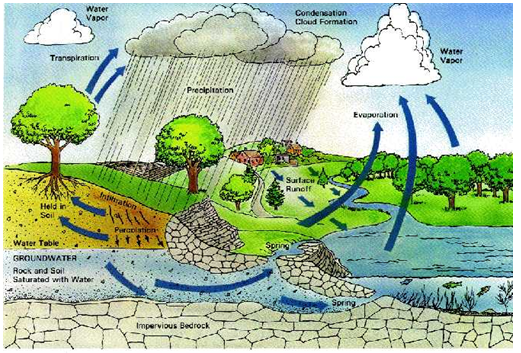
Fig. 1.2.Sources of water.
(Source:http://www.grandifloraservices.com/services/rain-water-harvesting/)
Irrigation water sources can be broadly classified into two main groups, namely,
- Surface water sources and
- Groundwater sources.
Irrigation water supply can be either obtained from surface water sources or groundwater sources or both. Both of these depend upon the precipitation.
1.3.2 Surface Water
Water present on the surface of the earth in the form of oceans, rivers, lakes, ponds and streams is called surface water. Surface water accumulates mainly by direct runoff from precipitation i.e., rain or snow melting. The amount of available surface water depends largely upon rainfall.
Surface water sources consists river, lake, and reservoir supplies. Dams or reservoirs are constructed to create artificial storage of water. Canals or open channels can be constructed to convey surface water from the rivers or reservoirs to the farm fields where it may directly applied to the field or stored in farm irrigation structures like ponds or tanks. The water is also conveyed through pipes by gravity or pumping.Thus, sources of surface water are i) Rivers and streams ii) Reservoirs iii) Tanks, ponds and lakes.
1.3.2.1 River
A river is a natural water course, usually of freshwater, flowing towards an ocean, a lake, a sea, or another river. In a few cases, a river simply flows into the ground or dries up completely before reaching another body of water.
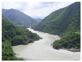
Fig. 1.3.River Ganga.
(Source:http://3.bp.blogspot.com: accessed on June 7, 2013)
1.3.2.2 Reservoir
A reservoir is a natural or an artificial lake, storage pond or impoundment from a dam which is used to store water. Reservoirs may be constructed across the rivers or may be excavated in the ground.
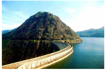
Fig.1.4. Reservoir. (Idukki Arch dam -Kerala, India).
(Source: http://2.bp.blogspot.com)
1.3.2.3 Lake
A lake is an inland water body of considerable size. Lakes can serve as the source or termination point for rivers or smaller streams. Lakes are distinct from lagoons as they are not part of the ocean. Lakes are larger and deeper than ponds.
1.3.2.4 Ponds
A pond is a body of standing water, either natural or man-made, that is usually smaller than a lake. Generally they contain shallow water with marsh and aquatic plants and animals.
1.3.2.5 Tank
Tanks are large excavations in which water is stored. They form an important source of water in many of the Indian villages.
1.3.3 Ground Water
A part of the water which infiltrates into the soil after any rainfall event percolates to the groundwater table. Groundwateris, generally, characterized by higher concentrations of dissolved solids, lower levels of colour, higher hardness (as compared with surface water), dissolved gasses and freedom from microbial contamination. Wells are generally used to extract groundwater.
The extraction of groundwater is mainly by:
1. Dug well with or without straining walls
2. Dug cum bore wells
3. Cavity Bore
4. Radial collector wells
5. Infiltration galleries
6. Tube wells& bore wells.
Groundwater that flows naturally from the ground is called a spring.
1.4 Present Status, Development and Utilization of Water Resources
1.4.1 Surface Water
In India, surface flow takes place through 14 major rivers basins. In addition to major rivers there are 44 mediumand 55 minor basins. The total water potential of these basins is estimated at 187.9 million ha million. A break up of this resource reveals that 105 million ha m is the runoff from rainfall that flows into rivers and streams including reservoir and tanks. The largest potential of water is available in Ganga-Brahmaputra-Meghna basin with a total of 117 million ha m followed by Godavari and west flowing rivers from Tapi to Tadri each having an average annual potential of more than 10 Mha m.
1.4.2 Ground Water
Ground water resources are abundant only in the northern and coastal plains. Agriculture is the major source of groundwater use. It has been found that excessive use of ground water depletes aquifers, lowers the water table and may lead to salivation, water logging and alkalization of the soils.
In India, the total utilizable water resource is assessed as 1123 Billion Cubic Meters(BCM) (Table 1.1). Keeping a provision of about 71 BCM/year out of 433 BCM of groundwater, 362 BCM/year of the resource is estimated to be available for irrigation. The net draft of groundwater for irrigation is around 150 BCM/yr. The per capita availability of water at national level has been reduced from about 5177 cubic meters in 1951 to the estimated level of 1,820 cubic meters in 2001 with variation in water availability in different river basins. Given the projected increase in population by the year 2025, the per capita availability is likely to drop to below 1,000 cubic meters, which could be labelled as a situation of water scarcity (GOI, 2006).
In the major part of the country, rainfall is the only sources for water which is available mainly during the monsoon season lasting for less than 3 months. Due to tropical climate and its geographical location, the country experiences vast spatial and temporal variation in precipitation. About one- third of the country's area is drought prone. The south and western parts comprising the states of Rajasthan, Gujarat, Andhra Pradesh, Madhya Pradesh, Maharashtra, Tamil Nadu and Karnataka are the drought prone areas. On the other hand, north and north eastern regions including states of Uttar Pradesh, Bihar, West Bengal and Assam are subjected to periodic flooding.
The total availability of water in the 76 major reservoirs was 109.77 BCM at the end of the monsoon of 2005 (GOI, 2006). The Central Ground Water Board (CGWB) has estimated that it is possible to increase the groundwater availability by about 36 BCM, by taking up rainwater harvesting and artificial recharge over an area of 45 M ha through surplus monsoon runoff. Thus, the groundwater availability may correspondingly increase.
The recent estimates (GOI, 2006) on water demand are made by a) Standing Sub-Committee of the Ministry of Water Resources (MoWR) and b) the National Commission for Integrated Water Resources Development (NCIWRD); their estimates (shown in Table 1.2) are made till the year 2050.The estimates by MoWR indicates that, by year 2050, the demand for water will increase by 5 times for industries, 16 times for energy production, while its drinking water demand will double, and irrigation demand will raise by 50 percent.
Table 1.1. Availability of Water Resources in India
|
Sr. No |
Particulars |
Quantity (Billion Cubic Meter) |
|
1. |
Annual Precipitation (Including snowfall) |
4000 |
|
2. |
Average Annual Availability |
1869 |
|
3. |
Per Capita Water Availability (2001) |
1820 |
|
4. |
Estimated Utilizable Water Resources |
1123 |
|
(i) Surface Water Resources |
690 km3 |
|
|
(ii) Ground Water Resources |
433 km3 |
|
(Source:www.wrmin.nic.in )
Table 1.2 Water Demand (in BCM) for various Sectors
|
Sector |
Standing Sub-Committee of MoWR |
NCIWRD |
||||
|
Year |
2010 |
2025 |
2050 |
2010 |
2025 |
2050 |
|
Irrigation |
688 |
910 |
1072 |
557 |
611 |
807 |
|
Drinking Water |
56 |
73 |
102 |
43 |
62 |
111 |
|
Industry |
12 |
23 |
63 |
37 |
67 |
81 |
|
Energy |
5 |
15 |
130 |
19 |
33 |
70 |
|
Others |
52 |
72 |
80 |
54 |
70 |
111 |
|
Total |
813 |
1093 |
1447 |
710 |
843 |
1180 |
(Source: GOI, 2006)
Key Words: Water Resources, Sources of Water, National Commission for Integrated Water Resources Development,Water Demand, Water Availability.
References
Garg, S. K. (1996). Irrigation Engineering and Hydraulic Structures, Khanna Publishers, Delhi, Twelfth Edition.
Government of India (2006). Report of the Working Group on Water Resources
for the XI the Five Year Plan (2007-2012). Ministry of Water Resources, Govt. of India.
Jha, B.M. and Sinha, S.K.,Towards Better Management of Ground Water Resources in India, Central Ground Water Board, Haryana.
Internet References
http://wrmin.nic.in/index2.asp?sublinkid=290&langid=1&slid=412
http://wrmin.nic.in/index2.asp?sublinkid=289&langid=1&slid=332
http://www.preservearticles.com/2012030625165/important-facts-on-water-resources-of-india.html
Suggested Reading
Michael, A.M. (2008). Irrigation Theory and Practice. Vikas Publishing House Pvt Ltd., Delhi.
http://www.fao.org/docrep/u5835e/u5835e03.htm
http://www.angrau.ac.in/media/10970/ageng151theory.pdf
Last modified: Wednesday, 16 April 2014, 5:23 AM