Site pages
Current course
Participants
General
Module 1:Water Resources Utilization& Irrigati...
Module 2:Measurement of Irrigation Water
Module 3: Irrigation Water Conveyance Systems
Module 4: Land Grading Survey and Design
Module 5: Soil –Water – Atmosphere Plants Intera...
Module 6: Surface Irrigation Methods
Module 7: Pressurized Irrigation
Module 8: Economic Evaluation of Irrigation Projec...
Topic 9
LESSON 4 Environmental Impact Assessment & Inter Basin Water Transfer
4.1 Environmental Impact Assessment
All water resource projects, whether for irrigation or for hydro-electric power or for flood control or for water supply have definite impact on the surrounding ecosystems and environment. If the projects are properly planned and suitably designed, the adverse impacts can be minimized. Environmental evaluation or assessment is generally done at the planning and design stages of the project. There is a need to develop a complete checklist of the impacts and an environmental evaluation system to quantify the impacts of irrigation projects.
4.1.1 Definition and Purpose
The purpose of the assessment is to ensure that decision makers consider the ensuing environmental impacts when deciding whether or not to proceed with a project. The International Association for Impact Assessment (IAIA) defines an EIA as "the process of identifying, predicting, evaluating and mitigating the biophysical, social, and other relevant effects of development proposals prior to major decisions being taken and commitments made". EIA has three main functions (FAO, 53):
to predict problems,
to find ways to avoid them, and
to enhance positive effects
The aim of an EIA is to ensure that potential impacts are identified and addressed at an early stage in the projects planning and design. The assessment finding are communicated to all the relevant groups who will make decisions about the proposed projects, the project developers and their investors as well as regulators , planners and the politicians. Having read the conclusions of an environmental impact assessment, project planners and engineers can shape the project so that its benefits can be achieved and sustained without causing adverse impacts.
Objective of EIA
Immediate Objectives of EIA:
Improve the environmental design of the proposal.
Ensure that resources are used appropriately and efficiently.
Identify appropriate measures for mitigating the potential impacts of the proposal.
Facilitate informed decision making, including setting of the environmental terms and conditions for implementing the proposal.
Long Term Objectives of EIA:
Protect human health and safety.
Avoid irreversible changes and serious damages to the environment.
Safeguard valued resources, natural areas and ecosystem components.
Enhance the social aspects of the proposal.
4.1.2 History of EIA
EIA was made legislation in the US in the National Environmental Policy Act (NEPA) 1969 as part of a technical evaluation that would lead to an objective decision making. It has since evolved as it has been used increasingly in many countries around the world. As per Jay et al. (2006), EIA as it is practiced today, is being used as a decision aiding tool rather than decision making tool.
The Ministry of Environment and Forests (MoEF) of India has made a substantial effort in the implementation of the EIA in India. The main laws in action are the Water Act (1974), the Indian Wildlife (Protection) Act (1972), the Air (Prevention and Control of Pollution) Act (1981) and the Environment (Protection) Act (1986). The responsible body for this is the Central Pollution Control Board. EIA studies need a significant amount of primary and secondary environmental data. The primary data are those which need to be collected in the field to define the status of the environment (like air quality data, water quality data etc.). The secondary data are those data which have been collected over the years and can be used to understand the existing environmental scenario of the study area.
4.1.3 Status of EIA in India
The importance and role for EIA was formally recognized at the earth summit held at Rio conference in 1992. Principle 17 of the Rio declaration states that –“EIA as a national instrument shall be undertaken for the proposed activities that are likely to have significant adverse impact on the environment and are subject to a decision of a competent national authority”.
In India many of the developmental projects till as recently as the 1980s were implemented with very little or no environmental concerns. The environmental issues began receiving attention when a national committee on environmental planning and coordination was set up under the 4th five year plan. Till 1980, the subjects of environment and forests were the concern of the Department of Science and Technology and Ministry of Agriculture respectively. Later, the issues were formally attended by the Department of Environment which was established in 1980. This was then upgraded to the Ministry of Environment & Forest in 1985. In 1980, clearance of large projects from the environmental angle became an administrative requirement to the extent that the planning commission and the central investment board sought proof of such clearance before according financial sanction.
Five years later, guidelines for Environmental Assessment of river valley projects were issued by the Department of Environment and Forests, Government of India. These guidelines require various studies such as impacts on forests and wild life in the submergence zone, water logging potential, upstream and downstream aquatic ecosystems and fisheries, water related diseases, climatic changes and seismicity.
A major legislative measures for the purpose of environmental clearance was in 1994 when specific notification was issued under section 3 and rule 5 of the environment protection Act, 1986 called the “Environment Impact Assessment Notification 1994”.
The first step in seeking environmental clearance for a development project is to determine what statutory legislations apply to the particular project. The MOEF has brought out several notifications restricting the development of industries in specified ecologically sensitive areas. In addition there are also draft rules framed for the siting of industries.
Environmental clearance for development projects can be obtained either at the state level or at the central level depending on certain criteria concerning the characteristics of the project. However (regardless of where the final environmental clearance is obtained from), for most projects the consent must first be taken from the state pollution control board or pollution control committees in the case of union territories.
4.1.4 Main Steps in the EIA Process
The way in which an EIA is carried out is not rigid: it is a process comprising a series of steps.
Screening: First stage of EIA, which determines whether the proposed project, requires an EIA and if it does, then the level of assessment required. The output from the screening process is often a document called an Initial Environmental Examination or Evaluation (IEE).
Scoping: The process of determining the most critical issues is done in this stage. Scoping is important for two reasons. First, so that problems can be pinpointed early allowing mitigating design changes to be made before expensive detailed work is carried out. Second, to ensure that detailed prediction work is only carried out for important issues. The main EIA techniques used in scoping are baseline studies, checklists, matrices and network diagrams.
Prediction and Mitigation: Once the scoping exercise is complete and the major impacts to be studied have been identified the prediction and mitigation work can start. This stage forms the central part of an EIA. The aim is to introduce measures which minimize any identified adverse impacts and also to enhance the positive impacts. Some of the techniques used for prediction are Mathematical modelling and Expert advice where as Checklists, matrices, networks diagrams, graphical comparisons and overlays are mitigation techniques.
Management and Monitoring: The main output report called an Environmental Impact Statement contains a detailed plan for managing and monitoring the environmental impacts both during and after implementation of the project. The part of the EIS covering monitoring and management is often referred to as the Environmental Action Plan or Environmental Management Plan. The purpose of monitoring is to compare predicted and actual impacts, especially if the impacts are critical to the society or ecosystem or the scale of the impact cannot be accurately predicted.
Auditing: Finally, an audit of the EIA process is carried out some times after the implementation. The audit serves a useful feedback and learning function. The audit should include an analysis of the technical, procedural and decision-making aspects of the EIA.
Managing Uncertainty: An EIA involves prediction and thus uncertainty is an integral part. There are two types of uncertainties that associated with the EIAs viz. processes and predictions. For processes, the uncertainty lies in the proper assessment of the importance of the different aspects and in accepting or discarding of the recommendations. For predictions the uncertainty lies in the accuracy of the findings.
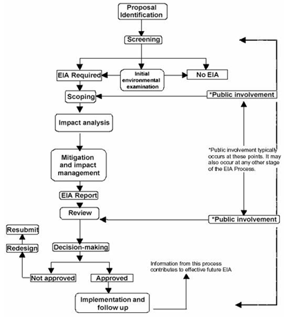
Fig. 4.1. EIA Process. (Source: http://old.cseindia.org/programme/industry/eia/introduction_eia.htm: accessed on June 18, 2013)
The three core values of any EIA study that have been identified till date are:
1. Integrity: The EIA process should be fair, objective, unbiased and balanced.
2. Utility: The EIA process should provide balanced, credible information for decision- making.
3. Sustainability: The EIA process should result in environmental safeguards which are sufficient to mitigate serious adverse effects and avoid irreversible loss of resource and ecosystem functions.
4.2 Inter Basin Water Transfer (IBWT)
Water transfer is one of the most important ways to eliminate water resources deficits and to solve water management problems.
4.2.1 The Need
The spatial and temporal variability of rainfall distribution results in surplus and deficit available water resources in many of the river basins in India at the same time. The river basins with surplus (largely unutilized) water resources often cause floods and hence submergence of crops whereas the river basins with lesser available water cause draughts. Making the required water (of proper quantity and quality) available at the place of need at the proper time is the duty of the government. These calls for the development and management of the water resources in an integrated and sustainable manner: equitably, economically and efficiently. This management process is broadly termed as Integrated Water Resources Development and Management which includes both within basin and inter-basin water transfer (Thatte, 2006).
4.2.2 Definition and Objective
Inter-basin water transfer (IWBT) schemes are used to describe man-made conveyance schemes which move water from one river basin where it is surplus, to another basin where water is scarce. The major objective of the proposed inter-basin transfer of water is to meet requirements of highly water deficit areas, where no other sources are available. IBWT projects are commonly proposed as solutions to water distribution and supply problems.
4.2.3 Emergence of Concept
The earliest linking works of river basin in India are the Periyar-Vaigai Project of late 19th century. Parambkulam-Aliyar Project, Kurnool-Cudappa canal and the recent Telugu Ganga Project are other examples. The concept of inter-basin transfer of water within India has been started for over 40 years with two independent inter-basin water transfer proposals. The first Dr. K. L. Rao’s proposal (1972) known as the ‘Ganga-Cauvery Link’ consisted of 2640 km link from Ganga near Patna to transfer the water to the south during high flow. Another proposal which received considerable publicity was that of Captain Dastur’s proposal (1977) known as the ‘Garland Canal Link’ consisted of a 4200 Km long ‘Himalayan Canal’ and a 9300 km long ‘Southern Garland Canal’. After study of these proposals, the Government of India in 1980 prepared a National Perspective Plan for interlinking the rivers. The plan comprises two components:
The Himalayan Rivers Development: The Himalayan river component envisages storages and interlinking canal systems to transfer surplus flows of the Kosi, Gandak and Ghagra to the west; Brahmaputra-Ganga link to augment the dry weather flows of the Ganga; Ganga-Yamuna link to serve the drought areas of Haryana, Rajasthan, Gujarat and also south Uttar Pradesh and south Bihar. This scheme will benefit not only parts of India but also neighbouring countries of Nepal and Bangladesh (NWDA, 1998).
- The Peninsular Rivers Development: Among the Peninsular rivers, the Mahanadi and Godavari are considered to have sizeable surpluses after meeting the existing and projected needs of the states within these basins. It is therefore, proposed to build terminal storages on Mahanadi and Godavari rivers to divert surplus flows of Mahanadi to the Godavari system and to further transfer surplus from the Godavari system to water short rivers namely, Krishna, Pennar and Cauvery. This component is divided into four major parts:
Interlinking of Mahanadi-Godavari-Krishna-Cauvery rivers and building storages at potential sites in these basins.
Interlinking of west flowing rivers, north of Mumbai and south of Tapi.
Interlinking of Ken-Chambal rivers.
Diversion of other west flowing rivers.
4.2.4 Classification of IBWT Projects (Proceedings of the International Workshop on Inter-basin Water Transfer, 1999)
At present, a great number of various water transfer systems operate or are under construction (local, intra-basin, inter-basin, inter-zonal, etc.). The amount of transferred volume (V) and distance (L) of the transfer are the most important characteristics of such systems. These components determine both the cost of the system and its impact on the environment. It is thus reasonable to classify the water transfer systems by using a combined index (V x L). The classification of water transfer projects by this indicator is shown in Table 4.1.
Table 4.1. Classification of water transfer projects according to its scale
|
Category of transfer |
Volume (V, km3/yr) |
Distance (L, km) |
Scale index (V x L, km3/yr.km) |
|
Small |
<1 |
<100 |
<100 |
|
Medium |
1-2.5 |
100-400 |
100-1000 |
|
Large |
2.5-5 |
400-1000 |
1000-5000 |
|
Very large |
5-10 |
1000-2500 |
5000-25000 |
|
Largest |
>10 |
>2,500 |
>25000 |
4.2.5 Some of the Existing Inter-basin Water Transfers Projects
Long distance inter basin transfer of water is not a new concept and has been in practice in India since long. The details for some of the existing links for inter-basin transfer of water are given Table 4.2.
Table 4.2. Some of Existing IBWT Projects in India
|
Project Name |
Location |
Description |
|
Periyar Project |
Southern India |
Transfer water from Periyar river in Kerala to the Vaigai basin in Tamil Nadu |
|
Parambikulam Aliyar Project |
Southern India |
Transfer water from Chalakudy river basin to the Bharatapuzha and Cauvery basins for irrigation in Coimbatore district of Tamil Nadu and the Chittur area of Kerala states |
|
Southern India |
Transfer water from Krishna River basin to the Pennar basin |
|
|
Southern India |
It brings Krishna River water through 406 km of canals |
|
|
Northern India |
Linking the Ravi river, the Beas river and the Sutlej river through a system of dams, hydropower plants, tunnels, canals and irrigation systems |
(Source: http://nwda.gov.in/index2.asp?slid=107&sublinkid=7&langid=1)
4.2.5 Environmental Impacts of Inter-basin Water Transfer Projects
In India, the planners are familiar with the social and environmental concerns caused by small, medium and large inter-basin projects. So, Environmental Assessment (EA) has become a necessary step in the evaluation of any major irrigation project, including IBWT projects. It was noted that EAs are sometimes simplified to safeguard water quality. Some of the impacts caused by IBWT projects are shown below:
These projects lead to inadvertent introduction of flora and fauna alien to the recipient basin from the donor basin. This introduced flora and fauna could theoretically grow to a proportion where it becomes a menace to the ecology of the recipient area and can disturb the ecological balances.
The large storages and long links could involve a much larger resettlement problem.
The link canals may involve large scale interruption of natural drainage and also a large barrier between neighbouring communities.
References
http://envfor.nic.in/divisions/iass/eia/Cover.htm
http://old.cseindia.org/programme/industry/eia/introduction_eia.htm
Michael, A.M. (2008). Irrigation Theory and Practice. Vikas Publishing House Pvt. Ltd., Delhi.
Suggested Reading
Last modified: Wednesday, 16 April 2014, 6:08 AM