Site pages
Current course
Participants
General
Module 1: Introduction and Concept of Soil Erosion
Module 2: Water Erosion and Control
Module 3: Wind Erosion, Estimation and Control
Module 4: Soil Loss- Sediment Yield Estimation
Module 5: Sedimentation
Module 6: Topographic Survey and Contour Maps
Module 7: Land Use Capability Classification
Module 8: Grassed Waterways
Module 9: Water Harvesting
Module 10: Water Quality and Pollution
Lesson 3 Erosion Due to Water
Erosion of soil by water is caused by its two forms: liquid as the flowing water, and solid as the glaciers.
3.1 Forms of Water Erosion
The impact of rainfall causes splash erosion. Runoff water causes scraping and transport of soil particles leading to sheet, rill and gully erosion. Water waves cause erosion of bank sides of reservoirs, lakes and oceans. The subsurface runoff causes soil erosion in the form of pipe erosion, which is also called tunnel erosion. The glacial erosion causes heavy landsides. In India, glacial erosions are mainly confined to Himalayan regions. The various forms of water erosion are given below.
3.1.1 Hydraulic Action: The hydraulic action takes place when water runs over the soil surface compressing the soil, as a result of which the air present in the voids exerts a pressure on the soil particles and this leads to the soil detachment. The pressure exerted by the air voids is called hydraulic pressure. The soil particles so detached from their places, are scoured by the running water. The hydraulic action is more effective when the soil is in loose condition.
3.1.2 Abrasion: Soil particles mixed with the running water create an abrasive power in the water which increases the capacity of flowing water to scour more soil particles. Due to this effect, larger soil particles are eroded by the flowing water.
3.1.3 Attrition: This form includes mechanical breakdown of loads running along the moving water due to collision of particles with each other. The broken particles are moved along with the flow velocity, which generate abrasion effect on the bottom and banks of the water course. This effect pronounces the water erosion.
3.1.4 Solution: This form is associated with the chemical action between running water and soil or country rocks. This type condition is observed in areas where existing rocks or soils are easily dissolved in the running water.
3.1.5 Transportation: The process of soil transportation by running water is completed under the following forms:
1) Solution: the water soluble contents present in the water are transported by the water in solution form.
2) Suspension: it involves the transportation of finer soil particles, which are present in suspension form in the flowing water.
3) Saltation and Surface Creep: it involves transportation of medium size soil particles that are not able to stand in suspension form, but are mixed in water and flow over the stream bed in the form of mud. The surface creep action is responsible for transporting the coarser soil particles.
3.2 Factors Affecting Water Erosion
Water erosion is due to dispersive and transporting power of the water; as in case of water erosion first soil particles are detached from the soil surface by the raindrop force and then transported with surface runoff. There is a direct relationship between the soil loss and surface runoff volume. The water erosion process is influenced primarily by climate, topography, soils and vegetative cover. The factors influencing the water erosion are discussed below.
3.2.1 Climatic Factors: Climate includes rainfall, temperature and wind. The frequency, intensity and duration of rainfall are the principal aspects of rainfall influencing the volume of runoff, erosion and sediment (potential) from a given area. As the volume and intensity of rainfall increase, the ability of water to detach and transport soil particles increases. When storms are frequent, intense, and of long duration, the potential for erosion of bare soils is high. Temperature has a major influence on soil erosion. Frozen soils are relatively erosion resistant. However, bare soils with high moisture content are subject to uplift or “spew” by freezing action and are usually easily eroded upon thawing. Wind contributes to the drying of soil and increases the need for irrigation for new plantings and for applying wind erosion control practices.
3.2.2 Soil Characteristics: Soil characteristics include texture, structure, organic matter content and permeability. In addition, in many situations, compaction is significant. These characteristics greatly determine the erodibility of soil. Soils containing high percentages of sand and silt are the most susceptible to detachment because they lack inherent cohesive characteristics. However, the high infiltration rates of sands either prevent or delay runoff except where overland flow is concentrated. Clearly, well-graded and well-drained sands are usually the least erodible soils in the context of sheet and rill erosion. Clay and organic matter act as a binder to soil particles, thus reducing erodibility. As the clay and organic matter content of soils increase, the erodibility decreases. However, while clays have a tendency to resist erosion, they are easily transported by water once detached. Soils high in organic matter resist raindrop impact, and the organic matter also increases the binding characteristics of the soil. Sandy and silty soils on slopes are highly susceptible to gully erosion where flow concentrates because they lack inherent cohesiveness. Small clay particles, referred to as colloids, resist the action of gravity and remain in suspension for long periods of time. Colloids are potentially a major contributor to turbidity where they exist.
3.2.3 Vegetation Cover: Vegetative cover is an extremely important factor in reducing erosion at a site. It absorbs energy of raindrops, binds soil particles, slows down the velocity of runoff water, increases the ability of a soil to absorb water, removes subsurface water between rainfall events through the process of evapotranspiration and reduces off-site fugitive dust. By limiting the amount of vegetation disturbance and the exposure of soils to erosive elements, soil erosion can be greatly reduced. Vegetations create a surface obstruction for direct falling of raindrops on the land surface as well as in the flowing path of surface runoff. A good vegetative cover completely negates the effect of rainfall on soil erosion.
3.2.4 Topographic Effect: The main topographic factors which influence the soil erosion are land slope, length of slope and shape of slope. The land slope or slope inclination affects the erosion predominantly. As the slope increases, the runoff coefficient, kinetic energy and carrying capacity of surface runoff also increase thereby decreasing the soil stability. Critical slope length is the slope length at which the soil erosion begins. It is related to the critical land inclination. Lower the critical inclination larger will be the critical slope length. The slope shapes have greater bearing on erosion potential. The base of a slope is more susceptible to erosion than the top, because runoff has more momentum and is more concentrated as it approaches the base of slope. The slopes may be roughly convex or concave. On convex slope the above phenomena is magnified, whereas on concave slope it is reduced. It is because in convex slope, the steepness increases towards bottom, while it is flattened towards bottom in case of concave slope.
3.3 Types of Water Erosion
Water erosion can be classified as splash erosion, sheet erosion, rill erosion, gully erosion, stream bank erosion, sea-shore erosion and land slide erosion. They are discussed as follows.
3.3.1 Splash Erosion: It is also known as raindrop erosion (Fig. 3.1) because it is caused by the impact of raindrops on exposed soil surface. The process of raindrop erosion can be described as: when raindrop strikes on open soil surface it forms a crater. This is accomplished by forming a blast which bounces the water and soil up and returns back around the crater. The soil may be splashed into the air up to a height of 50 to 75 cm depending upon the size of rain drops. At the same time the soil particles also move horizontally as much as 1.50 m on level land surface. On sloping land, more than half of the splashed particles move down with the runoff.
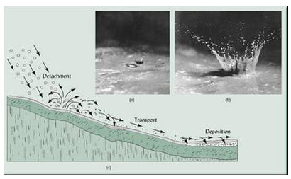
Fig. 3.1. Splash erosion. (Source: www.bierbrauerf.weebly.com)
3.3.2 Sheet Erosion: Sheet erosion may be defined as more or less uniform removal of soil in the form of a thin layer or in “sheet” form by the flowing water form a given width of sloping land (Fig. 3.2). It is an inconspicuous type of soil erosion because the total amount of soil removed during any storm is usually small. In the sheet erosion two basic erosion processes are involved. First process is the one in which soil particles are detached from the soil surface by falling of raindrop and in the second one the detached soil particles are transported away by surface runoff from the original place. The detached process is referred to as the splash erosion and transportation of detached particles by flowing water is considered as the wash erosion. When the rate of rainfall exceeds the infiltration rate of the soil, the excess water tends to flow over the surface of sloping land. This flowing water also detaches soil particles from the land surface and starts flowing in the form of thin layer over the surface. The erosion during these processes is called sheet erosion. The eroding and transporting power of sheet flow depends on the depth and velocity of flowing water for a given size, shape and density of soil particles.
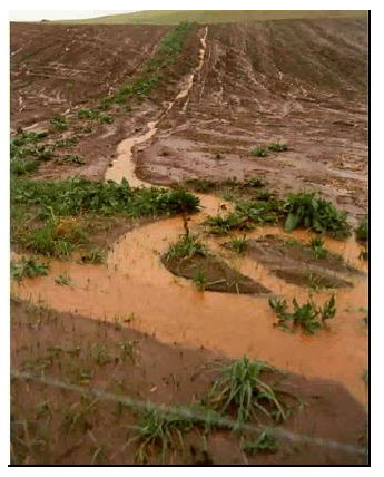
Fig. 3.2. Sheet erosion. (Source: www.soer.justice.tas.gov.au)
3.3.3 Rill Erosion: This type of water erosion is formed in the cultivated fields where the land surface is almost irregular. As the rain starts, the water tends to accumulate in the surface depressions and begins to flow following least resistance path. During movement of water large amount of soil particles are eroded from the sides and bottom of the flow path, which are mixed in the flowing water. This surface flow containing soil particles in suspension form moves ahead and forms micro channels and rills (Fig. 3.3).
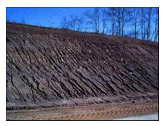
Fig. 3.3. Rill erosion. (Source: http://www.kalkaskacounty.net)
3.3.4 Gully Erosion: Rills are small in size and can be leveled by tillage operations. When rills get larger in size and shape due to prolonged occurrence of flow through them and cannot be removed by tillage operation, these are called gullies (Fig. 3.4). Large gullies and their network are called ravines. It is the advanced and last stage of water erosion. In other words it is the advanced stage of rill erosion. If the rills that are formed in the field are overlooked by the farmers, then they tend to increase in their size and shape with the occurrence of further rainfall. Some of the major causes of gully erosion are: steepness of land slope, soil texture, rainfall intensity, land mismanagement, biotic interference with natural vegetation, incorrect agricultural practices, etc. Gully erosion gets initiated where the longitudinal profile of an alluvial land becomes too steep due to sediment deposition. Gullies advance due to the removal of soil by the flowing water at the base of a steep slope, or a cliff at the time of fall of stream. High intensity of flow of the runoff increases the gully dimensions. In the absence of proper control measures, slowly the gullies extend to nearby areas and subsequently engulf the entire region with a network of gullies of various sizes and shapes.
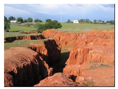
Fig. 3.4. Gully erosion. (Source: www.soilsurvey.com.au)
3.3.5 Stream Bank Erosion: Stream bank erosion is defined as the removal of stream bank soil by water either flowing over the sides of the stream or scouring from there (Fig.3.5). The stream bank erosion due to stream flow in the form of scouring and undercutting of the soil below the water surface caused by wave action is a continuous process in perennial streams. Stream bank erosion is mainly aggravated due to removal of vegetation, over grazing or cultivation on the area close to stream banks. Stream bank erosion is also caused by the occurrence of flood in the stream. Apart from scouring, the sloughing is also a form of stream bank erosion which is caused when the stream water subsides after reaching the peak. Sloughing is mainly due to movement of underground water from side into the stream due to pressure difference.
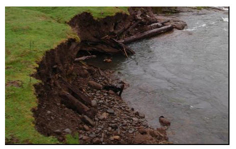
Fig. 3.5. Stream bank erosion. (Source: www.sswc.org)
3.3.6 Sea-shore Erosion: It is also called coastal erosion. Sea shore erosion is the wearing away of land and the removal of beach or dune sediments by wave action, tidal currents, wave currents, or drainage (Fig. 3.6). Waves, generated by storms, wind or fast moving motor craft, cause coastal erosion which may take the form of long-term losses of sediment and rocks, or merely the temporary redistribution of coastal sediments. It may be caused by hydraulic action, abrasion, impact and corrosion.
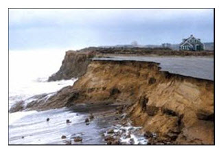
Fig. 3.6. Sea-shore/ coastal erosion. (Source: www.climatide.wgbh.org)
3.3.7 Landslide Erosion: When gravity combines with heavy rain or earthquakes, whole slopes can slump, slip or slide (Fig. 3.7). Slips occur when the soil (topsoil and subsoil) on slopes becomes saturated. Unless held by plant roots to the underlying surface, it slides downhill, exposing the underlying material.
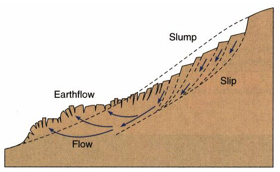
Fig. 3.7. Cross-section of landslide characteristics.
(Source: www.drstoney.wikispaces.com)
Key words: Soil, erosion, Cover, climate, Landslide erosion, Gully erosion
References
www.soer.justice.tas.gov.au.
www.kalkaskacounty.net.
www.climatide.wgbh.org.
Suggested readings
Suresh, R. (2009). Soil and Water Conservation Engineering, Standard Publishers Distributors, Delhi, pp. 101-134.
Murthy, V.V.N. (1994). Land and Water Management Engineering, Kalyani Publishers, New Delhi.
Mal, B.C. (1995). Introduction to Soil and Water Conservation Engineering, Kalyani Publishers, New Delhi.
Last modified: Wednesday, 18 December 2013, 9:12 AM