Site pages
Current course
Participants
General
Module 1_Fundamentals of GW
Module 2_Well Hydraulics
Module 3_Design, Installation and Maintenance of W...
Module 4_Groundwater Assessment and Management
Module 5_Principle, Design and Operation of Pumps
Module 6_Performance Characteristics, Selection an...
Keywords
Lesson 2 Occurrence of Groundwater
2.1 Vertical Distribution of Subsurface Water
In order to understand the occurrence of groundwater and its vertical distribution, let’s first consider the hydrological zones present below the ground (Fig. 2.1). The zone between the ground surface and the top of capillary fringe is called unsaturated zone (or, zone of aeration) which consists of voids (pores or interstices) partially filled with water and partially with air. Water is held at a pressure less than the atmospheric pressure in the unsaturated zone. The zone between bottom of the unsaturated zone and top of the water table is called capillary zone, wherein most voids are filled with water but the water is held at a pressure less than the atmospheric pressure. Finally, the zone extending from the water table to an impermeable layer is called saturated zone (or, zone of saturation), wherein all voids are completely filled with water. In this zone, water is held at a pressure greater than the atmospheric pressure, and hence it moves in a direction based on the contiguous hydraulic situation.
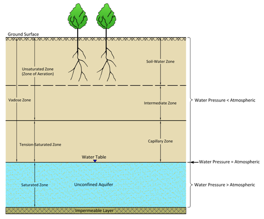
Fig. 2.1. Hydrologic zones below the ground.
(Source: Modified from Sanders, 1998)
The unsaturated zone can be further sub-divided into ‘soil-water zone’ and ‘intermediate zone’ (Todd, 1980). The zone between the ground surface and the top of water table is known as the vadose zone. Thus, the vadose zone consists of unsaturated zone and capillary zone (also known as ‘capillary fringe’). The water present in the vadose zone is called vadose water which is held at a pressure less than the atmospheric pressure. Hence, while this water is still able to move within the vadose zone due to matric potential and gravity, it cannot move out of the zone into wells, pits, or other water collection systems that are exposed to the atmospheric pressure. Note that the term vadose zone is technically more appropriate than the conventional term unsaturated zone. This is because portions of the vadose zone may actually be saturated, even though the pressure of water is below the atmospheric pressure. Hence, the term vadose zone has become popular and is widely used these days in the fields of groundwater hydrology and soil physics.
Broadly speaking, the water stored in the zone of saturation is called groundwater. Not all underground water is groundwater, rather only free water or gravitational water (the water that moves freely under the force of gravity into wells) constitutes the groundwater. Therefore, a precise and practical definition of groundwater is (Bouwer, 1978): “Groundwater is that portion of the water beneath the earth’s surface, which can be collected through wells, tunnels, or drainage galleries, or which flows naturally to the earth’s surface via seeps or springs”. Depths to groundwater may range from 1 m or less to 1000 m or more. There are also places where groundwater does not exist at all.
2.2 Types of Subsurface Formations
In subsurface hydrology, the material present below the ground is normally called subsurface formation or subsurface deposit. Subsurface formations can be divided into two broad groups: (a) soil, and (b) geologic formations. As we know that the soil is formed by weathering of rocks. However, geologic formations can be consolidated, semi-consolidated and unconsolidated formations. Consolidated geologic formations are the rocks formed by cementation, compaction and recrystallisation, and their grains are tightly held together. They are also known as ‘hard rocks’. Examples of consolidated geologic formations are igneous and metamorphic rocks such as granite, basalt and schist, and indurated sedimentary rocks such as sandstone, shale and limestone. Semi-consolidated geologic formations are sedimentary rocks wherein the induration process is incomplete and the primary porosity (intergranular porosity) is preserved to a varying degree. Among the semi-consolidated sedimentary rocks, sandstone is considered most productive because in an early stage of cementation, its primary porosity is very high like sand. On the other hand, unconsolidated geologic formations are comprised of non-indurated colluvial, alluvial, aeolian (wind-borne sediments), lacustrine, marine (coastal) and glacial deposits. These formations/deposits consist of sand, silt, clay, gravel and pebbles.
2.3 Aquifer and Confining Layers
From the groundwater viewpoint, geologic formations can be sub-divided into: (i) aquifer layers (or aquifers), and (ii) confining layers. Literally, aquifer means ‘water-bearing formation’. In subsurface hydrology (hydrogeology), an aquifer is defined as “a single geologic formation or a group of geologic formations that can transmit and yield water in usable quantities”. Aquifers are the target for all groundwater exploration and development programs. The intrinsic permeability (k) of aquifers is greater than 10-2 darcy.
Many types of geologic formations serve as aquifers. Unconsolidated geologic formations (e.g., alluvial deposits) and semi-consolidated geologic formations serve as aquifers because of primary porosity (i.e., intergranular porosity), while consolidated geologic formations (i.e., hard rocks) serve as aquifers primarily due to secondary porosity caused by fractures, fissures, solution cavities/channels, lava tubes, shrinkage cracks, etc. The geologic formations having potential for aquifers are: alluvial deposits, limestone, volcanic rocks, sandstone, and weathered igneous and metamorphic rocks. On the other hand, conglomerates, and solid igneous and metamorphic rocks mostly serve as bedrocks or confining layers. Clay, silt and coarser particles mixed with clay and/or silt are usually porous, but their pores are so small that they are practically regarded as semi-permeable or impermeable in most cases. They better serve as leaky or non-leaky confining layers. Note that the lithology, stratigraphy and structure of rock formations control the horizontal and vertical extent and the nature of aquifers or confining layers.
In hydrogeology, the geologic formations which are not aquifers are termed confining layers. A confining layer is defined as (Fetter, 2000): “A geologic formation having little or no intrinsic permeability”. Confining layers could be grouped as ‘leaky confining layers’ or ‘non-leaky confining layers’ (Fetter, 2000) depending on whether they can contribute significant leakage through them or not. Confining layers have an intrinsic permeability (k) of less than 10-2 darcy; it is an arbitrary limit and depends on local conditions (Fetter, 2000). For example, in areas of clay (k = 10-4 darcy), a layer of silt of 10-2 darcy might be used to supply water to a small well. On the other hand, the same silty layer might be considered a confining layer, if it were found in an area of coarse gravels with k = 100 darcys. In fact, groundwater moves through most confining layers, but the rate of movement is very slow. Traditionally, confining layers are classified as aquitards, aquicludes and aquifuges. However, the terms ‘non-leaky confining layer’ and ‘leaky confining layer’ are becoming popular in subsurface hydrology in order to distinguish whether a confining layer is non-leaky or leaky in nature.
Aquiclude is defined as a geologic formation that can store significant amount of water but does not have the capability to transmit a significant amount of water. Clay is an ideal example of aquiclude. Aquitard is defined as a geologic formation that can store some water as well as can transmit water at a relatively low rate compared to aquifers. Although an aquitard may not yield water economically, it can hold appreciable amounts of water. Sandy clay is an ideal example of aquitard. On the other hand, aquifuge is defined as a geologic formation that can neither store nor transmit water. Solid granite is an ideal example of aquifuge. Thus, aquifuge is essentially a non-leaky confining layer, whereas aquitards and aquicludes are essentially leaky confining layers. In practice, however, aquiclude is often considered as a non-leaky confining layer because leakage through aquicludes is generally very small which can be considered practically insignificant.
2.4 Origin and Age of Groundwater
Almost all groundwater can be considered as a part of the water cycle. Relatively small amount of groundwater may enter the water cycle from other origins, which is often called generic types of groundwater namely magmatic water, connate water, juvenile water and metamorphic water (Todd, 1980).
The water originated from magma is called magmatic water. The magmatic water available at relatively shallow depths (probably 3 to 5 km) is known as volcanic water and when it is available at deeper depths (>3 or 5 km), it is called plutonic water. Connate water is the water present in the interstices of fossils (remains of buried animals or that have hardened into rocks) and has been out of contact with the atmosphere for considerable time of a geologic period. This water might have been derived from oceanic or freshwater sources and is highly mineralized. Juvenile water is the water that has not earlier been a part of the hydrosphere. It is derived from magma or atmosphere. Finally, metamorphic water is the water associated with rocks during metamorphism process.
The water presently withdrawn from an aquifer (e.g., deep and extensive aquifers) might have entered the aquifer thousands of years ago. For instance, an analysis of the groundwater samples from deep wells in deserts of the United Arab Republic and Saudi Arabia indicated groundwater ages of 20,000 to 30,000 years (Todd, 1980). Investigation of the residence time of water under the ground (i.e., age of groundwater) is known as ‘age-dating’. The radioisotopes tritium (H-3) and carbon-14 (C-14) have been found to be very useful for estimating the age of groundwater. Tritium is applicable for estimating groundwater residence times of up to 50 years, whereas carbon-14 is applicable for estimating groundwater residence times of several hundred years to about 50,000 years (Todd, 1980).
2.5 Groundwater Regions of India
About two thirds of the total land area in India comprises consolidated formations, of which 75% is made up of crystalline rocks and consolidated sediments and the remaining 25% is trap (Raghunath, 2007). The remaining one third of the total land area comprises semi-consolidated and unconsolidated formations like alluvial tracts. Potential areas of groundwater in India are illustrated in Fig. 2.1 and their brief description is given below (Raghunath, 2007).
(1) Himalayan Highlands
All types of rocks are present in this region. Major rock types present in the Himalayan Highlands are granites, basalts, sandstones, limestones, shales, conglomerates, slates, quartzites, gneisses, schists and marbles. Favourable conditions exist with springs forming a major part of water supply in this region.
(2) Kashmir Valley
The Kashmir Valley which was a vast lake during the Pleistocene times shows a large scale development of freshwater sediments of lacustrine, fluvial and glacial origin.
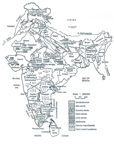
Fig. 2.1. Groundwater regions of India. (Source: Raghunath, 2007)
(3) Indo-Gangetic Alluvium
This region consists of coarse sands, gravel and boulders of variable thickness (3 to 60 m), and constitutes a vast reservoir of fresh groundwater. The exploitation of groundwater is usually done by using augers, hand boring, cable tool and rotary rigs.
(4) Coastal Alluvium (Malabar and Coromandel Coastal Areas)
The depth of aquifers varies from 15 to 150 m. Because of increasing groundwater exploitation in this region, extensive saline patches occur in Ramnad, Tirunelveli, Ongole, Nellore, and Krishna districts. In Ramanathapuram and Tirunelveli, the groundwater available in the unconfined aquifers is usually of poor quality with a chloride (Cl) concentration of >1000 ppm (mg/L) and at some places, the Cl concentration is even >3000 ppm (mg/L). However, in the west coast areas of Kerala and Karnataka, the substratum is mostly lateritic and a good yield of groundwater is expected.
Saline water influx in response to tides has been observed at places in Goa, up to a distance of 25-40 km inland. In the upper reaches, the tidal streams show cyclic fluctuations in water salinity, with the highest salinity during high tides and the lowest salinity during low tides.
(5) Cretaceous Sandstones of Kathiawar and Kutch Areas
This region has moderately potential aquifers with depths ranging from 100 to 300 m, and the yield approximately10-120 m3/h. Groundwater is normally brackish with a TDS of 2000-5000 ppm (mg/L). In Gujarat, sandstone aquifers exist at depths of 60 to 200 m, with a yield of about 10-50 m3/h and a TDS of 1000-2500 ppm.
(6) Mesozoic Sandstones of Lathi Region in Rajasthan (Jaisalmer, Barmer and Bikaner)
It contains moderately potential aquifers with depths ranging from 100 to 150 m, and a yield of about 45-150 m3/h. Groundwater is generally brackish to saline, with TDS = 1000-5000 ppm, Cl = 1000-5000 ppm, EC (electrical conductivity) >3000 µmhos/cm, Na Percentage >80, and SAR (Sodium Adsorption Ratio) = 25-55.
(7) Cavernous Limestones of Vindhyan System in Borunda and Ransingaon Areas in Jodhpur District
Potential aquifers are fractured up to 150 m, and have a yield of 40-70 m3/h. Groundwater has TDS < 2000 ppm and is potable.
(8) Doon Valley Gravels
The Doon Valley region has boulders, pebbles, gravel, sand and clay possibly of fanglomeratic and colluvial origin. Major portion of the valley is hilly having sloping ground. Hence, only the central part (approximately 388 km2 which is about one-fifth of the total area of 2090 km2) can be developed for groundwater exploitation. Thickness of the fill is 150-200 m and the well yield varies from 30 to 150 m3/h. The quality of groundwater is bicarbonate to sulphate type, with TDS = 100-500 ppm, Cl >30 ppm and pH = 7.8. In the Terai zone, groundwater is available under artesian conditions at shallow depths of 3 to 50 m. Sand and gravel layers confined between silty and clayey layers constitute good confined aquifers.
(9) Quaternary Alluvium of Narmada, Purna, Tapti, Chambal and Mahanadi Rivers
This region contains lenses of sand and gravel having a thickness of 75 to 150 m. Tubewell yield varies from 20 to 150 m3/h. Groundwater quality is good with a TDS of 100-500 ppm.
(10) Vesicular Basalts in the Deccan Trap Formations of Maharashtra and Madhya Pradesh
This region contains good aquifers, with groundwater occurring under both confined and unconfined conditions in the Satpura range and Malwa plateau. Tubewell yields in Indore, Bhopal, Raisen, Vidisha and Sagar districts range between 10 and 40 m3/h (approximately). In central Maharashtra, the yield of the tubewells drilled in weathered basalts is about 2-10 m3/h, while in exceptional cases the well yields are ≈ 25 m3/h, mostly within depths of 50 to 100 m. Borewells mainly serve as a source of drinking water supply because of their low yield, and only in exceptional cases they are used for irrigation. The quality of groundwater is good (TDS < 1000 ppm) for all uses.
(11) Carbonate Rocks with Solution Cavities in Madhya Pradesh
In the Vindhyan, Cuddapah and Bijawar region, the carbonate rocks with interconnected solution cavities and caverns form good aquifers. The limestones of Raipur, Charmuria, Kajrahat (Sidhi district), Karstic areas of Chhatisgarh basin and Baghelkhand region of Madhya Pradesh yield water about 10-60 m3/h.
(12) Dharwarian and Bundelkhand Granite Region of Madhya Pradesh
This region comprises igneous and metamorphic rocks, wherein water moves mainly through joints and openings (secondary porosity) present in these rocks. The yields of the tubewells in Tikamgarh, Chattarpur, Balaghat and Gwalior area are approximately 10-30 m3/h; they tap mostly unconfined aquifers. The quality of groundwater in all the regions of Madhya Pradesh is normally good.
(13) Tertiary Sandstones and Quaternary Sand to Pebble Beds in the Godavari-Krishna Interstream Area
This region contains potential aquifers under artesian/confined conditions. Aquifer thickness varies from 3 to 184 m and the tubewell yields range from 20 to 120 m3/h (approximately). The quality of groundwater in the sandstones is fresh, but that in the alluvial zone is highly saline in the vicinity of Kolleru Lake, along the coast and at depths; TDS varies from 1800 to 15000 ppm, and the Cl concentration varies from 600 to 8000 ppm, thereby making the groundwater unsuitable for any purpose.
(14) Alluvium in Palar and Kortallaiyar-Araniyar Rivers in Tamil Nadu
The alluviums of this region form potential aquifers. Groundwater is of good quality within 50 m depth, with Cl < 250 ppm and EC 750-2000 µmhos/cm.
(15) Tertiary Sediments of Cauvery Delta
In the Cauvery Delta, rocks ranging in age from Precambrian Crystallines to Quaternary Sediments are encountered. Multiple aquifer systems are quite prevalent in a sufficiently thick sedimentary basin. The deeper aquifers are generally under confined conditions and there exists hydraulic connection (vertical leakage) between overlying/underlying aquifers.
The tertiary sediments in Tanjore and South Arcot districts form extensive aquifers up to 200 m depth. Groundwater is of good quality, with Cl < 150 ppm and EC < 1500 µmhos/cm. Many of the tubewells have free flow, some of them exceeding 2 m3/h. Although artesian wells are quite prevalent in this region, large-scale groundwater development is gradually lowering the piezometric head and free-flow condition is progressively ceasing (i.e., flowing wells are becoming non-flowing wells).
(16) Granitic Gneisses and Schists of Karnataka
The main rock types of Karnataka are igneous and metamorphic granites, gneisses and schists of Precambrian age and basalt of the Deccan trap of Eocene-Upper Cretaceous age in the extreme northern part of the state. The well yield is very low; the borewells drilled up to depths of 30-75 m yield 5.40 m3/h.
The well yield in the crystalline rocks depends on the presence of weathered zones, joints and fractures, of which there may be no indication at the surface. The yield of a well may be drastically different from that of another well located a few meters away. Surface resistivity survey can reveal approximate depth and extent of weathered or fractured zones which can avoid the risk of failure.
(17) Upper Gondwana Sandstones and Alluvial Tract of Orissa
Upper Gondwana sandstones and the alluvial tract of Orissa constitute potential aquifers. The average annual rainfall of the region is 142 cm and about 20% of this rainfall (about 28 cm) can be assumed as recharge to the aquifer.
In the alluvial tract where the granular aquifer material occurs within 8-10 m below the ground and also in the semi-consolidated sedimentary sandstones weathered within 5 m below the ground, open wells fitted with 2-4 kW centrifugal pumps can be installed for irrigation purposes, with a minimum spacing of 150-200 m in alluvial tracts. It is estimated that 65% of the groundwater potential of the state can be developed by the installation of open wells. Already thousands of tubewells and lakhs of open wells have been installed in this state to exploit groundwater for irrigation, drinking and industrial purposes.
(18) Quaternary Sediments in the Deltaic Tract around Digha, West Bengal
Quaternary sediments in the deltaic tract around Digha are of depth 140 m and usually yield fresh groundwater.
Finally, thermal and mineral springs are also found in some parts of India such as Maharashtra, Punjab, Bihar, Assam, in the foothills of Himalayas and Kashmir. Further details about the groundwater regions of India can be found at the website of Central Ground Water Board (CGWB), New Delhi.
References
Bouwer, H. (1978). Groundwater Hydrology. McGraw-Hill, New York.
Fetter, C.W. (2000). Applied Hydrogeology. 4th Edition. Prentice Hall, N.J.
Raghunath, H.M. (2007). Ground Water. Third Edition, New Age International Publishers, New Delhi.
Sanders, L.L. (1998). A Manual of Field Hydrogeology. Prentice Hall, Upper Saddle River, N.J.
Todd, D.K. (1980). Groundwater Hydrology. John Wiley & Sons, New York.
Suggested Readings
Todd, D.K. (1980). Groundwater Hydrology. John Wiley & Sons, New York.
Sarma, P.B.S. (2009). Groundwater Development and Management. Allied Publishers Pvt. Ltd., New Delhi.
Raghunath, H.M. (2007). Ground Water. Third Edition, New Age International Publishers, New Delhi.
Last modified: Friday, 7 February 2014, 11:31 AM