Site pages
Current course
Participants
General
Module 1: Basics of Agricultural Drainage
Module 2: Surface and Subsurface Drainage Systems
Module 3: Subsurface Flow to Drains and Drainage E...
Module 4: Construction of Pipe Drainage Systems
Module 5: Drainage for Salt Control
Module 6: Economics of Drainage
Keywords
Lesson 15 Salient Case Studies on Drainage and Salt Management
15.1 Introduction
Detailed descriptions about selected cases of drainage and reclamation works carried out during the second half of the 20th century in India are given in Bhattacharya and Michael (2003). They are:
Drainage and reclamation of the low-lying waterlogged areas of the Punjab Agricultural University Farm at Ludhiana, Punjab in the semi-arid alluvial region.
Drainage works in the Mahi Right Bank Canal Command Area in the semi-arid Kheda district of Gujarat in West India.
Drainage for efficient land and water management in the Chambal Canal Command Area located in the Kota region of Rajasthan in North India.
Selected pilot projects on drainage and reclamation of waterlogged, saline and alkali lands in the state of Haryana in the semi-arid region of North India.
In this lesson, two major case studies are succinctly presented: one on ‘Drainage for efficient land and water management in the Chambal Canal Command Area located in the Kota region of Rajasthan (North India)’ and another on ‘Drainage and reclamation of waterlogged, saline and alkali lands in the state of Haryana in the semi-arid region of North India’.
15.2 Conjunctive Use of Surface Water and Groundwater
Conjunctive use of surface water and groundwater is of great importance because it can enhance canal water supplies, combat waterlogging, and facilitate irrigation with poor-quality groundwater. Thus, the conjunctive use of surface water and groundwater can be planned in various ways. It can take the form of enhancing canal water supplies by direct pumping of groundwater through augmentation wells or the direct use of groundwater during low canal supplies or during canal closures. It can also take the form of irrigating part of the canal command area with groundwater only. Conjunctive use has been in practice in India to a limited extent (Michael et al., 2008). It has been prevalent in the Kaveri delta of Tamil Nadu, the Godavari and Pravara canal systems in Maharashtra, the Ganga Canal in Uttar Pradesh and the Western Yamuna Canal in Haryana and in parts of Punjab. In Israel and the USA, saline groundwater has been used for irrigation to a limited extent after diluting it with good-quality surface water. There is a scope for adopting such practice in some areas of Gujarat, Punjab, and Rajasthan where groundwater is brackish (Michael et al., 2008).
Vertical drainage as a component of conjunctive water use appears to be more attractive option as the water pumped at a cost can be used to reap the benefit from irrigation by utilizing the pumped groundwater and the surface water thus saved can be diverted to water deficit regions in a command. Rao and Prasad (1998) studied the effect of operating 33 wells in the Chelgal village under the Sri Ram Sagar irrigation project in Andhra Pradesh. The pumped water was used for irrigation and the canal water input was so reduced as to make the total of canal and groundwater adequate to meet the crop irrigation requirement. The system was operated for two years and the positive result was that the reducing crop yield due to waterlogging condition developed after five years of starting canal irrigation picked up due to a better soil environment caused by the declined water table after two years of groundwater use.
Hooja et al. (1996) reported the result of operating a battery of five skimming wells (dug wells of 3 m in diameter) in the village Lunio ki Dhani, under the phase I of the Indira Gandhi Nahar Pariyojana (IGNP) in Rajasthan. Skimming wells are those from which the relatively better quality groundwater in the upper aquifer is tapped at a low rate to avoid pumping of deeper but poor quality groundwater. It also avoids excessive upcoming of the interface between the good and poor water quality ground waters, which may result in pumping out poor quality water or mixing of the two waters, deteriorating the quality of the relatively fresh groundwater of the upper region of the aquifer. In Lunio ki Dhani, the groundwater was pumped at a rate of 0.4 L/s from each of the five wells for 30 minutes in the morning and 30 minutes in the evening. The pumped groundwater had a salinity of 10 dS/m. The pumped water was blended with the water flowing in the IGNP main canal at a rate of about 143 m3/s, having an EC of 0.3 dS/m. Due to a large difference between the canal flow rate and the pumping rate of the groundwater which was blended with the canal water, there was no significant change in the canal water quality after blending. At 10 to 15 m downstream from the point of blending, there was practically no difference in the quality of the blended and non-blended canal water. Operation of the skimming wells for six months caused a decline in the groundwater table by 1 m within the region of pumping. Similarly, in another village Masitawali in the IGNP area, a battery of five tubewells 20 to 30 m deep were attempted and the pooled pumped water was blended with the water in the IGNP main canal. These measures, however, were found to be costly.
15.3 Rajasthan Agricultural Drainage (RAJAD) Research Project
15.3.1 Overview of Project Area
The Chambal Irrigation and Power project is a joint venture of the Governments of Rajasthan and Madhya Pradesh in India to harness the water of the Chambal river. Its main storage dam Gandhi Sagar, the Kota diversion barrage and the main canal system were completely by 1960. Two more dams, the Ram Pratap Sagar and the Jawahar Sagar were added to the system between late sixties and mid seventies (Fig. 15.1). The Chambal Irrigation project has a gross command area of 566,000 ha, of which about 385,000 ha is in Rajasthan and the rest is in Madhya Pradesh. The canal command area in Rajasthan is spread over four Panchayet Samities of Kota and Baran districts and two Panchayet Samities of Bundi district. The command area lies between 25° and 26° N latitude and 75° 30¢ and 76° 6¢ E longitude, in the south-eastern part of Rajasthan (Fig. 15.1). The Kota barrage serves two main canal systems, the Right Main Canal (RMC) and the Left Main Canal (LMC). The LMC system, comprising 274 km long main canal with a design capacity of 42 m3/s and 966 km of distributaries and minors, is wholly in the state of Rajasthan. The RMC within Rajasthan is 124 km long with 1367 km of branches, distributaries and minors (Fig. 15.2).
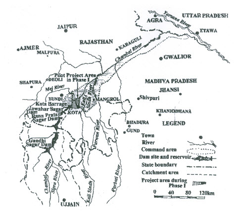
Fig. 15.1. Location map of Chambal Canal Command Area, Rajasthan. (Source: UNDP, 1971)
The quality of water in the canals is good. The climate of the project area is sub-tropical and semi-arid. The average annual rainfall is 850 mm and has substantial inter-year and spatial variation. About 90 per cent of annual rainfall is received during the monsoon period (July to September). The summer temperature occasionally rises to as high as 49°C during May-June and the winter temperature falls to as low as 4°C during December-January. The mean annual potential evaporation is 2650 mm, far exceeding the mean annual rainfall.
The elevation of the command area ranges from 170 m to 260 m above mean sea level. The irrigated land is flat with an average slope of 0.08%. There are several rivers and meandering streams (nallas) passing through the area. The Chambal river runs in the centre of the command area, with three major perennial rivers, namely the Maj, the Kalisindh and the Parbati, joining it. Also, there are some smaller perennial rivers and numerous non-perennial tributaries in the Chambal river system. Deep alluvial to exposed or thinly covered shale, limestone and sandstone comprise the main geologic formations of the command area. Further details of the Chambal Command Area can be found in Bhattacharya and Michael (2003).
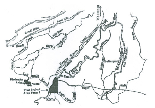
Fig. 15.2. Layout map of Chambal Command Area, Rajasthan. (Source: Anonymous, 1995)
15.3.2 Genesis of RAJAD Project
Before introducing canal irrigation in the command area in 1960, it was under rain-fed agriculture and there was no significant waterlogging problem then (Mehta, 1958). Soon after canal irrigation started, the groundwater table began to rise and waterlogging and salinity problems occurred. According to the Preparatory Mission Report of FAO (1966), “By 1965, of the 32,000 ha estimated under irrigation about 16,000 ha had water table within 1.5 m bgl and were to varying degrees, affected by salinity.” During the initial phase of irrigation, there was a major gap between the development of irrigation potential and water utilization. With the increase in irrigation development there was rapid rise of water table and salt problems in the command area. By the 1970s about 161,000 ha of land had waterlogging problem (water table within 3 m of the soil surface), and about 25,000 ha were affected by salinity.
Considering the importance of the Chambal Irrigation Project and the magnitude of the problems involved, the Government of India requested for the assistance of the United Nations Development Programme (UNDP). The UN assisted project: “Land and Water Use Management in the Chambal Command Area, Rajasthan” became operational in March 1968 (UNDP, 1971). Besides UNDP, the Governments of Rajasthan and India and the FAO of the United Nations were also involved in the project. The project envisaged evolving solutions to the soil and water management problems in the irrigated area by implementing a pilot development scheme in the Rajasthan part of the canal command area. The drainage related objectives were: (a) control of waterlogging and salinity, (b) proper distribution of the irrigation water and control of weeds in canals, and (c) improvement in irrigation, drainage and farm practices in the farmers’ fields. By the end of 1970, a land development system evolved. It was named On-Farm Development (OFD). This was subsequently supported by the World Bank. Some of the components of the OFD programme were realignment of the field boundaries to facilitate proper layout of irrigation, drainage and road systems, land shaping for efficient irrigation water distribution and better surface drainage, and construction of irrigation and drainage channels with necessary structures to serve each farm.
The watershed concept was adopted for the OFD work. A typical sub-watershed size was between 1000 and 10,000 ha of irrigated area. Field drains (lateral drains) at about 500 m apart either joined a sub-main, or depending on the topography and main drain layout, were directly connected to the main drain. Interceptor drains were provided adjacent to the canals to arrest the seepage flow before it could cause waterlogging and salinity problems in the adjoining area. Fig. 15.3 shows a sketch of the irrigation and surface drainage systems.
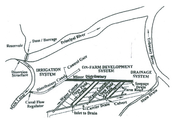
Fig. 15.3. Schematic sketch illustrating on-farm development system (OFD) in Chambal Canal Command Area, Rajasthan. (Source: Anonymous, 1995)
Based on the initial success of the watershed based OFD works in the irrigated areas, a Command Area Integrated Development Programme was launched as a follow up by the World Bank and the Government of India. Under this programme, surface drainage works in 167,000 ha and OFD works in 55,000 ha were completed during 1977-1990.
Although a surface drainage network was developed in the Chambal Command Area, its poor maintenance caused serious problems of waterlogging, soil salinity and silting of many of the drains (Figs. 15.4 and 15.5). It became evident that subsurface drainage was essential to reclaim saline and waterlogged lands and also to prevent further development of salinity and waterlogging. The Rajasthan Agricultural Drainage Research Project (RAJAD Project) took up subsurface drainage work on a relatively much larger scale than elsewhere in India. Under this project, the earlier executed surface drainage network was also renovated and used for gravity flow of subsurface drained water into and through them.

Fig. 15.4. A view of surface water standing in a crop field in the Left Main Canal Command Area, Chambal Project, Rajasthan. (Source: Anonymous, 1995)
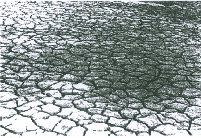
Fig. 15.5. Salinity affected cracked soil surface in a test plot in the Left Main Canal Command Area, Chambal Project, Rajasthan. (Source: Anonymous, 1995)
15.3.3 Introduction to RAJAD Project
On farm irrigation efficiencies and surface drainage improved substantially in the Chambal Canal Command area through the various developmental activities undertaken during the Phase-I and Phase-II projects. However, salinity and waterlogging problems continued to exist. Towards finding a comprehensive solution to these problems, the Rajasthan Agricultural Drainage Research Project (RAJAD) was started in 1991, initially for a 7-years period. It was undertaken jointly by the Governments of India, the State of Rajasthan and Canada. The main focus of the project was on establishing horizontal gravity based subsurface drainage system in a target area of about 20,000 ha area, preceded by a pilot research project in about 10 percent of the target area to determine various parameters of the design to be followed for the larger area. The objectives of the project were to reclaim saline and waterlogged irrigated lands, to prevent development of salinity and waterlogging, and to improve agricultural productivity of the farmers of the Chambal Command Area. The project had utilized some of the surface drainage infrastructure built earlier under the UNDP programme of OFD after making suitable renovations. It was a large-scale applied research project focusing on the design and execution of horizontal subsurface drainage system and adopting complementary land and water management measures for waterlogging and salinity control and for enhancing the agricultural production in irrigated agricultural lands in the semi-arid region. The commissioning of the subsurface drainage systems and construction/renovation of outlet drains and structures were completed by 2000. Presently, the executed system is monitored by the Chambal Command Area Development Authority.
For the first few initial years, the RAJAD project made an in-depth study of drainage and irrigation water management in the Chambal Command area and the following findings were obtained:
Heavy soil with poor internal drainage, seepage from the irrigation canals, excessive irrigation and a lack of properly functional drainage system due to weed growth and sloughing of the banks were the major causes of waterlogging and salinity in the command area.
Deterioration of the canal infrastructure constructed in early 1960s had been so widespread that there rehabilitation would be expensive and even if done, it might not help in solving the problem.
The existing irrigation practices are wasteful, and hence they need to be improved.
Surface drains constructed during the OFD works were unable to control waterlogging due to lack of maintenance and unauthorised construction of checks across the drains.
Despite the existence and operation of several thousands shallow tube wells in the Chambal Command area, the concept of conjunctive use of surface and groundwater for controlling the rise of water table did not materialise.
Considering the alarming spread of waterlogging and salinity, horizontal subsurface drainage, supplemented by land shaping and surface drainage appeared to be the best alternative for enhancing and sustaining soil health and agricultural productivity in the command area.
Out of the 285,000 ha Rajasthan portion of the Chambal Command area, with several saline and waterlogged patches, the RAJAD project area was selected based on a careful data collection and analysis of the type and severity of the problem, suitability of the subsurface drainage technology as a major remedial measure and the site feasibility of adopting a gravity flow based subsurface drainage system.
15.3.4 Pilot Studies in RAJAD Project
Before taking up the large scale subsurface drainage installation, a number of smaller representative areas, 50 to 180 ha in size were identified to conduct pilot experiments in order to develop design criteria and identify suitable installation technology. The total pilot experimental area was 1400 ha distributed in ten locations. The results of the pilot study were monitored in terms of the effect of drain depth and spacing on water table decline salt removal, drain discharge, traficability and crop production. In addition, the other post-pilot investigations and monitoring were sediment outflow through the drainage effluent and consequent decision on the filter type and quality, impact of subsurface drainage water disposal in the open drainage system in changing the water quality and its environmental implications, changes in soil physical properties due to the functioning of subsurface drainage technology.
The important findings and conclusions from the pilot studies in the ten research areas under the RAJAD project are as follows:
Saturated hydraulic conductivity calculated from drain discharge versus hydraulic head data varied from 0.25 to 0.55 m/day in the top 1 metre depth; 0.02 to 0.2 m/day in the 1 to 1.5 m depth and 0.75 m/day below 1.5 m depth. The drainable porosity varied from 2 to 5%.
The transient drainage design equation of Glover-Dumm was found appropriate than the steady-state equation of Hooghoudt.
A crop tolerance period of 3 days was found acceptable for drainage design.
A drainage coefficient of 1 to 4 mm/day or a water table decline of 20 to 40 cm below the ground level within 3 to 4 days (later standardized to 20 cm in three days) were found adequate for water table control and salt leaching.
An average drain depth of 1.2 m, with a range from 1 to 1.5 m was found adoptable considering the gravity drainage requirement and flat land.
Drain spacing of 30 m was found necessary for the control of salinity and waterlogging, whereas it was 60 m for the control of salinity only.
Synthetic filter was found to be suitable for large scale subsurface drainage installation work.
Performance analysis of the pilot study indicated an anticipated average Benefit-Cost (B-C) ratio of 2.4 for the subsurface drainage technology.
The results from all the pilot study sites were synthesized for undertaking the subsurface drainage work in the remaining area of the RAJAD project. Different drainage machinery, filter types (without filter as well) drain depth and spacing and layouts were used, and adopted to complete the installation by the year 2000. The installation programme included providing suitable structures, outlets, deepening and re-sectioning of the existing open drain network, providing new open drains and some other constructional activities. Presently, Chambal Canal Command Area Development Authority is maintaining the executed system.
15.3.5 Irrigated Water Management Pilot Projects
Since, drainage is an important but just one of the several requirements for efficient water management to reclaim land and enhance agricultural productivity. Therefore, the concept of Integrated Water Management (IWM) was introduced in RAJAD as a pilot programme in 1994. Due to the multidisciplinary input requirement towards achieving the desired goal through IWM, there has been an effort to ensure effective cooperation and involvement of various agencies working on the problem of land and water management in the Chambal Command area to ensure their effective and complementary functioning towards the common goal of increasing agricultural production per unit of land and water.
The IWM program had the following specific objectives:
(i) Adopt a multidisciplinary approach in irrigation management.
(ii) Ensure effectiveness of water supply to the fields and improved water application efficiency.
(iii) Establish pilot-scale demonstrations of effective water delivery and control systems.
(iv) Ensure adequate and timely supply of crop production inputs.
(v) Assist in the introduction of rotational water delivery in selected blocks.
(vi) Improve farmers’ awareness and ensure their participation through Water User’s Associations (WUAs).
The IWM pilot project, with the above objectives was introduced in three blocks, IWM-1, IWM-2 and IWM-3, all of which were served by the Chitawa distributary on the LMC of the Chambal canal system. The block IWM-1 with an area of 22 ha was non-saline and without subsurface drainage, had clay loam soil and grew soybean and paddy in the kharif season and wheat mustard and berseem in the rabi season. The block IWM-2 with an area of 40 ha was saline and having subsurface drainage, had clay to clay loam soil and with similar cropping pattern as of IWM-1. The block IWM-3 with an area of 19 ha had highly saline and uncultivable patches, sandy loam soil and was proposed to be equipped with a subsurface drainage system under the pilot project (Gaur et al., 1996).
Baseline surveys on socio-economic status of the farmers of the IWM blocks as well as on the cropping system followed were conducted. Major constraints in the irrigation supply system, water application methods, drainage system, agronomic practices and information dissemination in the IWM blocks were identified. Also, necessary field investigations were conducted in all the three IWM blocks in order to minimize water and fertilizer losses. WUAs were also formed and trained for their active participation in local water management activities.
15.3.6 Concluding Remarks
Proper planning and implementation of the command area development program in the Chambal Command Area of Rajasthan, in different phases could combat satisfactorily the severe problems of waterlogging and salinity. The programme comprised lining of canal water conveyance and distribution system, land levelling, provision of drainage disposal network, on-farm surface drainage and subsurface drainage in selected areas and provision of access roads to farms. The development and adoption of suitable cropping patterns and crop management practices formed an important activity. Appropriate models for the effective maintenance of irrigation and drainage systems could be established in the IWM blocks and some other locations. However, the comparatively slow pace of development is directly attributed to the lack of direct involvement of the farmers in the development project and farmers’ participation in the extension training programmes. There is a need for active participation of the farmers in these areas. The farmers could be helped, advised and educated on modern and efficient land and water management methods through WUAs.
The RAJAD project has been able to develop valuable information on various water management and essential complementary practices such as irrigation, drainage, land development, suitable cropping system and crop husbandry and farmers’ participation. The multi-disciplinary approach to combat the problem and the involvement of various agencies at the State and the Central Government levels, including the State Agricultural University, the Central Soil Salinity Research Institute and the substantial involvement and support of international agencies like the UNDP, World Bank and Canadian International Development Agency have been commendable. Now, there is a need to extend the benefits of the technology to the entire command area and other major and medium irrigation projects with comparable agro-climatic and socio-economic situations. There is also a need to continuously monitor the performance of irrigation and drainage systems in an irrigation command area. Appropriate and timely actions are essential to prevent the occurrence of waterlogging and salinity problems as well as to find suitable remedial measures for their control in case these problems occur.
15.4 Pilot Projects on Land Reclamation and Management of Salt-Affected Soils in Haryana
15.4.1 Overview of Project Area
The state of Haryana is situated between 27°35¢ to 31°55¢ 30² N latitude and 74° 22¢ 48² and 77° 35¢ 36² E longitude. The south-western boundary of the state merges with the Thar desert. It is an agriculturally advanced state in the Indo-Gangetic plain and is an important segment of the rice-wheat belt in India. The state is characterized by a sub-tropical semi-arid climate with a relatively short but distinct monsoon season of about three months (July to September), receiving about 83% of the annual rainfall. Most of the remaining part of the year experiences a dry climate with high evaporation rates. The average annual rainfall varies from 800 mm in the north to 300 mm in the west. Maximum temperature of 41°C is recorded in the months of May-June and the minimum temperature of 5°C is recorded during December-January.
There are two river basins, namely, the Yamuna basin (16,330 km2) and the Ghaggar basin (10,675 km2). There is also an internal basin (17,207 km2), which is physiographically depressed. In the absence of any natural drainage outlet, the internal basin has serious waterlogging and salinity problems. Irrigation water of 1.05 million hectare metres (Mha.m) from the two major canal systems, namely the Western Yamuna and the Bhakra and about 0.85 Mha.m of good-quality groundwater provide irrigation to about 1.2 Mha land in the state.
15.4.2 Need for Salt Management and Initiation of Pilot Projects
Haryana state has been facing serious problems of waterlogging, soil salinity and alkali condition. Significant rise in water table has occurred in a major part of its arable irrigated. Groundwaters in the regions of rising water table are generally brackish. About 77% of the area of the Yamuna and the internal depressed basins has brackish groundwater. Due to semi-arid climate, salt accumulate in the shallow depths, arising out of evaporation from shallow and brackish groundwater table. Additionally, considerable salt is also added to the irrigated lands by the irrigation water delivered by the canal system. Non-exploitation of the saline groundwater and recharge from the canal irrigated area have aggravated the water table rise and groundwater salinity problems in these two basin areas (Figs. 15.6 and 15.7).
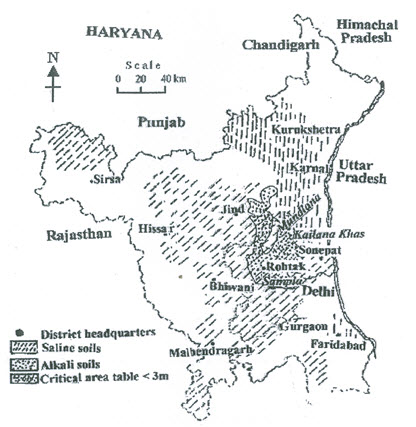
Fig. 15.6. Distribution of saline and alkali soils in Haryana and the location of pilot projects on the reclamation of saline soils undertaken by CSSRI under the Operational Research Project Scheme. (Source: Rao et al., 1986)

Fig. 15.7. Extensive saline barren land in the Pilot Project area of CSSRI in Haryana, prior to reclamation. (Source: Bhattacharya and Michael, 2003)
The Indian Council of Agricultural Research (ICAR) had established the Central Soil Salinity Research Institute (CSSRI) in 1969 at Karnal township in the Karnal district in Haryana. After about five years of research, the institute developed some tentative technologies for the reclamation of salt affected soils. In 1974, the ICAR sanctioned an operational research project (ORP) to the CSSRI for the reclamation of alkali soils of the Karnal district. This project had the following objectives: (i) to test and demonstrate available technologies of alkali soil reclamation to make such lands productive, (ii) to promote technology transfer, (iii) to monitor changes in the soil properties after adopting reclamation measures, (iv) to study the economic implications of the adoption of reclamation measures, and (v) to improve the standard of living of the farming community. Subsequently in 1979, the institute started pilot projects for reclaiming waterlogged saline lands with identical concepts as in the earlier ORP. Initially, the pilot projects were established in selected problem areas in Haryana state. Later, similar projects were undertaken by the institute in other states facing similar problems of waterlogging, soil salinity and alkali. The two case studies reported in subsequent sub-sections are based on the pilot projects undertaken by the CSSRI, Haryana.
15.4.3 Case Study on the Reclamation of Saline Soils of Sampla Experimental Farm
(1) Introduction
The pilot project on reclamation of saline soil was the first major project of its type and was taken up in the Panchayet (a village Panchayet is a local body elected by the villagers) land in the village Sampla in Rohtak district of the Haryana state (Gupta et al., 1998). The project area is located in the Western Yamuna Canal Command Area and is a part of the depressed internal basin, which has no natural outlet even for surface drainage. Hence, runoff water disposal is through a pump drainage scheme of 1.5 m3/s capacity. The pumped water is led to an irrigation distributary (Dulehra) of 10 m3/s capacity. The project site is around the central region of the basin with a bi-directional slope of 0.2% along south-west to north-east direction and 0.1% from west to east.
The initial small-scale experiment on open drains spaced 25 m apart and buried subsurface drains spaced 50 m apart were operated successfully, but the latter drainage technique was suggested as the more acceptable solution for large-scale saline land reclamation work because of several reasons such as the loss of area, frequent maintenance, and incompatibility with mechanized farming in the case of open drains.
(2) Characteristics of the Pilot Project Area
The area is characterized by 650 mm average annual rainfall and 2000 mm annual evapotranspiration. The water table fluctuates from surface in the monsoon season to 1.8 m below the surface in the summer season. The soil texture is sandy loam in 0 - 1.8 m depth; sand to loamy sand for a variable depth of 0.7 to 1.7 m thereafter and sandy loam again beyond that at depths varying from 2.5 to 3.5 m and down below. This layer being located below a relatively more previous layer, it was treated as the impervious layer for drainage design purpose. The saturated hydraulic conductivity at the upper 1.1 m soil was 1.15 m/day, for the soil layer from 1.1 to 1.8 m it was 0.85 m/day and from 1.8 to 3 m, it was 7.5 m/day. The bulk density of the 0-20 cm surface soils was unusually high (1.67 to1.83 g/cm3). Steady-state infiltration rate was low (4.8 cm/day). The soil salinity in the 0-15 cm soil layer had a high spatial variability (20 to 150 dS/m). It varied from 50 to 75 dS/m in the 15-30 cm soil layer and remained fairly constant at 30 dS/m at deeper depths. The high soil salinity at or near the surface was caused by high evaporation from the shallow water table of poor quality. Temporally, the salinity was higher during the period from January to June.
(3) Design of Subsurface Drainage System
For designing a drainage system, the first requirement was to find the drain depth. Due to the need of leaching of salts and avoid salinization due to capillary rise in the compacted surface soil layers, the drain depth was kept at an average of 1.75 m from the ground surface. With a hydraulic head of 50 cm, this would restrict the water table to a depth of 1.25 m from the ground surface. The relatively course sandy loam soil (except the top 20 cm, where the soil was compact) would restrict upward capillary movement of water. The water table depth of 1.25 m was considered adequate for growing pearl millet and sorghum in the monsoon season. Having decided on the depth, based on the specific crop requirement and soil features, the lateral drain spacing was determined using Ernst equation. The calculated drain spacing was 50 m. As the pilot project was to develop suitable drainage design criteria applicable in similar conditions elsewhere, and all drainage design equations are based on certain assumptions, which are only partially valid in the field, two other spacings were adopted. One was 50 per cent higher and the other was 50 per cent lower than the drain spacing calculated by Ernst equation. Mineral envelop was used around the lateral drains to a thickness of 7.5 cm. The envelope was needed as the soil had more than 70% of fine sand. The drain envelope was designed based on the study by Kamra and Rao (1984). River bed material was sieved to get the envelope according to the design. The lateral drains were made of 30 cm long cement concrete pipes with straight edges placed end to end. The collector drains were made of 2 m long straight edged reinforced cement concrete pipes with collar joints. The trench for laying the drain pipes had a trapezoidal shape from surface down to 1.5 m and a narrow 30 cm ´ 30 cm section below to reduce the earthwork and also to reduce the unnecessary spread and waste of envelope material. The drain slope closely followed the topography to avoid the drains being too shallow or too deep at places with respect to the local ground level. The system was commissioned in the summer of 1984 when the water table was at the lowest level during the year. The complete design information of the subsurface drainage system is summarized in Table 15.1.
Table 15.1. Specifications of the subsurface drainage system at the Sampla pilot experimental farm (Source: Gupta et al., 1998)
|
Sl. No. |
Particulars |
Design Description |
|
1 |
Lateral drain depth |
1.75 m |
|
2 |
Lateral drain spacing |
25, 50, 75 m |
|
3 |
Lateral drain slope |
0.2% |
|
4 |
Collector drain slope |
0.1% |
|
5 |
Maximum lateral drain length |
300 m |
|
6 |
Lateral drain diameter |
10 m |
|
7 |
Collector drain diameter |
20 cm |
|
8 |
Material of lateral and collector drains |
Cement concrete |
|
9 |
Type of envelope |
Mineral |
|
10 |
Type of outlet |
Pumped |
The drainage system was installed manually in a 10 ha area initially, which was later extended to another 40 ha to test other design alternatives in terms of depth and spacing of the drains and drainage material (Fig. 15.8).
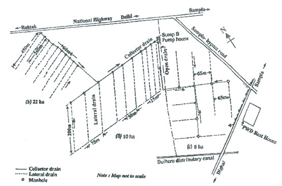
Fig. 15.8. Layout of subsurface drainage experimental system at the Sampla Drainage Experimental Station, Rohtak district, Haryana. (Source: Anonymous, 1998)
Observation wells were provided at a regular interval in the drained area to monitor hydraulic head distribution and inspection chambers were provided at the end of the lateral drains to allow sampling of the drainage effluent for laboratory analysis. In absence of a gravity outlet, a large diameter and deep sump well was constructed to have sufficient storage capacity for the drainage effluent, which was pumped out and into a shallow surface drain from where, the water could be pumped into the Dulhera distributary (Fig. 15.9). An alternative arrangement was also made to dispose the drainage effluent by constructing an evaporation pond to collect the drainage effluent, when for some reason; the distributary cannot be used for effluent disposal. Commissioning of the drainage system was followed up by crop cultivation on land by adopting all the scientific methods of crop husbandry, and irrigation water and fertilizer management practices.
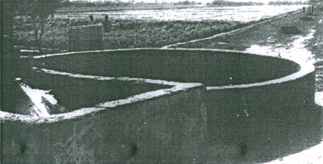
Fig. 15.9. Fifth year of reclamation of Sampla Experimental Farm, Rohtak district, Haryana. Note the subsurface drainage water discharges into a small tank, the sump well and the rich crop land of the project area in the background. (Source: Bhattacharya and Michael, 2003)
(4) Evaluation of Drainage System
Drainage system was evaluated by monitoring the rate of drainage effluent flow, its quality and crop yield. From the base level of no crop production prior to reclamation, the average yield of wheat over 10 years of the post-reclamation period was 4.5 tones/ha in the project area. During the monsoon season, the drain discharges were equivalent to the drainage coefficients varying between 1.7 to 8.1 mm/day. However, during the winter season, when the source of water was only irrigation, there was a decline in drain discharges.
The monitored water quality parameters for drainage effluent, groundwater and canal water were electrical conductivity (EC), concentrations of sodium, calcium, magnesium, bicarbonate and chloride, and the sodium adsorption ratio (SAR). The canal water quality was found to be the best with EC of 0.7 dS/m; SAR of 0.8 (meq/L)1/2; and (calcium + magnesium), sodium, bicarbonate and chloride concentrations respectively as 2, 0.8, 2 and 0.8 meq/L. The quality of groundwater (sampled from 20 m depth) was the poorest with EC as high as 32.5 dS/m and high values of all the other constituents. The drainage effluent properties were in between the properties of the canal water and the groundwater, with all the parameter values gradually reducing over the years. Although the SAR of the drainage effluent was reducing over the years, it was always higher than that of the groundwater.
(5) Lessons from Sampla Pilot Experiment on Saline Land Reclamation
The sample pilot experiment indicated that the practice of only land drainage for saline land reclamation is not enough; rather it should be one component of a package of practices for crop production. Such a package should consist of land grading and shaping, field dyking (for impounding water for a comprehensive leaching of salts), surface drainage system selection of suitable crops and cropping sequences, and adoption of improved cultural practices, together with the subsurface drainage system (especially for removing the concentrated water from the soil).
According to the Sampla experience, the crops (and their salt tolerant varieties) that may well adapt themselves to the condition at the initial years of reclamation (subject to availability of irrigation water) are paddy, barley, wheat, mustard, cotton, sorghum, cluster bean and pearl millet. As to the cultural practices, it was experienced that a 25% more seed rate for the seeded crops and 25% more plants per unit area for transplanted crops, as compared to the seed rate and transplanting density in normal (non-salient) soils would provide desired plant population in saline soils at the initial period of reclamation. This is needed to compensate for the mortality of seedings and poor tillering in saline soils. Crops grown in saline soils respond well to the added doses of Nitrogen and Phosphorus fertilizers over the doses in normal soils. Application of Farm Yard Manure (FYM) with Phosphorous reduces salt injury to the plants. The generally high quantity presence of Potassium in saline soil gets depleted under excessive leaching during reclamation, in which case, Potassium fertilizer should also be added in quantity decided on the soil test result. Soils with shallow water table are prone to salinisation if left fallow, particularly during dry period. Subsurface drainage reduces soil water salinity and under shallow water table condition, plants are able to uptake this water thereby reducing irrigation requirement. In the Sample experiment, plant uptake of groundwater with salinity between 3 to 5.5 dS/m could reduce surface irrigation water application by 50%, still achieving good crop yield comparable to normal conditions. Subsurface drains reduced salinization considerably and whatever salts accumulated at or near the soil surface those were leached or washed out during the monsoon season.
Finally, to manage drainage effluent, it was found that it is possible to blend the drainage effluent with other available water of good quality and still get a salinity of the blended water which is within the permissible limit of irrigation water quality for a given soil, water table depth and crop conditions. The Sample experiment revealed that for wheat, after giving a pre-sowing irrigation with canal water of EC 0.5 dS/m, subsequent irrigations using blended water with an EC range of 6 to 12 dS/m gave 97 to 83% yields, respectively as compared to the yield obtained by canal water irrigation alone. On the other hand, irrigation of mustered with blended water of EC 8 dS/m gave higher yield compared to the yields obtained by irrigation with canal water and blended water of EC 15 dS/m (Sharma et al., 1995). This study also revealed that cyclic use of canal and blended water was possible.
In the reclamation of saline land, there are two essential steps. Firstly, leaching of salts to reduce the soil salinity to a level that is not harmful to the crops to be grown. Secondly, following scientific land, water and crop management practices to sustain the beneficial effect of salt removal by leaching. As the package of practices are formulated based on the relevant data collected from a site, the specific details of the salt management technology of a region may not be directly applicable to other regions.
15.4.4 Case Studies on Alkali Land Reclamation
(1) Overview of Project Area
Alkali lands are found over large regions in the state of Haryana. Under the earlier mentioned Operational Research Project (ORP) of CSSRI, Karnal (Haryana), developing methodologies for alkali land reclamation was a main mandate. Pilot projects on alkali land reclamation were initiated in the mid 1970s in two clusters of seven villages, where the alkali problem was acute in large areas (Fig. 15.10).
There were four villages namely Kachhwa, Sagga, Sambhi and Birnaraina in the first cluster with a total area of about 6000 ha which about 1952 ha (32.5%) area were suffering from alkalisation problem. The second cluster consisted of three villages namely, Gudda, Begampur and Dadlana with a total area of 2500 ha of which, 500 ha (20%) affected with alkali problem (Bhattacharya and Michael, 2003). Important common soil topography and hydrometeorologic feature of these villages are described below.
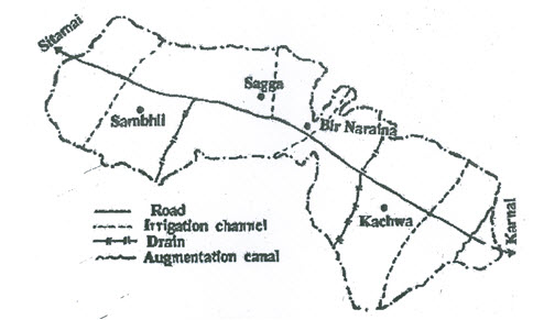
Fig. 15.10. Location of the first cluster of villages along the Karnal-Sitamai road lying between 6 and 26 km from Karnal in which the Pilot Projects on the reclamation of alkali soils were understand by the CSSRI, commencing in 1975. (Source: Mehta and Mondal, 1988)
The alkali-affected areas were distributed over several patches, large and small, interspersed with normal soil regions. The pH of the surface soils was high (10.1). It was only marginally lower below the surface with a slightly reducing trend with increasing depth within the root zone (Bhattacharya and Michael, 2003). Besides high pH, the alkali soils had dominant cation Sodium and the dominant anions of Carbonates and Bi-Carbonates of Sodium. There were concretions at the root zone and below it. The salinity was also high (ECe of the surface soils being 8 dS/m), going down with depth to 4.8 dS/m at 90 cm below the soil surface. The soil texture is sandy loam, with clay content varying from 16 to 27%. The infiltration rate was very low at 3 mm/day. Crop activity was practically non-existent in the alkali lands (Figs. 15.11 and 15.12). Even rice could not grow well due to the presence of high Sodium in the soil with an ESP of 62 to 95%. The 12-year (1975 to 1986) average annual rainfall recorded at the CSSRI observatory, located close to the project site, was 730 mm.
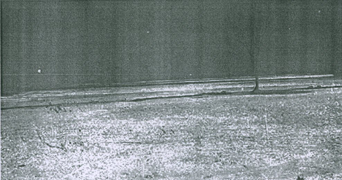
Fig. 15.11. A view of an extensive area of alkali land in the CSSRI Pilot Project area prior to reclamation. (Source: Bhattacharya and Michael, 2003)
Long dry spells in the monsoon season were quite common and a major part of the monsoon rainfall was received in a few storms in some of the years. Due to poor infiltration, most of the runoff water was going waste and causing soil erosion, whereas the remaining water was stagnating on the land for long durations. The water table fluctuation ranged from 2 to 3 m. The water quality of a few tubewells was good with EC of 0.6 dS/m and was free from Sodium hazard. The annual pan evaporation was about 1640 mm.

Fig. 15.12. An extensive stretch of alkali land in the Pilot Project area of CSSRI in Haryana prior to reclamation. Source: Bhattacharya and Michael, 2003)
(2) Project Activities
The operational research projects were taken up with full participation of the Institute (CSSRI), the village body, the district administration and the farmers. In addition, collaboration of the Haryana Land Development Corporation and financial institutions ensured timely supply of the necessary inputs such as gypsum and fertilizer, and completion of activities of land levelling and installation of tubewells for the farmers.
Land Levelling and Bunding: Land levelling suited to the desired irrigation and drainage and bunding for the leaching of Sodium by rainfall or applied water, after converting Sodium Bicarbonate and Carbonate into Sodium Sulphate form by applying Calcium Sulphate (gypsum), are the two important field constructional activities for the reclamation of the alkali lands. The bunded fields when reclaimed from the alkali problem are suitable for rice cultivation. The alkali lands in the project area were levelled using a scraper, giving a gentle slope of 0.1%. Strong bunds of 35 to 40 cm height were constructed surrounding large areas, which were subdivided into 0.4 ha blocks by constructing smaller bunds around them.
Irrigation and Drainage: Shallow tubewells were constructed for irrigation and for meeting leaching requirement. Groundwater pumping also helped in lowering the water table. The discharge of a 10 cm diameter tubewell was about 10 Lps, which could irrigate 4 to 5 ha of land. For the bunded rice fields, the need of surface drainage was considerably reduced, but not completely eliminated due to the occurrence of a few heavy rains in the monsoon season. In the initial stages of reclamation of alkali lands, subsurface drainage did not work due to sealing of the pores of surface soil by the dispersed clay particles and poor water transmission characteristics through the soil below the surface. This is why, groundwater pumping was adopted for irrigation and for controlling water table, and surface drainage for evacuating excess rainfall in some of the ORP villages.
Application of Amendment: The most commonly used amendment for the reclamation of alkali soils is gypsum. In the ORP villages, the pH of the surface soils varied from 9.8 to 10.6. Gypsum powder was applied to the ploughed and levelled land at a rate of 12.5 tonnes/ha and mixed with the topsoil using a plough. It was applied 15 to 20 days before paddy transplantation in June-July so as to take advantage of the monsoon rainfall in dissolving gypsum and percolating the solution down the soil profile. Addition of gypsum displaced Sodium from the exchange complex by Calcium, which improved the soil permeability thereby facilitating natural leaching of Sodium Sulphate (a reaction product).
Cropping Pattern: During the initial phase of reclamation for a few years rice varieties IR-8 and Jaya were grown. Later fine and super-fine varieties such as PR-106, PR-107, Basmati (B-370), Pb. No. 1, Basmata, CSR-1, CSR-27, Pusa 150 and Pusa 169, were tested and popularised because they provided more economic returns. Where well irrigation water was available, green manuring crop was grown prior to initiating paddy cultivation. Nitrogen was applied at a rate of 150 kg/ha in four equal splits (one essentially at the time of transplanting) and Zinc Sulphate was applied at a rate of 25 kg/ha. Neither Phosphorus nor Potassium was necessary for first 4-5 years of cropping after starting the reclamation by the conjunctive use of amendment and leaching. After harvesting the kharif paddy during the first week of October, the land was ploughed and allowed to dry for about a week for the cultivation of rabi crops. Normal (HD 2009, WH 711, HD 1982, KRL 19) or late (HD 1553) varieties of wheat were selected depending on the time when a favourable sowing condition arrived. Nitrogen was applied at a rate of 130-135 kg/ha with 50% as the basal dose and 25% each at tillering and pre-flowering stages. Five to six irrigations were given to wheat; the first irrigation was given four weeks after sowing.
Though the most common winter crop of the region was wheat, berseem (Trifolium alexandrinum) and shaftal (Trifolium resumpinatum) were also grown to meet the requirement of the farmers. In addition, different trees were grown after reclaiming alkali soils.
Tree Plantation in the Reclaimed Land: Different trees were planted on alkali soils after reclamation and growing crops for a limited period. A new approach for tree plantation was evolved which aimed at solubilization of native calcium carbonate for the reclamation of alkali soil and providing suitable soil condition for the growth of roots. (Figs. 15.13 to 15.15). It led to a large-scale and successful plantation of useful trees with intercrops.
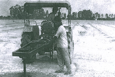
Fig. 15.13. Drilling of hole with a mechanically operated auger to break the hard layer formed by kankar layer about 1 m below the land surface in the CSSRI Pilot Project area for tree plantation. (Source: Bhattacharya and Michael, 2003)
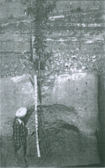
Fig. 15.14. Soil profile showing the root development of a one-year old eucalyptus sapling planted using a mechanically operated soil auger. (Source: Bhattacharya and Michael, 2003)
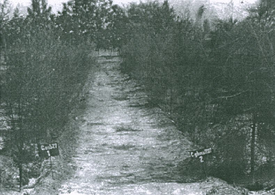
Fig. 15.15. Afforestation of the salt-affected area. Trees are planted in the irrigation furrows. Note the salt accumulation on either side of the rows of trees. (Source: Bhattacharya and Michael, 2003)
(3) Lessons from Pilot Experiments on Alkali Land Reclamation
Need for Technology Demonstration: During 1975-1986, small demonstration plots measuring 0.2 to 0.4 ha were set up in some of the worst alkali affected farmers lands. The total number of such demonstration was more than 600 in the seven ORP villages. These demonstrations served as the eye-openers for the alkali affected cultivators by convincing them that their bad and unproductive/less productive lands can be made productive with remunerative crop yields by applying amendments and by following simple cultural practices.
Farmers’ Participation: Through the initial demonstration of the techniques of alkali land reclamation, the farmers’ participation in learning and applying the technology could be ensured. This was the most important factor, which was responsible for reclaiming almost the entire alkali land of the affected villages by the initiative, effort and input of the farmers themselves. Out of the total alkali affected are of about 2500 ha in the seven ORP villages, about 160 ha was reclaimed under the demonstration program and the farmers themselves reclaimed an additional alkali land of 2200 ha at their own costs. The increase in grain yields of about 1 tonne/ha from the demonstration plots compared to the farmers’ fields were considerably reduced when the farmers mastered the art of the technology application and followed desirable cultural practices.
Cultural Practices: Besides the reclamation technology a suitable package of cultural practices are required to be followed in the alkali lands during and after reclamation. The package comprises proper water management, weed management, green manuring, application of FYM, fertilization through mineral fertilizers (mainly Nitrogen), maintaining timelines in field activities and the use of good quality seeds. In the reclaimed alkali land, crop diversification is possible within and outside the rice-wheat rotation. In the ORP villages, these were fodder sorghum, mustard, green gram and vegetables such as onion, garlic, radish, potato, tomato, brinjal and spinach. Alkali tolerant varieties (if available) should be used in under-reclamation and fully reclaimed alkali lands to take care of the eventual re-alkalinised soil with gradual calcium uptake by the plants.
Alternative Amendment: Besides gypsum, there are other agents for reclaiming alkali lands such as pyrites (iron ore containing Sulphur) and rice husk, available as a by-product from rice mills. In a small scale in the ORP villages, application of pyrite with 15% Sulphur content at a rate of 14.2 tonnes/ha could produce significantly increased yields of rice and wheat. Also, in a few small areas of the ORP villages, the application of rice husk at a rate of 30 tonnes/ha, together with gypsum at a rate of 4.2 tonnes/ha produced the same crop yield as was obtained by applying only gypsum at the rate of 12.5 tonnes/ha.
Improvement in Soil Properties: Application of amendment, leaching and cropping activities improved the soil chemical and physical parameters gradually. The pH and EC of the soils at various depths revealed a continuous declining trend.
Infiltration rate increased from 3 mm/day in the unreclaimed soil to 9 mm/day after one year of reclamation and to 25 mm/day after 5 years. Water holding capacity and hydraulic conductivity of the soil also increased. With increased infiltration and hydraulic conductivity, application of more water became necessary, which proved to be expensive. Therefore, it was recommended to transplant rice seedlings after 2-3 days of gypsum application and impounding water for leaching. This saved water and time, and did not have any adverse effect on the paddy plants. However, this recommendation was not valid if pyrites were used as the amendment.
(4) Concluding Remarks
The pilot project undertaken by the Central Soil Salinity Research Institute yielded useful technologies for the reclamation and management of saline and alkali soils, particularly in the arid and semi-arid regions. The case studies presented in Section 15.4 are based on the two pilot projects in Haryana. Similar projects were subsequently taken up at selected sites within the Haryana state and in some other states such as in Gujarat and Rajasthan. The success of the projects reported under the case studies has been due to the holistic approach to planning, well integrated multi-disciplinary and multi-sectoral involvement, adoption of appropriate technology, and effective participation of the farmers. The technological breakthrough brought about by the projects and ancillary programmes of the Institute attracted global attention and resulted in a significant collaboration and involvement of some international agencies.
Considering the success of earlier irrigation and drainage projects, it is necessary that such efforts should be taken in other parts of the country to solve waterlogging salinity problems, together with the experiences and ideas for avoiding these problems. In addition, the irrigation and drainage technologies are being continuously upgraded and we must take the advantage of the updated and improved global information concerning drainage and reclamation of agricultural lands. Such an approach to land and water management is the need of the hour in order to ensure sustainable agricultural production in the country.
References
Anonymous (1995). Analysis of Subsurface Drainage Design Criteria. Rajasthan Agricultural Drainage Research Project, Chambal Command Area Development, Rajasthan, India.
Anonymous (1998). Subsurface Drainage: A Case Study of the Sampla Drainage Experiment. Indo-Dutch Network Project. CSSRI, Karnal, Haryana.
Bhattacharya, A.K. and Michael, A.M. (2003). Land Drainage: Principles, Methods and Applications. Konark Publishers Pvt. Ltd., New Delhi, India.
FAO (1966). Preparatory Mission Report on the Irrigation Development of the Chambal Command Area in Rajasthan in India. Food and Agriculture Organization of the United Nations, Rome, Italy.
Gaur, A., Verma, B.L., Millete, J.A. and Rana, S. (1996). Integrated Water Management-A New RAJAD Initiation. In: A.M. Shady (Editor), Subsurface Drainage of Irrigated Lands in India, International Commission of Irrigation and Drainage, New Delhi, pp. 8-1 to 8-16.
Gupta, S.K., Sharma, D.P. and Tyagi, N.K. (Editors) (1998). Subsurface Drainage: A Case Study of the Sampla Drainage Experiment. Indo-Dutch Network Project, CSSRI, Karnal, Haryana.
Hooja, R., Srinivas, V. and Sharma, G. (1996). Prevention and remedies for waterlogging problem in parts of Stage-I of IGNP, Rajasthan. In: Technical Papers - Supplementary, National Workshop on Reclamation of Waterlogged, Saline and Alkaline Lands and Prevention thereof, Ministry of Water Resources, New Delhi.
Kamra, S.K. and Rao, K.V.G.K. (1984). Design of gravel envelop around tile drains in sandy loam and loamy sand soils. Journal of Institution of Engineers (India), Vol. 65, AG 1.2.
Mehta, K.K. and Mondal, G.C. (1988). Operational Research on Reclamation of Alkali Soils. Bulletin No. 12. CSSRI, Karnal, Haryana.
Mehta, K.M. (1958). Report of Soil and Crops Investigation Survey, Chambal Command Area, Rajasthan. Agric. Chem. Section, Dept. of Agriculture, Udaipur, Rajasthan.
Michael, A.M., Khepar, S.D. and Sondhi, S.K. (2008). Water Well and Pump Engineering. Second Edition, Tata McGraw-Hill Publishing Co. Ltd., New Delhi.
Rao Babu, P. and Prasad Srinivas, P. (1998). Waterlogging and its management with special reference to Sri Ram Sagar project command area, Andhra Pradesh. In: Technical Papers, National Seminar on Strategy for Prevention and Reclamation of Waterlogged Areas in Irrigation Commands, Ministry of Water Resources, New Delhi.
Rao, K.V.G.K., Singh, O.P., Gupta, R.K., Kamra, S.K., Pandey, R.S., Kumbhare, P.S. and Abrol, I.P. (1986). Drainage Investigations for Salinity Control in Haryana. Bulletin No. 10, CSSRI, Karnal, Haryana.
Sharma, D.P., Rao, K.V.G.K., Singh, K.N. and Kumbhare, P.S. (1995). Recycling of drainage effluent for irrigation. In: K.V.G.K. Rao, M.C. Agarwal, O.P. Singh and R.J. Oosterbaan (Editors), National Seminar Proceedings on Reclamation and Management of Waterlogged Saline Soils, CSSRI, Karnal, Haryana, pp. 189-204.
UNDP (1971). Drainage of Clay Soils. In: Land and Water Use and Management in the Chambal Irrigated Area, Rajasthan, UNDP and FAO of the United Nations, Rome, AGL: SF/IND 60, Technical Report No. 3.
Suggested Readings
Bhattacharya, A.K. and Michael, A.M. (2003). Land Drainage: Principles, Methods and Applications. Konark Publishers Pvt. Ltd., New Delhi, India.
Ritzema (Editor-in-Chief) (1994). Drainage Principles and Applications. International Institute for Land Reclamation and Improvement (ILRI), ILRI Publication 16, Wageningen, The Netherlands.
Schwab, G.O., Fangmeier, D.D., Elliot, W.J. and Frevert, R.K. (2005). Soil and Water Conservation Engineering. Fourth Edition, John Wiley and Sons (Asia) Pte. Ltd., Singapore.
Smedema, L.K. and Rycroft, D.W. (1983). Land Drainage. Batsford Academic and Education Ltd., London.
Last modified: Tuesday, 17 September 2013, 11:04 AM