Site pages
Current course
Participants
General
Module 1 - Water availability and demand and Natio...
Module 2 - Irrigation projects and schemes of India
Module 3 - Concepts and definitions
Module 4 - Command Area Development and Water Mana...
Module 5 - On-Farm-Development works
Module 6 - Water Productivity
Module 7 - Tank & Tube well irrigation
Module 8 - Remote Sensing and GIS in Water Management
Module 9 - Participatory Irrigation Management
Module 10 - Water Pricing & Auditing
LESSON 14. Survey And Investigations For Ofd Works
Introduction
Before the design of the minor and the chaks can be taken up, it is necessary to carry out detailed surveys and investigations. The data so collected has to be analyzed so that the design is appropriate to the field situation.
14.1 Unit for Design:
The smallest unit for design will be a minor serving a group of outlets. This will ensure that the field conditions of the adjoining chaks (command of an outlet) are reflected in the design. If the minor is too large, serving, say, more than 20 outlets, the design can be proposed in two or more parts so that only 10 to 12 outlets are considered at a time. However, to ensure that the adjoining topographical conditions are taken into consideration, in such cases, at least one outlet on each side of the minor should be included in each part of the design so that there is an overlapping area (The design of a chak should not be done in isolation, without consideration of the adjoining chaks). The term 'Chak System' is used to indicate primary unit of design.
14.2 Sill Levels:
After survey, design and construction of distributories and minors, tentative locations and sill levels of the outlets shall be fixed after joint inspection of Construction and CAD organizations. As far as possible outlets shall be located at the upstream of the drops. The sill levels of the outlet shall be taken at or near the bed of the distributory or minor. The locations and the sill levels of the outlets so fixed, will be supplied by the Construction wing to the Command Area Development Authority. The Construction Organization shall also fix stone indicating the sill levels and the locations of the outlets on site. The survey and investigations for a chak system will be taken up after the sill levels of all the proposed outlets in the chak system are provided by the construction organization.
14.3 Farmers:
In canal irrigation, unlike in well irrigation, water that is supplied at the Government outlet is to be shared equitably by all the beneficiary farmers. This involves understanding and cooperation. Therefore, the number of beneficiaries has to be reasonably small. Generally, 10 to 15 beneficiaries can be organized for water sharing. If the number exceeds 20, it becomes practically un-manageable. Therefore, the farmers organization at the outlet will have always to be at the focal point. Suggestions from the farmers organization regarding alignment of F.C., tentative locations of turnouts, requirement and tentative location of graded bunds be sought. Details of the individual holding (pot hissa) in the chak system should be obtained so that the number of farmers under each outlet is known at the time of design. The boundaries of the individual holding should be marked on the village maps.
14.4 Soils:
The soil conditions in a chak affect the design of the water delivery system and land shaping in many ways.
(a) Channel Gradient: Fine Textured soils (Black Cotton Soils) and other clayey soils are easily erodible and hence the gradients of channels in such soils have to be relatively flat. In Coarse Textured (murumy) soils, steeper gradients can be allowed without affecting the stability of the channel bed and depth of water in the channel for diverting water in the field.
(b) Rate of flow: For efficient application of water on the farm the rate of flow has to be controlled according to the character of the soil. Generally in Fine Textured soil (Black Cotton Soils) the rate of flow has to be smaller than in Coarse Textured (murumy) soil.
(c) Land Forming: If the depth of soil is shallow, care has to be taken while designing the land forming work. Some soil cover is necessary even after land forming.
(d) Field Drains: Field drains have not only to carry excess water during irrigation but also to drain the excess run-off during the rainy season. In fine textured soils area, there is likely to be more runoff from rain than in medium and coarse textured soils area. Capacity of the drainage system will have to be varied to suit these variations.
(e) Structures: Design of structures in Fine textured (black cotton) soil is quite different from that in coarse (murumy) soils. The costs also vary accordingly.
The data about soil conditions should therefore be collected and the area in each chak roughly demarcated into different portions as coarse textured or fine textured soil etc. survey number wise, for designing of the water delivery system. The individual farm maps for land shaping should show whether the soils are shallow (less than 22.5 cm), medium (22.5 cm to 45 cm) or deep (45-90 cm) and very deep (more than 90 cm).
For land shaping, data regarding soils is necessary. For this purpose at least five trial pits should be taken, four at the four corners of the farm and one at the centre. The trial pits should have a depth of 1.0 m or should reach coarse-grained soil whichever is earlier. In case of difficulty in taking trial pits, 100 mm diameter auger holes can be taken. Soil samples should be collected at every 0.15 m depth of soil from the top or part thereof and tested for texture. Soil texture refers to the relative proportion of various groups of soils grains in a soil mass. These fractions are called “Soil separates” or “Soil fractions”. The International Soil Science Society (I.S.S.S.) System for soil separates may be adopted as given in Table 14.1 below:
Table – 14.1 Classification of soil separates, I.S.S.S. System
|
S.No. |
Soil Separate |
Diameter Range (mm) |
|
1 |
Coarse sand |
2.00 - 0.20 |
|
2 |
Fine sand |
0.20 - 0.02 |
|
3 |
Silt |
0.02 - 0.002 |
|
4 |
Clay |
Below 0.002 |
The soil texture can be determined by simple field classification methods and the soils are classified in the following 5 broad groups. For many purposes, the complete details of soil textural classes are arranged into groups as shown below:
|
General Soil Textural Group |
Basic Soil Textural Classes |
|
A) Coarse textured soils |
Sandy, loamy sands |
|
B) Moderately coarse textured soils |
Sandy loam |
|
C) Medium textured soils |
Loam ,silt loam ,silt |
|
D) Moderately fine textured soils |
Clay loam ,sandy clay loam, silty clay loam |
|
E) Fine textured soils |
Sandy clay ,silty clay ,clay |
14.5 Field Method of determining soil texture:
Determination of soil texture in the field is made mainly by feeling the soil with fingers and noting the feel as grittiness, stickiness, slipperiness, plasticity, etc. This requires skill and experience. For high accuracy, the texture determined in field by surface feel should be checked against laboratory analysis. The basis of field determination of soil texture by surface feel is explained below:
i) When felt between fingers, the sand particles in soil feel gritty or in case of very sandy samples, these can be seen by naked eye.
ii) The feel of the silt is soft and floury when dry, and is slippery or soapy when moist; but does not stick to the fingers.
iii) The clay when felt between thumb and fingers, is sticky if moist, plastic enough to form a flexible ribbon when pressed.
Thus by means of different feels among the sand, silt and clay, the soil textural class is estimated. However, errors are expected due to presence of organic matter gypsum, calcium carbonate, coarse fragments, soluble salts, etc. The individual textural class can be identified as described below.
Take a handful of soil free from coarse fragments and moist in condition. Rub the soil between thumb and fingers and ask yourself three question, viz.
a) Is the soil gritty?
b) Is the soil silky, slippery and soapy?
d) Is the soil sticky and plastic?
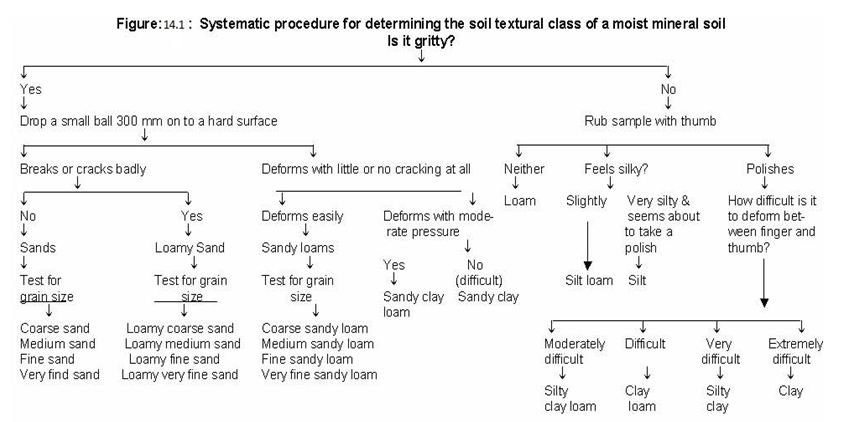
If the soils are equally gritty, silky and sticky, then the soils are ‘loam’ in texture. If in all the feelings, grittiness is more dominant, soils are ‘sandy loam’ in texture. If stickiness is much more dominant as compared to other two feelings, soils are ‘silt loam’ in texture. If stickiness is much more pronounced than grittiness and silkiness, soil is ‘clay loam’ in texture. If it is only silt, silky feeling is present and dominant, whereas other two feelings are almost absent. If the silkiness and stickiness are equally dominant and grittiness absent, then ‘silty clay’ is estimated. If grittiness and stickiness is equally and dominantly felt and slippery feeling absent, the texture is ‘sandy clay’. If loam texture is felt, but sand and clay are felt equally high, it is ‘sandy clay loam’ texture. Similarly in loam texture if both clay and silt are felt dominant the texture is estimated as ‘silty clay loam’. Thus, it is an approximate key to identify soil texture in the field, but should always be supported by laboratory analysis, skill and experience. For ready reference, steps to be followed in field classification are presented in Figure 14.1.
14.6 Other Facilities:
For the given chak system, data about the following should be collected and should form a part of the design report:
(a) Roads
(b) Distance to nearest market
(c) Present area under well irrigation and number of wells
(d) Present area under lift irrigation and bandhara irrigation.
14.7 Crops:
Data of the present crops grown in each chak should be presented in the design report. The data can be obtained from the village records.
14.8 Surveying and Mapping:
Accuracy required for the design of community items is different from that required for the individual items of land forming. Separate surveys are therefore carried out for the two works.
14.8.1 Survey for Community Items:
For design of community items, maps are required in the scale of at least 1:1000 to 1:1250, with contours having an interval of 0.2 m to 0.3 m. Such contour maps can be produced either by Aerial Survey or Ground Survey.
(a) Aerial Survey: From rectified prints of aerial photographs, contour maps can be prepared by control survey on the ground. The survey of India provides the contour maps after aerial photography as well as ground control. Such maps are generally adequately accurate. This however requires planning many years in advance. The survey of India can also provide rectified prints from aerial photographs. With complimentary ground survey, accurate contour maps can be produced by the Land Development Divisions.
(b) Ground Survey: The procedure followed presently is to have a grid survey with block levels on 15m X 15m grid. From these, contour maps with an interval of 0.2 m to 0.3 m can be prepared. The procedure is adequate for the design of community items. The survey should however be carried out for the entire chak system. The closing of the benchmarks with reference to the outlet sill levels provided by the Construction Organization is most important. The design should not proceed unless this factor is satisfied. From this survey, contour maps with a contour interval of 0.2 m to 0.3 m should be prepared. However, taking into consideration the requirement of scale for the contour map of the chak and the contour map of the chak system, plotting for these two maps will be separately done as under:
For the map of the chak system the grid levels at 30 m. interval (omitting alternate levels) will be plotted on a scale of 1:2000 or 1:2500 and the contours drawn with 0.3 m interval. (If the command is big the map of chak system may be prepared to the scale of 1:4000 or 1:8000 and contours of 0.4 m or 0.6 m interval). For the contour map required for the individual chak, the entire grid levels will be considered (at 15 m interval) and contour map will be prepared with 0.2 m to 0.3 m contour interval to a scale of 1:1000 or 1:1250.
The above maps should be superimposed on village maps and following aspects be marked on it.
1) Alignment of Distributory / Minor / Subminor
2) Location of outlets with sill level and other structures on Distributory / Minor / Subminor
3) Un command portion
4) Gat number wise type of soil
5) Ridges, vallies, Nallas, depressions or ponds, hillocks, Goothan, Hutments
6) Location of existing wells
7) Trees and permanent structures.
After the survey, a tracing of the contour map of the chak / chak system with the signatures of the surveyor and the plotter and the Agricultural Supervisor / Junior Engineer, thereon should be prepared.
Last modified: Tuesday, 18 February 2014, 8:08 AM