Site pages
Current course
Participants
General
Module 1: Formation of Gully and Ravine
Module 2: Hydrological Parameters Related to Soil ...
Module 3: Soil Erosion Processes and Estimation
Module 4: Vegetative and Structural Measures for E...
Keywords
29 March - 4 April
5 April - 11 April
12 April - 18 April
19 April - 25 April
26 April - 2 May
Lesson 6 Precipitation
6.1 Introduction
The liquid and the solid forms of water falling from the atmosphere onto the earth is called Precipitation. Cooling and condensation of water vapour in the atmosphere gives rise to precipitation. Tiny droplets of water in the atmosphere combine to form larger droplets, which fall under the action of gravity, as illustrated in Fig. 6.1. The common liquid forms of precipitation are rainfall and dew, where as the common solid forms are snowflakes and hails. Hail storms damage orchard and other crops. Falling water drops first cause splash erosion, which later gives rise to sheet, rill and gully erosion due to flowing runoff water. Normally, raindrops range in size from 1 to 7 millimeters in diameter and hit the ground at a speed as high as 30 km/h. The impact of a falling water drop creates a small crater in the soil, ejecting soil particles. These soil particles travel as much as 60 cm vertically and 1.5 m horizontally on a level ground.
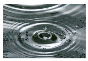
Fig. 6.1. Precipitation. (Source: http://www.kidsgeo.com/geography-for-kids/0111-precipitation.php)
Most of the condensed water in clouds does not fall as precipitation because their fall speed is not large enough to overcome updrafts which support the clouds. The water cycle in the environment is shown in Fig. 6.2.
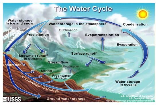
Fig. 6.2. The water cycle. (Source: http://en.wikipedia.org/wiki/File:Water_cycle.png)
6.2 Precipitation Process (Hydrological Cycle)
Hydrology is the science, which deals with the occurrence, distribution and disposal of water on the planet earth. It is the science which deals with the various phases of the hydrologic cycle. The hydrologic cycle, as illustrated in Fig. 6.3, is a conceptual model that describes the storage and movement of water between the biosphere, atmosphere, lithosphere, and the hydrosphere. Water on our planet can be stored in any one of the following major reservoirs: atmosphere, oceans, lakes, rivers, soils, glaciers, snowfields, and groundwater. Water moves from one reservoir to another by way of processes like evaporation, condensation, precipitation, deposition, runoff, infiltration, transpiration, melting, and groundwater flow. The oceans supply most of the evaporated water found in the atmosphere. Out of this evaporated water, only 91% is returned to the ocean basins by way of precipitation. The remaining 9% is transported to areas over landmasses where climatological factors induce the formation of precipitation. The resulting imbalance between rates of evaporation and precipitation over land and ocean is corrected by runoff and groundwater flow to the oceans. The globe has one-third land and two third as water bodies. Water is more or less constantly moving and changing from one state to another (solid, liquid, or vapor/gas) while interacting with the physical processes present in the atmosphere, lithosphere, and biosphere. These changes and movements of water are linked together in the hydrologic cycle. Components of the hydrologic cycle not only include water vapor and clouds in the atmosphere, but also include liquid surface waters (oceans, lakes and streams) on continents as well as groundwater.
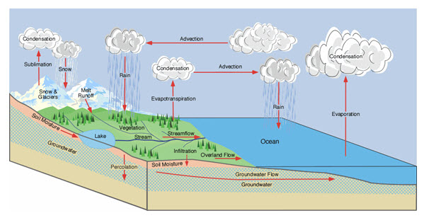
Fig. 6.3. Hydrologic cycle. (Source: http://www.eoearth.org/article/Hydrologic_cycle)
Evaporation takes place from the surfaces of ponds, lakes, reservoirs, ocean surfaces, etc. and transpiration from surface vegetation, as illustrated in Fig. 6.4, from plant leaves of cropped land and forests, etc. These vapours rise up and are condensed at higher altitudes due to cooler temperature to form clouds, resulting in droplet growth and eventually falling onto the earth as precipitation. A part of this precipitation flows over the land as runoff and a part infiltrates into the soil which builds up the groundwater table. The surface runoff joins the streams and rivers, which deliver the water into the seas and the oceans. Rainfall as well as runoff water is also stored in natural depressions and constructed ponds. This water is subjected to evaporation and seepage. Evaporation goes to the atmosphere and seepage joins the groundwater table. The groundwater also moves along the phreatic surface slope. A portion of the surface runoff as well as groundwater flows back to ocean. Again evaporation starts from the surfaces of lakes, reservoirs and ocean, and the cycle repeats. Evaporation, precipitation and runoff are three phases of the hydrologic cycle. The ‘runoff phase’, which is important to agricultural and civil engineers since they are concerned with the storage of surface runoff in tanks and reservoirs for the purposes of irrigation, municipal water supply, hydroelectric power generation, etc.
Rainfall is the purest form of natural water and is the source of all fresh water of the earth. Water melted from snow is also in a pure form but by the time it becomes available through rivers and streams, it is contaminated to varying extents depending on the terrain it traverses.
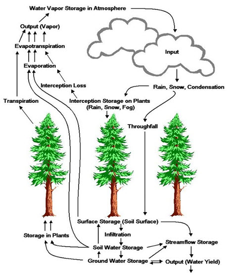
Fig. 6.4. Hydrologic Cycle. (Source: http://www.eoearth.org/article/Hydrologic_cycle)
Global Scale
On an annual basis, approximately 100 cm of water is evaporated from the surface area of oceans. Oceans, which also happen to be the dominant pool in the global water cycle, contain approximately 1,350,000 km3 of water. Of this, approximately 425,000 km3 are evaporated to the atmosphere each year, 385,000 km3 is returned directly to the oceans via precipitation, and 40,000 km3 is delivered to land by rainfall (net transport to land). At any given time, the atmosphere contains about 13,000 km3 water, or approximately 0.3 cm of rainfall. It is the large quantities of annual water movement through the atmosphere that results in 111,000 km3 being precipitated upon land and vegetation and 71,000 km3, which is either evaporated or transpired (evapotranspiration). Polar and glacial ice reservoirs account for approximately 33,000,000 km3 of water; water held in soils is equal to approximately 122,000 km3, and groundwater basins hold approximately 15,300,000 km3 ( http://www.eoearth.org/article/Hydrologic_cycle). Table 6.1 represents the different form of precipitation and their atmospheric condition based on their size and availability.
Table 6.1. Forms of Precipitation
|
Drizzle |
a light steady rain in fine drops (0.5 mm) and intensity <1 mm/h |
|
Rain |
the condensed water vapour of the atmosphere falling in drops (>0.5 mm, maximum size—6 mm) from the clouds. |
|
Glaze |
freezing of drizzle or rain when they come in contact with cold objects. |
|
Sleet |
frozen rain drops while falling through air at subfreezing temperature. |
|
Snow |
ice crystals resulting from sublimation (i.e., water vapour condenses to ice) |
|
Snowflakes |
ice crystals fused together |
|
Hail |
small lumps of ice (>5 mm in diameter) formed by alternate freezing and melting, when they are carried up and down in highly turbulent air currents. |
|
Dew |
moisture condensed from the atmosphere in small drops upon cool surfaces. |
Classification of Rain based on Intensity
Climatic factors include the amount and intensity of precipitation, the average temperature, as well as the typical temperature range, seasonality, wind speed, and storm frequency. In general, given similar vegetation and ecosystems, areas with high-intensity precipitation, more frequent rainfall, more wind, or more storms are expected to have more erosion. Rainfall intensity is the primary determinant of erosivity, with higher intensity rainfall generally resulting in more erosion. The size and velocity of rain drops is also an important factor. Larger and higher-velocity rain drops have greater kinetic energy, and thus their impact will displace soil particles over larger distances than smaller, slower-moving rain drops.
Rainfall intensity is classified according to the rate of precipitation:
Light rain — when the precipitation rate is < 2.5 millimeters (0.098 in) per hour
Moderate rain — when the precipitation rate is between 2.5 millimeters (0.098 in) - 7.6 millimeters (0.30 in) or 10 millimeters (0.39 in) per hour
Heavy rain — when the precipitation rate is > 7.6 millimeters (0.30 in) per hour, or between 10 millimeters (0.39 in) and 50 millimeters (2.0 in) per hour
Violent rain — when the precipitation rate is > 50 millimeters (2.0 in) per hour
Cloud burst
Cloud burst is one of the major natural disasters in the Himalayan region. It is a sudden heavy downpour over a small region and causes devastating flash floods. The cloudbursts are among the least known mesoscale weather systems, characterized by very high intensity rainfall greater than 100 mm per hour occurring over short duration. Ground monitoring stations are hardly able to capture the storm characteristics due to its highly localized occurrence. Deep cumulus convective clouds cause heavy rainfall over a limited horizontal area, within a short span of time. Such types of extreme rainfall events are most common over the high elevated areas of Northern India during the Southwest monsoon season which causes widespread damage to the property and lives.
6.3 Types of Precipitation
There are different kinds of precipitation:
(1) Orographic
(2) Convectional and
(3) Cyclonic
(1) Orographic Precipitation
Orographic precipitation, as schematic diagram Fig. 6.5, results when warm moist air moving across the ocean is forced to rise over large mountains. As the air rises, it cools. Cold air cannot hold as much moisture as warm air. Clouds form and precipitation occurs on the windward side of the mountain. The air becomes dry and rises over top of the mountain. As the air moves down the mountain, it collects moisture from the ground via evaporation. This side of the mountain is called the leeward side. It receives very little precipitation.
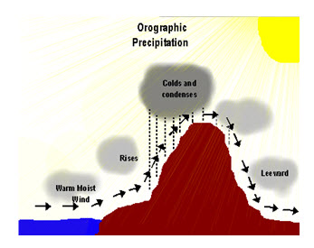
Fig. 6.5. Orographic precipitation. (Source: https://www.oakbay.sd61.bc.ca/staff/cataylor/SS10%20Precipitation%203%20Types%20Diagrams.pdf)
(2) Convectional Precipitation
Convectional precipitation results from the heating of the earth's surface. The warm ground heats the air over it. As the air warms up, the air molecules begin to move further apart. With increased distance between molecules, the molecules are less densely packed. Thus, the air becomes “lighter” and rises rapidly into the atmosphere. As the air rises, it cools. Water vapour in the air condenses into clouds and precipitation, as shown in schematic diagram Fig. 6.6. This type of precipitation is common in the Prairies and Ontario.
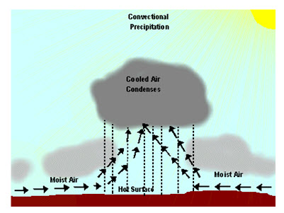
Fig. 6.6. Convectional precipitation. (Source: https://www.oakbay.sd61.bc.ca/staff/cataylor/SS10%20Precipitation%203%20Types%20Diagrams.pdf)
(3) Cyclonic Precipitation
Cyclonic or frontal precipitation, as shown in Fig. 6.7, results when the leading edge of a warm, moist air mass (warm front) meets a cool and dry air mass (cold front). The molecules in the cold air are more tightly packed together (i.e., more dense), and thus, the cold air is heavier than the warm air. The warmer air mass is forced up over the cool air. As it rises, the warm air cools, the water vapour in the air condenses, and clouds and precipitation result. This precipitation is common in Atlantic Canada. This type of system is called Frontal Precipitation because the moisture tends to occur along the front of the air mass. A cyclonic storm is a large, low pressure system that forms when a warm air mass and a cold air mass collide. This collision often occurs under the polar-front jet stream which spreads cold, dry arctic air near warm, moist tropical air. The rotation of the earth causes the air to circulate in a counterclockwise direction around an area of low pressure.
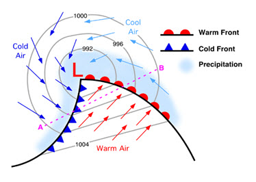
Fig. 6.7. Cyclonic precipitation. (Source:http://www.oakbay.sd61.bc.ca/staff/cataylor/SS10%20Precipitation%203%20Types%20Diagrams.pdf)
6.4 Characteristics of Precipitation
The Indian subcontinent has two major seasons and two transition periods as follows:
South-West Monsoon (June to September): It is the major rainy season in most parts of India (except the SE part of the peninsula and J&K) accounting for about 75% of the annual rainfall. Monsoon winds advance across the country in two branches viz. The Arabian Sea branch and the Bay of Bengal branch. A low pressure region called monsoon trough is formed between the two branches extending from the Bay of Bengal to Rajasthan. The precipitation pattern over the country is determined by its position.
Post Monsoon (North-East Monsoon) (October-November): As the South West monsoon retreats, low pressure regions form in the Bay of Bengal and a north-easterly flow of air that picks up moisture in the Bay of Bengal is formed. This strikes the east coast of the peninsula causing rain. Also several tropical cyclones form in the Bay of Bengal and the Arabian Sea during this period.
Winter (December to February): Western disturbances cause moderate to heavy rainfall and snowfall in the Himalayas and J&K. Some light rainfall also occurs in northern plains. Low pressure area in Bay of Bengal formed during these months causes 10-12 cm of rainfall in the southern parts of Tamil Nadu.
Summer (Pre-monsoon – March to May): There is very little rainfall in India. Convective cells cause some rain mainly in Kerala, West Bengal and Assam.
6.5 Erosivity and Erodibility
Erosivity is defined as the potential ability of rain to cause the erosion. It is dependent upon the physical characteristics of rainfall, which include raindrop size, drop size distribution, kinetic energy, terminal velocity etc.
Factors Influencing Erosivity
Erosivity is the potential capacity of rain to cause erosion. The various factors, which affect the erosiveness of rain storm, are given below:
i) Rainfall intensity
ii) Drop size distribution
iii) Terminal velocity
iv) Wind velocity
v) Direction of slope
Erodibility
It is the susceptibility of the soil to get eroded, and is a function of physical characteristics of soil and land management practices. The physical characteristics of soil include the texture, structure, organic matter, land use pattern. On the basis of erodibility, one soil can be compared quantitatively with the other for a given rainfall condition. Small sizes of particles are more erodible than the larger particles; thus the soil composed of high silt content is more erodible.
Last modified: Thursday, 19 September 2013, 9:47 AM