Site pages
Current course
Participants
General
Module 1: Formation of Gully and Ravine
Module 2: Hydrological Parameters Related to Soil ...
Module 3: Soil Erosion Processes and Estimation
Module 4: Vegetative and Structural Measures for E...
Keywords
29 March - 4 April
5 April - 11 April
12 April - 18 April
19 April - 25 April
26 April - 2 May
Lesson 13 Runoff Hydrograph - I
13.1 Introduction
A plot of the discharge in a stream plotted chronologically against time is called a Hydrograph. Hydrograph is the graphical representation of the response of the watershed for a given storm as input.
Chow (1964) stated that hydrograph can be regarded as an integral expression of physiographic and climatic characteristics that govern the relation between the rainfall and runoff of a particular drainage basin. It shows the time distribution of runoff at the point of measurement, defining the complexities of the basin characteristics by a single empirical curve. Generally, a stage recorder is installed in the channel to obtain the hydrograph of the stream flow.
When a rainstorm occurs, a part of it remains on the land surface after accounting for the initial abstraction and infiltration losses. This reaches the drainage channels or the stream through overland and channel flow of rainfall excess. The process of overland and channel flows of rainfall excess is known as translation. During the process of translation, storage is built up both in the overland and channel flow phases, and the storage gradually depletes after the rainfall stops. Thus, there is a time lag between the time of initiation of rainfall and the time when the rainfall excess reaches the outlet of the watershed, where the runoff is measured by a stage level recorder or by manually noting the stage of flow at different times.
The intensity of rainfall, the time of concentration of the watershed, the succession of storms, the groundwater recession pattern and similar other factors determine the peak of a hydrograph. A concentrated storm of rainfall over an isolated duration produces a single-peaked skewed-distributed hydrograph. In other cases when storm rainfalls are separated by short time intervals or when rain storms of varying intensities occur over an extended time period, multiple-peaked hydrographs are likely to occur. A multiple peaked hydrograph can be separated into a number of single peaked hydrograph, when required for analysis.
13.2 Flood Hydrograph
Flood hydrograph is the hydrograph generated due to storm runoff. It is also called storm hydrograph or runoff hydrograph. Fig.13.1 shows the flood hydrograph. The flood hydrograph consists of all the three phases of runoff, viz. surface runoff, inter flow and base flow.
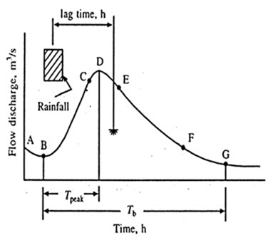
Fig. 13.1. Flood hydrograph. (Sources: Das, 2002)
Depending upon the unit of time involved, the hydrographs are classified as:
(a) Annual hydrograph
(b) Monthly hydrograph
(c) Seasonal hydrograph
(d) Flood hydrograph
(a) Annual Hydrograph
Annual hydrograph represents the variation of daily or weekly or 10 daily mean flow over a year.
(b) Monthly Hydrograph
Monthly hydrograph represents the variation of daily mean flows over a month.
(c) Seasonal Hydrograph
Seasonal hydrograph represents the variation of the discharge in a particular season such as the monsoon season or dry season.
(d) Flood Hydrograph
Flood hydrograph or simply hydrograph represents stream flow due to a storm over a catchment.
Each of these types has specific applications. Annual or seasonal hydrograph is used in calculating the surface water potential of stream, reservoir studies and drought studies. Whereas, flood hydrographs are essential in analyzing stream characteristics associated with floods.
13.3 Factors Affecting Flood Hydrograph
The factors that affect the shape of the hydrograph can be broadly grouped into two categories as given below:
(i) Physiographic factors
(ii) Climatic factors
(i) Physiographic Factors
The physiographic factors are:
(1) Basin Characteristics:
(a) Shape
(b) Size
(c) Slope
(d) Drainage density
(e) Nature of the valley
(f) Elevation
(2) Infiltration Characteristics:
(a) Land use/ land cover
(b) Soil type and geological conditions
(c) Lake, swamps and other storages
(3) Channel Characteristics:
(a) Channel cross section
(b) Roughness
(c) Storage capacity
(ii) Climatic Factors:
The climatic factors are
(1) Storm Characteristics:
(a) Precipitation
(b) Intensity
(c) Duration
(d) Magnitude
(e) Movement of storm
(2) Initial Loss
(3) Evaporation
The rising limb of the hydrograph is dependent upon both physiographic and climatic factors, whereas; the recession limb depends only upon physiographic factors.
Some of the important physiographic and climatic factors are describe below.
(i) Physiographic Factors:
Shape of the Basin
The effect of catchment shape on hydrograph is illustrated in fig. 13.2.
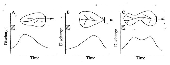
Fig. 13.2. Effect of catchment shape on hydrograph. (Sources: Subramanya, 1994)
The Shape of the basins influences the time taken for water from the remote parts of the catchment to arrive at outlet. Thus the occurrence of peak and hence the shape of hydrograph are affected by basin shape. Fan shaped, that is semi-circular shaped catchments give sharp and narrow hydrographs while the elongated catchments give broad and low peaked hydrographs.
Size of the Basins
Small basins behave differently from large ones in terms of the relative importance of various phases of runoff phenomenon. Effect of basin size is illustrated in Fig. 13.3. In small basins the overland flow phase is predominant over the channel flow, whereas; in large basins channel flow is predominant. The peak is high in a large basin than in a small basin as peak discharge is found to vary as An, where A is the catchment area and n is an exponent whose value is less than unity, being about 0.5. The base of hydrograph from larger basins will be larger than those of corresponding hydrographs from smaller basins.
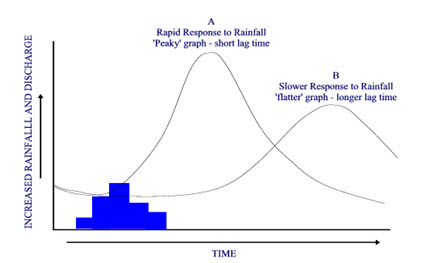
Fig. 13.3. Effect of basin size on hydrograph. (Sources: https://www.cgz.e2bn.net)
Slope
The slope of the main stream controls the velocity of flow in the channel. As the recession limb of the hydrograph represents the depletion of storage, the stream channel slope will have a pronounced effect on this part of the hydrograph. Large stream slopes give rise to quicker depletion of storage and hence result in steeper recession limb of hydrograph and smaller time base. The effect of channel slope is illustrated in fig. 13.4.
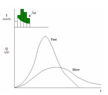
Fig. 13.4. The effect of channel slope on hydrograph. (Source: https://www.daad.wb.tu-harburg.de)
The basin slope is important in small catchment where the overland flow is more important. In such cases the steeper slope of the catchment results in larger peak discharge.
Drainage Density
The drainage density is a measure of the total length of well-defined channels that drain the catchment (sometimes measured as the blue lines representing the streams on a topographic map). Drainage density is defined as the sum of the lengths of all of the channels (km) divided by the total catchment area (km2). This ratio can be determined from topographical maps. The effect of drainage density on hydrograph is illustrated in Fig.13.5. Drainage density affects the response of the catchment to rainfall. High densities usually allow fast runoff removal. Therefore, hydrographs having greater peaks and with shorter durations are expected for catchments with higher drainage densities. In catchment with smaller drainage densities, the overland flow is predominant and the resulting hydrograph is squat with a slowly rising limb.
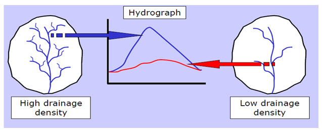
Fig. 13.5 Effect of drainage densities on hydrograph. (Source: http://www.lanarkgrammargeography.pbworks.com)
Land Use
Vegetation and forests increase the infiltration and storage capacities of the soils. Further they cause considerable retardance to the overland flow. Thus vegetal cover reduces the peak flow. In general, for two catchments of equal area, other factors being identical, the peak discharge is higher for a catchment that has a lower density of forests cover. The effect of land use on hydrograph is shows in fig. 13.6.
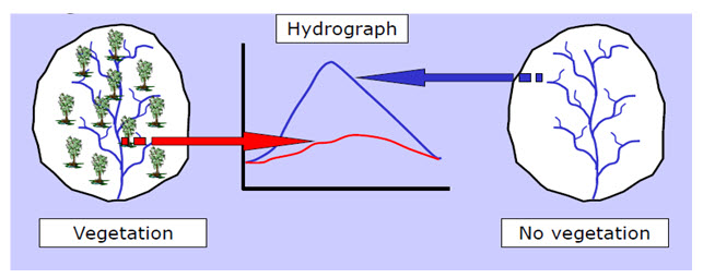
Fig. 13.6 Effect of land use on hydrograph. (Source: http://www.lanarkgrammargeography.pbworks.com)
Channel Roughness
Roughness affects the velocity of overland flow and stream flow. A rough channel will cause smaller peaks than a smooth channel. For a given discharge, stage levels (water surface elevations) in a stream are higher for rough channels.
Storage Capacity
Storage can take place within the streambed, flood plains, marshes, lakes, or in artificial features such as storm water management facilities and reservoirs. Storage also takes place in the impoundments created upstream of road crossings (e.g., bridges, and culverts). In general, storage reduces and delays the peaks and increases the duration of runoff.
(ii) Climatic Factors
Among the climatic factors the intensity, duration and direction of storm movement are the three important ones affecting the shape of flood hydrograph.
Intensity
For a given duration, the peak and volume of the surface runoff are essentially proportional to the intensity of rainfall.
Duration
The duration of storm for a given intensity also has a direct proportional effect on the volume of runoff. The effect of duration is reflected in the rising limb of the peak flow.
Storm Movement
If the storm moves from upstream of the catchment to the downstream end, there will be a quicker concentration of flow at the basin outlet. This results in a peaked hydrograph. Conversely, if the storm movement is up the catchment, the resulting hydrograph will be a lower peak and longer time base.
Last modified: Monday, 23 September 2013, 4:27 AM