Site pages
Current course
Participants
General
Module 1: Formation of Gully and Ravine
Module 2: Hydrological Parameters Related to Soil ...
Module 3: Soil Erosion Processes and Estimation
Module 4: Vegetative and Structural Measures for E...
Keywords
29 March - 4 April
5 April - 11 April
12 April - 18 April
19 April - 25 April
26 April - 2 May
Lesson 10 Runoff
10.1 Introduction
There are a number of definitions of runoff that have been used either explicitly or implicitly in hydrological analyses over the years. Runoff is the part of the rainfall over a catchment area that eventually leaves the catchment as a surface stream flow, whatever is the flow pathway that the water has followed on its way to the stream channel. Thus this definition includes both surface and subsurface runoff pathways.
10.1.1 Runoff Processes in Rural Areas
In arid and semi-arid regions with scarce vegetation and those disturbed by humans (urbanization, etc.), infiltration capacity is a limiting factor and Hortonian overland flow is the dominant process. This also happens when the top soil is frozen. In most humid regions, subsurface flow and saturation overland flow are dominant processes. Where the soils are well-drained, deep and very permeable, the water table is deep and the saturated zone is confined to the valley floor. Saturated overland flow is less important than subsurface flow in this situation. Where the soils are thin, only moderately permeable, and slope is gentle and concave shaped, the water table is shallow and the saturated zone expand readily, the saturated overland flow dominates in this situation.
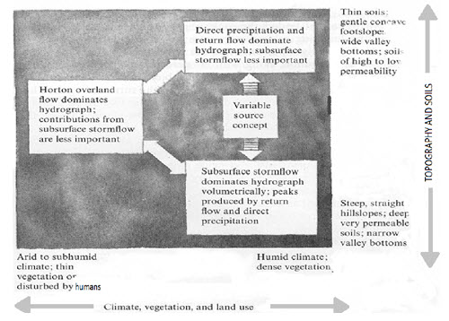
Fig. 10.1. Runoff process for different soils, vegetation and land use. (Source: http://people.ucalgary.ca/~hayashi/geog515/lectures/515_0607.pdf)
10.1.2 Runoff Processes in Urban Areas
Modification of the land surface during urbanization changes the type and magnitude of runoff processes. Covering parts of the catchment with impervious roofs and concrete lots increases the volume and rate of Horton overland flow. Planners have to design detention ponds to accommodate increased runoff. Gutters and storm sewers convey runoff rapidly to stream channels. The channels are straightened and lined with concrete to increase the efficiency, so that they transmit the flood wave downstream more quickly. A storm hydrograph after urbanization has larger peak flow and shorter lag time than before. The capacity of culverts and bridges are overtaxed and residential areas become flooded during large storms.
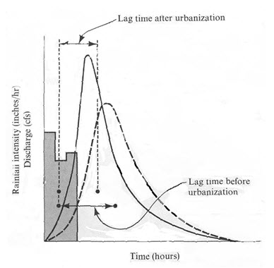
Fig. 10.2. Effects of urbanization on storm hydrographs. (Source: http://people.ucalgary.ca/~hayashi/geog515/lectures/515_0607.pdf)
10.1.3 Human Activities Affecting Runoff
As population grows and as more development and urbanization occur, more of the natural and pervious landscape is replaced by impervious surfaces, such as roads, houses, parking lots and buildings that reduce infiltration of water into the ground and accelerate runoff to ditches and streams. In addition to increasing imperviousness, deforestation, grading of land surface, construction of drainage networks increase runoff volumes and shorten runoff time into streams from rainfall and snowmelt. As a result, the peak discharge, volume, and frequency of floods increase in streams.
10.1.4 Runoff Cycle
It is that part of hydrological cycle which falls between the phase of precipitation and its subsequent discharge in the stream channels or direct return to the atmosphere through evaporation and evapotranspiration.
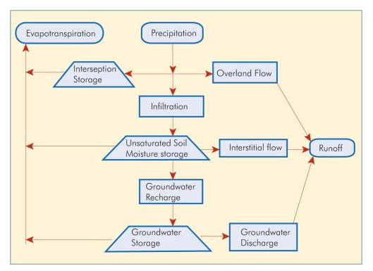
Fig. 10.3. Runoff cycle. (Source: http://texeresilk.com/jquery/14/runoff-cycle)
10.1.5 Conditions Associated With Runoff Cycle
As a result of occurrence of a storm rainfall event, from the water that reaches the land surface after satisfying in interception by the vegetation, temporary surface and channel storage build up. The water then starts flowing governed by gravity force when the localized depressions are filled up by water.
This process continues simultaneously with infiltration and the channel flow component increases, flowing towards larger streams, tributaries and rivers. The infiltrated water first fills up soil pores in the upper soil layers after which the excess water joins the groundwater table.
After this stage and when the rainfall stops, there is no further supply of water and the channel flows start depleting. Meanwhile, the larger surface depressions, ponds, lakes and reservoirs gradually get replenished.
The flow that continues thereafter through the rivers flow towards the seas and the oceans.
10.2 Types of Runoff
Based on the time lag between rainfall and runoff, it may be classified in to the following three types:
Surface runoff.
Sub - surface runoff, and
Base flow.
1. Surface Runoff
It is the portion of rainfall which enters the stream immediately after the rainfall when the localized depressions are filled up and the top soil layer is saturated. The short journey of this water flowing over the land as a sheet of water is also called overland flow. This overland flow soon finds paths of lesser resistance such as rills, streams, tributaries, rivers, etc., which all combined is termed as surface runoff.

Fig. 10.3. Surface runoff. (Source: http://milford.nserl.purdue.edu/weppdocs/overview/runoff.html)
2. Sub-surface Runoff
The portion of rainfall, which first infiltrates into the soil and moves laterally without joining the water-table to the streams, rivers or oceans is known as sub- surface runoff. The sub-surface runoff is usually referred to as interflow.
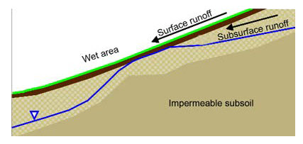
Fig. 10.4. Sub-surface runoff. (Source: http://www4.agr.gc.ca/AAFC-AAC/display-afficher.do?id=1294678601507)
3. Base flow
It is the delayed flow, defined as that part of rainfall which after falling on the ground surface infiltrates into the soil and meets the water table and flow towards the streams, rivers, oceans etc. The movement of water in this type of runoff is very slow; that is why it is also referred to as delayed runoff. It takes a long time to join the rivers or oceans. Sometimes base flow is also known as ground water flow. Base flow is not directly contributed by rainfall and continues much after the rainfall has ceased. In very large catchments and also for snow covered catchments, base flow continues throughout the year giving rise to perennial rivers, as against seasonal rivers, which dry up during the summer. Thus,
Total Runoff = Surface runoff + Base flow (Including sub - surface runoff)
Fig. 10.5. Base flow. (Source: http://www.bigelow.org/virtual/water_sub2.html)
Special Case of Runoff Generation by Snowmelt
Many hydrological regimes, particularly mountain regimes, are dominated by the spring snowmelt component. Snowmelt has particular characteristics in generating the snowmelt hydrograph. It tends to have only low intensities since even after the snowpack is "ripe" and ready for melt, rates of melt are limited on a daily basis by the energy available to supply the latent heat necessary to convert ice and snow to liquid water. Initially, routing through the snowpack may also diffuse the daily melt signal, and there may be some refreezing of water at night. Another interesting feature of the melt process is that it will have a characteristic spatial pattern since, in general, south facing slopes will melt before north facing slopes (in the Northern Hemisphere) and a low elevation snowpack before a high elevation pack. There may also be spatial variations in melt associated with differences in the storage of snow as a result of drifting during the winter period. The response of a catchment during the snowmelt period may depend very much on the state of the soil. If the soil is frozen, then it is likely that infiltration rates may be limited and there is a greater chance of the melt generating a downslope surface runoff through the base of the pack. If the soil is unfrozen, then the low intensity of the melt will usually mean that the bulk of the melt will infiltrate into the soil profile. Depending on the weather conditions prior to a pack being established, it is quite possible that in some years the soil surface remains frozen all winter, while in other years the surface is unfrozen at the start of the melt season.
10.3 Factors Affecting Runoff
Runoff rate and volume from an area are mainly influenced by following four factors:
A. Climatic factors.
B. Physiographical Factors.
C. Metrological factors
D. Storage Characteristics
(A) Climate Factors
It is associated with characteristics of precipitation which includes:
1. Types of Precipitation
It has great effect on the runoff. Precipitation which occurs in the form of rainfall starts immediately as surface runoff depending upon rainfall intensity while precipitation in the form of snow does not immediately result in surface runoff. It does so only after the snow is melted.
2. Rainfall Intensity
If the rainfall intensity is greater than infiltration rate of soil then runoff starts immediately after rainfall. While in case of low rainfall intensity, runoff starts later. Thus high intensities of rainfall yield higher runoff. Under a monsoon climate, as over India, rainfall intensities are generally higher than the infiltration rate and it is quite common to find runoff occurring even when the lower soil layers remain unsaturated.
3. Duration of Rainfall
It is directly related to the volume of runoff because infiltration rate of soil decreases with duration of rainfall. Therefore medium intensity rainfall even results in considerable amount of runoff if duration is longer.
4. Rainfall Distribution
Runoff from a watershed depends very much on the distribution of rainfall. It is related to the direction of storm movement: from outlet of the catchment upstream and vice-versa. It is also expressed as “distribution coefficient” mean ratio of maximum rainfall at a point to the mean rainfall of watershed. Therefore, near outlet of watershed runoff will be more.
5. Direction of Prevailing Wind
If the direction of prevailing wind is same as drainage system, it results in low peak. A storm moving in the direction of stream slope produces a higher peak in shorter period of time than a storm moving in opposite direction.
6. Other Climate Factor
Other factors such as temperature, wind velocity, relative humidity, annual rainfall etc., affect the water losses from watershed area.
(B) Physiographic Factors
These include both watershed and channel characteristics, which are as follows:
1. Size of Watershed
A large watershed takes longer time for draining the runoff to outlet than a smaller watershed and vice-versa.
2. Shape of Watershed
Runoff is greatly affected by shape of watershed. Shape of watershed is generally expressed by the term “form factor” and “compactness coefficient”.
Form Factor is ratio of average width to axial length of watershed
F= B/L
F, dimensionally equal to A/{(L).(L)} = A/L2
Compactness Coefficient
Ratio of perimeter of watershed to circumference of circle whose area is equal to area of watershed
Two types of shapes
a. Fan shape [tends to produce higher runoff very early]
b. Fern shape [tend to produce less runoff].
3. Slope of Watershed
It has complex effect. It controls the time of overland flow and time of concentration of rainfall. For example, a sloppy watershed results in greater runoff due to greater runoff velocity and vice-versa.
4. Orientation of Watershed
This affects the evaporation and transpiration losses from the area. The north or south orientation, affects the time of melting of collected snow.
5. Land Use
Land use and land management practices have great effect on the runoff yield. For example, an area with forest cover or thick layer of mulch of leaves and grasses contribute less runoff because water is absorbed more into soil.
6. Soil moisture
Magnitude of runoff yield depends upon the initial moisture present in soil at the time of rainfall. If the rain occurs after a long dry spell then infiltration rate is more, hence it contributes less runoff.
7. Soil type
Infiltration rate vary with type of soil. So runoff is greatly affected by soil type.
8. Topographic characteristics
It includes those topographic features which affects the runoff. Undulated land has greater runoff than flat land because runoff water gets additional energy [velocity] due to slope and less time to infiltrate.
9. Drainage Density:
It is defined as the ratio of the total channel length [L] in the watershed to total watershed area [A]. Greater drainage density gives more runoff
Drainage density = L/A
(C) Metrological factors
a. Temperature,
b. Humidity
c. Wind velocity
d. Pressure difference
(D) Storage Characteristics
a. Depressions
b. Ponds, lakes and pools.
c. Stream
d. Channels.
e. Check dams in gullies
f. Upstream reservoirs or tanks.
g. Ground water storage in deposits/aquifers