Site pages
Current course
Participants
General
Module.1 Introduction of Water Resources and Hydro...
Module.2 Precipitation
Module.3 Hydrological Abstractions
Moule.4 Types and Geomorphology of Watersheds
Module 5. Runoff
Module 6. Hydrograph
Module 7. Flood Routing
Module 8. rought and Flood Management
Lesson 4 Forms and Types of Precipitation
4.1 Forms of Precipitation
Precipitation occurs in many forms e.g. drizzle, rain, glaze, sleet, snow, hail, dew and frost, depending upon the causes and temperature at the time of formation. Dew is condensation on the ground of atmospheric vapor caused by radiational cooling of the lower layers of atmosphere, usually at night. Frost is dew formed under freezing conditions. Dew and frost are quantitatively unimportant and rarely measured.
- Drizzle: Drop size < 0.5 mm in dia. and intensity is usually < 1 mm/hr and generally occurs in conjunction with warm frontal lifting.
- Rain: Drop size is between 0.5 to 6 mm in dia. Drops bigger than 6 mm tend to break up as they fell. It is formed by condensation and coalescence of cloud droplets at temperatures above the freezing point.
- Glaze: It is the ice coating formed when drizzle or rain freezes as it comes in contact with cold objects on the ground.
- Sleet: It is frozen raindrops cooled to ice stage while falling through air at sub-freezing temperature.
- Snow: It is a precipitation in the form of ice crystals resulting from sublimation, i.e., directly from water vapor to ice.
- Snow Flake: It is made of a number of ice crystals fused to gather.
- Hail: It is precipitation in the form of balls or lumps of ice over 5 mm diameter formed by alternate freezing and melting as they are carried up and down in highly turbulent air currents.
4.2 Mechanisms for Production of Rainfall
The following four conditions are necessary for the production of rainfall.
4.2.1 Mechanism to produce cooling of the air – The pressure reduction due to ascending air from surface to upper levels in the atmosphere is the only known mechanism capable of producing large drops in the temperature.
4.2.2 Mechanism to produce condensation – Condensation in the atmosphere takes place on “hygroscopic nuclei” small particles of substances that have an affinity for water.
4.2.3 Mechanism for droplet growth – A tendency for the droplets to remain small and therefore to resist falling is called “colloidal stability”. The most effective processes for droplet enlargement are,
- the difference in speeds between large and small droplets, and
- The co-existence of ice crystals and water droplets.
4.2.4 to produce accumulation of moisture of sufficient intensity to account for the observed rates of rainfall – Regardless of whether or not the other conditions for precipitation are fulfilled, continuity considerations demand that there must be a good amount of moisture present in the atmosphere so that evaporation losses between ground and cloud be compensated, if there is to be appreciable rain.
4.3 Types of Precipitation
There are three major types of precipitation: cyclonic, convective, and orographic. Each type represents a different method of lifting an air mass, resulting in cooling and condensation of atmospheric water vapor.
4.3.1 Cyclonic Precipitation: It is caused by lifting associated with the horizontal convergence of inflowing atmosphere into an area of low pressure. There are two kinds of cyclonic precipitation. Non-frontal precipitation involves only this convergence and lifting. Frontal precipitation results when one air mass is lifted over another. A front is defined as the boundary between two air masses of different temperatures and densities. The types of fronts and their commonly associated precipitation are described below.
A warm front is the result of a warm air mass overriding a cold air mass, causing extensive areas of cloudiness and precipitation. As the warm front approaches a given area, the precipitation becomes more continuous and intense. Warm fronts move at a speed of 15-50 km/h (10-30 mph).
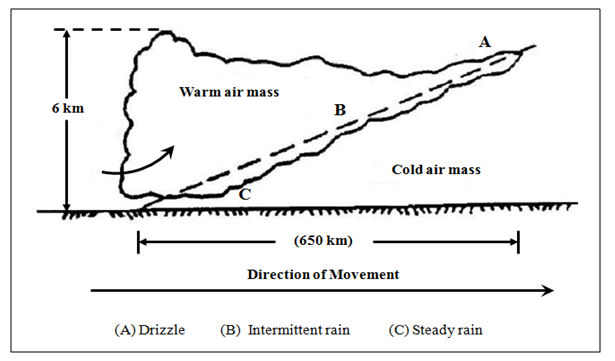
Fig.4.1.Warm Front.(Source:Singh, 1994)
A cold front results from a strong push of a cold air mass against and beneath a warm air mass. At the front towering clouds develop together with intense short duration precipitation. Cold fronts move at a speed of 30-80 km/h (20-50 mph).
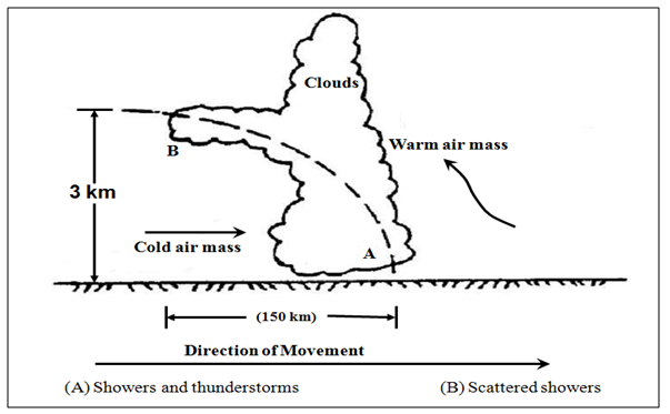
Fig.4.2.Cold Front.(Source:Singh, 1994)
An occluded front occurs when a cold front overtakes a warm front. The precipitation pattern is a combination of both warm and cold frontal distribution. Occluded fronts move at a speed of from 8-50 km/h (5-30 mph).
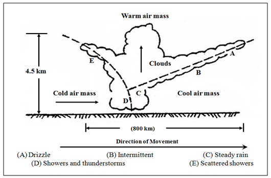
Fig.4.3.Occluded Front.(Source: Singh, 1994)
4.3.2 Convective Precipitation:
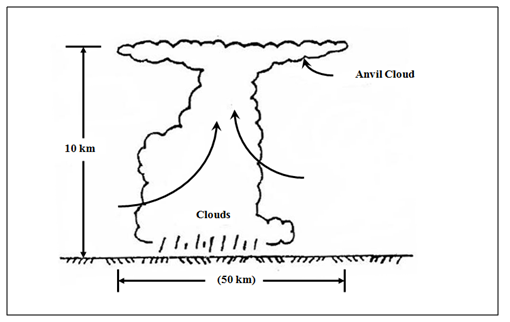
Fig.4.4.Thunderstorm.(Source:Singh, 1994)
It results when air that is warmer than its surrounding rises and cools. The precipitation is of a shower type, varying from light showers to cloudbursts. The typical thunderstorms resulting from heating of the atmosphere in the afternoon hours is the best example of convective rainfall. Thunderstorms occur throughout the world, especially in the summer. They are the characteristic form of rain in the tropics, wherever cyclonic circulation does not operate. A cross section through a typical thunderstorm is shown in the Fig 4.4
4.3.3 Orographic Precipitation: It is caused when air masses are lifted as they move over mountain barriers. Such orographic barriers tend to increase both cyclonic and orographic precipitation due to the increased lifting involved. Precipitation is generally heavier on the windward slope than on the leeward slope.
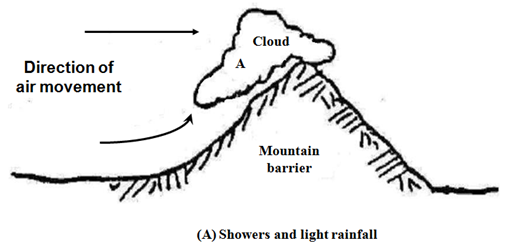
Fig.4.5.Orographic Precipitation.(Source:Singh, 1994)
References
Singh, V. P. (1994). Elementary Hydrology.Prentice Hall of India Private Limited,New Delhi.
Suggested Reading
Subramanya, K. (1994). Engineering Hydrology.Third edition, Tata McGraw Hill, New Delhi.
Murty, V.V.N. and Jha, M.K. (2009).Land and Water Management Engineering.Fifth edition, Kalyani Publishers, Ludhiana.
Last modified: Saturday, 1 March 2014, 11:17 AM