Site pages
Current course
Participants
General
Module 1: Introduction and Concept of Soil Erosion
Module 2: Water Erosion and Control
Module 3: Wind Erosion, Estimation and Control
Module 4: Soil Loss- Sediment Yield Estimation
Module 5: Sedimentation
Module 6: Topographic Survey and Contour Maps
Module 7: Land Use Capability Classification
Module 8: Grassed Waterways
Module 9: Water Harvesting
Module 10: Water Quality and Pollution
Module 11: Watershed Modeling
Keywords
Lesson 13 River Training and Stream Bank Protection
13.1 Introduction
A river is a natural watercourse, usually of freshwater, flowing towards an ocean, a lake, a sea, or another river. In a few cases, a river simply flows into the ground or dries up completely before reaching another body of water. Small rivers may also be called by several other names, including stream, creek, brook, rivulet, run, tributary and rill. Rivers are the main source of water to satisfy domestic, municipal, irrigation, industrial and energy production demands.
Rivers are part of the hydrological cycle and the cycle is completed by flowing of storm water or melted snow water though defined channels, finally discharging unutilized water back into sea. Water within a river is generally collected from precipitation through a drainage basin from surface runoff and other sources such as groundwater recharge, springs, and the release of stored water in natural ice and snow packs (e.g., from glaciers). Potamology is the scientific study of rivers while limnology is the study of inland waters in general. Rivers carry tremendous amount of silt and sediment washed out from catchment area or eroded from river bed and banks. Before going into the details of river training and stream bank protection, it is important to learn about the types of rivers and their characteristics.
13.2 Types of Rivers
Rivers can be classified using their topological characteristics as well as based on their flood hydrograph as follows:
13.2.1 Based on the Topology of River Basin
13.2.1.1 Rivers of Hills (Upper Reach)
The perennial rivers fed from ice and snow packs (from glaciers) take off from mountains, and flow through hilly regions before traveling through the plains. These upper reaches of the river may be termed as Rivers of hills. These rivers further have two characteristics to be further classified as given below.
Incised or rocky rivers: In these rivers, the flow channel is formed due to erosion in highly steep reaches and with swift flow forming rapids (Fig. 13.1). In these rivers, river beds and banks are less susceptible to erosion. Sediment in this reach is often different from the river bed material as most of it comes from catchment due to denudation and soil erosion. In these rivers, the bed load can not be determined on the basis of usual bed load transportation formula derived on the basis of bed characteristics.
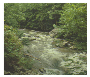
Fig. 13.1. Incised or Rocky Rivers.
(Source: http://www.nps.gov/ncrc/programs/rtca/nri/states/tn.html)
Boulder River: River bed consists of boulders, gravels, shingles and alluvial sand deposits (Fig. 13.2). These rivers flow through wide shallow beds and interlaced channels, and develops straight course. During floods, boulders, gravels, shingles are transported, get deposited downstream and form heaps when flood subsides. Normal water unable to shift these heaps goes around them, often attack the banks and consequently widen the bed.
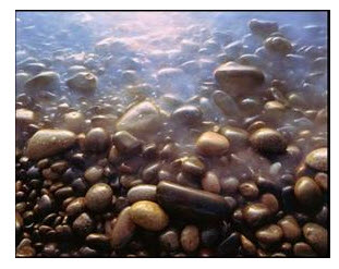
Fig. 13.2. Boulder River.
(Source: http://www.nps.gov/ncrc/programs/rtca/nri/states/tn.html)
13.2.1.2 Rivers in Alluvial Plains (Rivers in Flood Plains – Lower Reach)
After the boulder stage, a river enters the alluvial plains. The bed and banks are now made up of sand and silt. The bed slope and the velocity of flow in the river are much smaller than those of the boulder rivers. The cross-section of the river is decided by the sediment load and the erodibility of the bed and banks of the river. The sediment transported by such rivers is predominantly of the same type as the material forming the channel bed. During high floods, these rivers inundate very large areas and cause considerable damage to life, property, and crops. Such rivers are also called alluvial rivers.
These rivers, i.e. rivers in flood plain, follow zig-gag path- called meandering. Rivers meander freely, generating huge amount of sediment, and carry sediment similar to bed material. Soil gets eroded constantly from outer edge of the bend and gets deposited either on the inner edge or between two successive bends forming a bar. Once a straight moving river slightly deviates from its axis, the unbalance created goes on multiplying with constant erosion from the concave side and deposition on the convex side (Fig. 13.3). If these erosion processes are unchecked, the process continues, resulting in the formation of large meanders. Rivers in flood plains can be further classified as: aggrading or accreting type, degrading type, stable type, braided type, and deltaic type rivers.
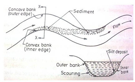
Fig. 13.3. Rivers in Alluvial Plains. (Source: Asawa, 1993)
Aggrading Rivers: These are silting river, collecting sediment and increasing their bed slope (building up of slope). The causes of silting could be heavy sediment load due to construction of obstruction across the river (dam and weir), sudden intrusion of sediment from tributary, etc. These rivers have straight and wide reaches with shoal in the middle.
Degrading Rivers: In these rivers, the bed is constantly eroded /scoured to reduce the land slope. The elevated bed soil is eroded and is transported by the flowing water. Under these conditions, the river bed slope is reduced to achieve more stable bed with reduced slope. These rivers are generally found below a dam or a weir or a barrage.
Stable Rivers: When the alignment of a river channel, river slope, and river regime are relatively stable and show little variation from year to year except that the river may migrate within its permanent banks, the river is said to be stable. However, changes in bed and plan-forms of a stable river do take place, but these are small.
Braided Rivers: River flows in two or more channels around alluvial island, developed after local deposition of coarser material (Fig. 13.4).
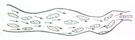
Fig. 13.4. Braided river. (Source: Asawa, 1993)
Deltaic Rivers: Rivers which before joining the sea get divided into branches, due to very flat bed slopes resulting in shoal formation and braiding of the channel, forming delta are called deltaic rivers (Fig. 13.5). The delta river indicates a stage, rather than a type of river.
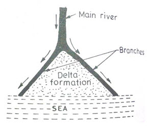
Fig. 13.5. Deltaic rivers. (Source: Asawa, 1993)
Tidal Rivers: After passing through the alluvial plain, the tail reaches of the rivers adjoining the oceans are affected by ocean tides. Ocean water enters into the river during the flood tide and moves back during ebb tide. Thus the river undergoes periodic rise and fall in its water level which creates water flush in the lower/last portion of the river. The distance affected due to this sudden water flush; causing disturbances due to water and sediments; depends on configuration of river, tidal range, freshet discharge etc.
13.2.2 Based on Flood Hydrograph
Flashy Rivers
In case of flashy rivers, the river stage rises and falls in a very short period of a day or two due to the steep flood hydrograph. A small flow may, however, continue for some time.
Virgin Rivers
In arid regions, waters of some rivers may get completely lost due to evaporation and percolation before meeting another water body. Such rivers become completely dry much before they join another river or sea, and are called virgin rivers.
13.3 Objectives of River Training
River training is an age-old practice resulting in incessant development and application of human ingenuity to correct vagaries of the rivers. It requires deep and precise study of river mechanism and behaviour discussed heretofore. River training has assumed considerable significance in India due to huge annual recurring damage caused by the floods; 80 per cent of which accounts for loss of crops. River training, in its broad aspects, covers all engineering works constructed on a river to guide and confine the flow to the river channel, and to control and regulate the river bed configuration for effective and safe movement of floods and river sediments. In essence, river training envisages training and stabilizing a river within a suitable waterway and along a certain alignment for a variety of purposes. River training works involve large outlays and it is essential to select the type of the training work and materials of construction so as to make optimum utilization of funds, and effective as well as economical utilization of the available construction materials.
The various objectives of river training are:
To guide the axis of flow at ordinary and low stages and safe passage of floods without overtopping the banks,
To protect the banks from erosion and generally improve their alignment by stabilizing the river channel,
To train the river flow along a safe course, thereby avoiding damage by flooding or erosion of valuable lands, habitations, crops, factories, etc.,
To prevent outflanking of a bridge, barrage or weir by directing the flow in a defined stretch of the river,
To prevent river from changing its course,
To confine a too wide river channel due to swinging from side to side and to reclaim the land from river bed,
To check certain devastations like flash torrents,
To trap bed load in areas of superfluous width,
To transport efficiently bed load and suspended sediment load,
To provide sufficient depth of flow for safe navigation,
To establish channel boundaries where braiding has been created too wide a section divided into small channels separated by islands, and
To correct disorderly banks or flow conditions.
13.4 Methods of River Training
The following types of river training works are generally adopted:
1. Guide bunds;
2. Spurs (Groynes);
3. Marginal bunds;
4. Closure bunds; and
5. Assisted cut offs.
13.4.1 Guide Bunds
The necessity of guide bunds is in confining and guiding the river flow through the structure without causing damage to it and its approaches. They also prevent the out flanking of the structure. The shape and design features of guide bunds provide necessary guidance to the flow. The guide bund can either be divergent upstream or parallel. In the case of divergent guide bund, there is possibility of formation of a shoal at the center. Parallel guide bunds minimize obliquity and separation of flow along the flanks. According to geometrical shape, the guide bunds may be straight or elliptical. In the case of certain type of alluvial rivers with sandy bed and meandering pattern, elliptical shape of guide bund appears to be preferable to minimize obliquity and separation of flow.
Normally the upstream shank of the guide bund is between 1.0 to 1.5 times the length of the bridge, while the downstream shank is between 0.2 to 0.4 times the length of the bridge. The tail bund on the downstream side is provided to afford an easy exit to the water and to prevent formation of vertical whirlpools or rollers which give rise to scour. These tail bunds are also curved at their ends and should be properly protected. The slope in the rear of the guide bund need not necessarily be provided with pitching and may be protected by planting suitable grass or shrubs.
Maintenance:
a) Substantial reserve of pitching stone should be maintained on the guide bund for use during emergency. This should be stacked at the top of the guide bund.
b) The track on the guide bund, where provided, should be maintained in a satisfactory condition. The track should be inspected soon after the monsoon every year and carry out necessary repairs well before the next monsoon.
c) Disturbance of pitching stone on the slope indicates dangerous condition and additional stones should be placed in position immediately as necessary.
13.4.2 Spurs (Groynes)
A spur (also called groyne) is a structure constructed transverse to the river flow and is projected form the bank into the river. In practice, there are two types of spurs- either ‘Permeable’ or ‘Impermeable’. Permeable spurs are constructed by driving wooden bullies or bamboos, filled in with brush wood, with sarkanda mattresses or other suitable material. These are helpful in causing quick siltation due to damping of velocity. They are useful when concentration of suspended sediment load is heavy as they allow the water to pass through them easily. Impermeable spurs are made of solid core, constructed of stones or earth and stones with exposed faces protected by pitching. These spurs can withstand severe attacks as compared to the permeable spurs.
Based on the working characteristics, spurs may also be classified as (a) repelling (deflecting), (b) attracting and (c) neutral (sedimenting) spurs as shown in Fig. 13.6. Repelling or deflecting spurs are those which incline upstream at an angle of 60° to 70° to the river course and deflect the current towards the opposite bank. They cause silting in still water on the upstream pocket. Attracting spurs incline downstream and allow deep channel flow continuously along their noses. They cause scour just on the downstream side of the head due to turbulence. The river flow is attracted towards the spur. Neutral or sedimenting spurs are those which are built at right angles to the bank to keep the stream in a particular position and promote silting between the spurs. They have practically no effect on the diversion of the current and are mostly used for training of rivers for navigational purposes.
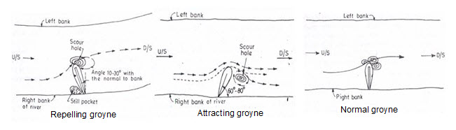
Fig. 13.6. Gryones (Repelling, Attracting & Normal) Types.
(Source: Asawa, 1993)
Spurs are also classified as full height spurs and part height spurs. Where top level is higher than the highest flow level (HFL) of the stream, it is called a full height spur. All these spurs are generally extended into the stream with straight head end. However, spurs are also constructed extending into the stream with a ‘T’ head or hockey stick shaped head (Fig. 13.7), properly designed to hold the river flow at a distance. A series of such spurs/groynes correctly positioned can hold the river at a position away from the point intended to be protected. The edge of the ‘T’ head should be curved somewhat in the manner of a guide bund to avoid swirls. The banks get protected from certain distance upstream and downstream of the groynes. The maintenance procedures specified for guide bunds apply equally to spurs/groynes also.
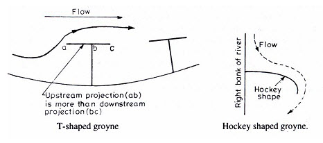
Fig. 13.7. ‘T’ Head and Hockey Stick Shaped Head Gryones.
(Source: Asawa, 1993)
13.4.3 Marginal Bunds
Marginal bunds are provided to contain the spread of the river when the river in flood spills over its banks upstream of the bridge site over wide area and likely to spill in the neighbouring water courses or cause other damages. The marginal bund should normally be built well away from the active area of the river. The slope should be well protected by turfing. Where a marginal bund has to be built in the active area of the river, it should be protected with pitching and apron. The earth for the construction of marginal bund should preferably be obtained from the river side. The upper end of the marginal bund should be anchored into high ground well above HFL. Marginal bunds should be inspected every year along with the annual bridge inspection and necessary repairs should be carried out before the onset of monsoon. Cattle crossing and rodent holes across the marginal bund should be specially watched and protected.
13.4.4 Closure Bunds
Sometimes it may be necessary to entirely block one or more channels of the river in order to prevent the discharge of such channels developing into a main river channel after the construction of the bridge. This is done by providing a closure bund. The bund is designed as an earthen dam. The same is generally constructed at some distance from the railway line. Special care should be exercised to guard it against its failure. It should be inspected every year after the monsoon and necessary repairs should be carried out.
13.4.5 Assisted Cutoffs
Sometimes when very heavy meandering develops near bridges and there is a danger of its encroaching too heavily into the still water area or otherwise dangerously approaching the embankment, it becomes necessary to dig a cut-off channel which will ultimately develop and help in the diversion of water through it. To make it economical, a pilot channel cut is usually made when there is low flow in the river and full development of the channel takes place during the flood. This cut off channel should preferably have (i) at least three times the river’s straight regime slope, and (ii) the upstream end should take off from where the bed load of main channel has less than the average amount of coarse material i.e. from the active part of the channel where the velocity is more. The entrance to the pilot cut should be bell shaped to facilitate entry of water. The chord loop ratio should normally be greater than 1 to 5 if a successful channel is to develop. Cut off should be planned with care taking all relevant factors into account.
13.5 Design of Spurs
The design of spurs for river training and protection mainly consists of identifying the number of spurs required to protect a certain stretch of the river length depending upon the size (effective length) of the spur. The selection of the length of spur depends upon the position of the existing bank line and the designed or expected bank line for the trained river. Too long groynes on easily erodible rivers make the protection susceptible to damage and failure. Along with the length of the spurs, spacing between the successive spurs is also important. Spacing between the spurs depends on the effective length and the types of banks to be protected. For an example, convex bank sides are protected with larger spur spacing whereas smaller spacing is suggested for concave banks. Another aspect in designing the spur spacing is dependent on the width of river. For wider river, larger spur spacing is preferred. Design of the spurs spacing is given below.
The spacing between the spurs or groynes generally bears a definite ratio to their length (l) exposed to the stream. The common practice is to keep the spacing (S) at about 7 to 7.5 times the effective length- h (vertical length from river bank) so as to effectively protect the bank. The total number of spurs required to protect the river bank can be calculated as:
 (13.1)
where,
N = number of spurs and
S = 7h, where h is the vertical projection of spur exposed in the river stream.
If θ is the angle of inclination of spur from vertical, then
![]() (13.2)
(13.2)
where, l = length of spur exposed to the stream.
In placing spurs, care should be taken to see that they are never constructed at a point where severe bank erosion is taking place but should be placed at some distance upstream. One or two extra spurs should be placed upstream side for effective protection of eroding stream bank and safely guiding the stream.
Solved Problems: Spur Design
1. Find out the number of spurs to control one side of the stream bank of 150 m length. The average flood flow is 5000 m3 /sec. It is given that the length of spur is 10 m and angle of projection is 30° from the vertical.
Solution:
Total length of eroded bank, L = 150 m
Projection angle from vertical, θ = 30°
Total length of spur =10 m
We have,
Length of the spur exposed to the river- l (assume that one third of total length is embedded into the bank)
l = 10 x 2/3 = 6.67 m
Vertical projection of spur exposed in the river stream-
h = l cosθ = 6.67 x cos 30° = 5.78 m
Let us assume the spacing of spur (S) = 7 h
= 7 x 5.78 = 40.4 m
Thus number of spurs required to protect eroded downstream (using equation 13.1)
N = (150/40.4) + 1
= 4.71 = 5 spurs
Assuming that 2 spurs are provided towards the upstream face additionally, total number of spurs required = 5 + 2 = 7 spurs.
Keywords: River Types, River Training, Spur Design
References
Railways bridge manual, Eastern Central Railway, Indian Railway, URL: http://www.ecr.indianrailways.gov.in/uploads/files/1350583817617-bridgem_i.pdf
River training, URL: http://rivertraining.webs.com/
National Park Service. Rivers, Trails & Conservation, URL: http://www.nps.gov/ncrc/programs/rtca/nri/states/tn.html, accessed on 29th September 2013
Asawa. G. L. (1993). Irrigation and Water Resources Engineering. Wiley Eastern, New Delhi.
Suggested Readings
Asawa. G. L. (1993). Irrigation and Water Resources Engineering. Wiley Eastern, New Delhi.
Melville. B. W. and Coleman .S. E. (2000). Bridge Scour. Water Resource Publication LLC.
Last modified: Friday, 20 December 2013, 6:24 AM